Road trips

The Final Frontier

Alert readers will recall that in my May 25 blogpost, I wrote:

In the town of Mason, Wisconsin a gas station attendant encouraged me to check out an old, abandoned, Wild West theme park that was homemade by a man (recently passed) named Ed Sandor on his farmland. This I did, and it was one of the most enjoyable hours I’ve spent. It deserves its own blog post, which I hope to write in the next day or two. 

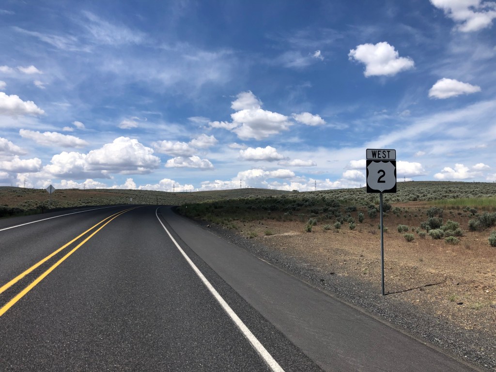
I’m now finally able to share the whole story. It was a cold, drizzly spring day in rural Wisconsin. The somewhat rustic attendant at the nondescript gas station noticed my rental car’s Florida plates and made the observation that I was a long way from home. I told him about this road trip, and he said, “Well, then I reckon you oughtta check out the old Sandor place. He built an Old West town to entertain the kids while families camped on his farm. It’s abandoned and pretty run down, but it’s still worth a gander.” I told him I was game, and he provided me with moderately vague directions, using terms like “Bill Rabbs farm” and “the place where the school bus stops” as landmarks. Undeterred, I drove about a mile off of Route 2, and spotted the old, weathered sign the attendant had mentioned.

Why am I thinking of the Bates Motel?

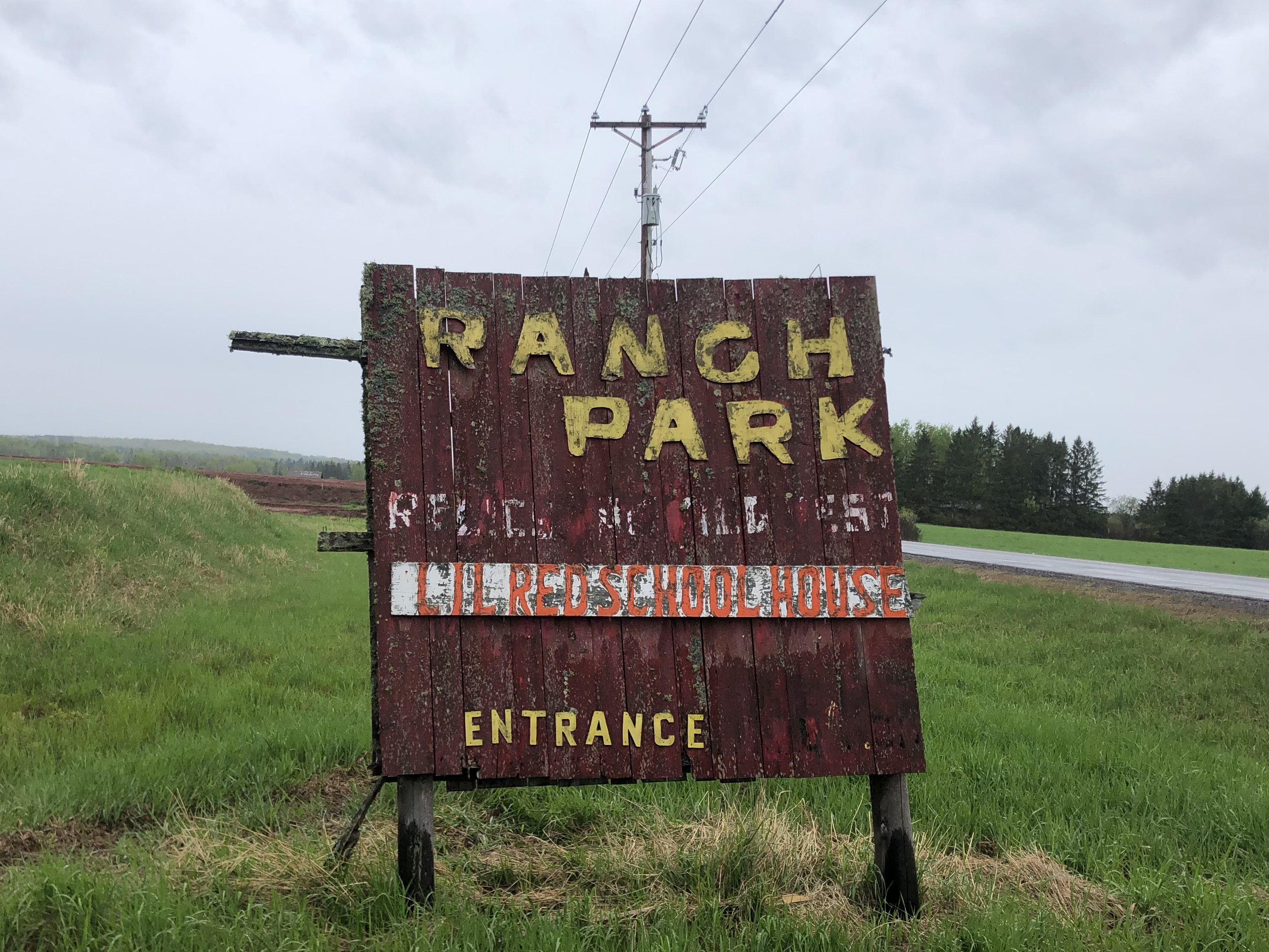
The sign stood next to a narrow dirt road which had been dampened by the morning drizzle. I put the Jeep into 4WD mode and turned onto the dirt side road. Wooden fences ran along both sides of the road, presumably marking private property. After about half a mile the road split into two, narrower dirt driveways. This sign was posted at one of the driveways:

Country hospitality

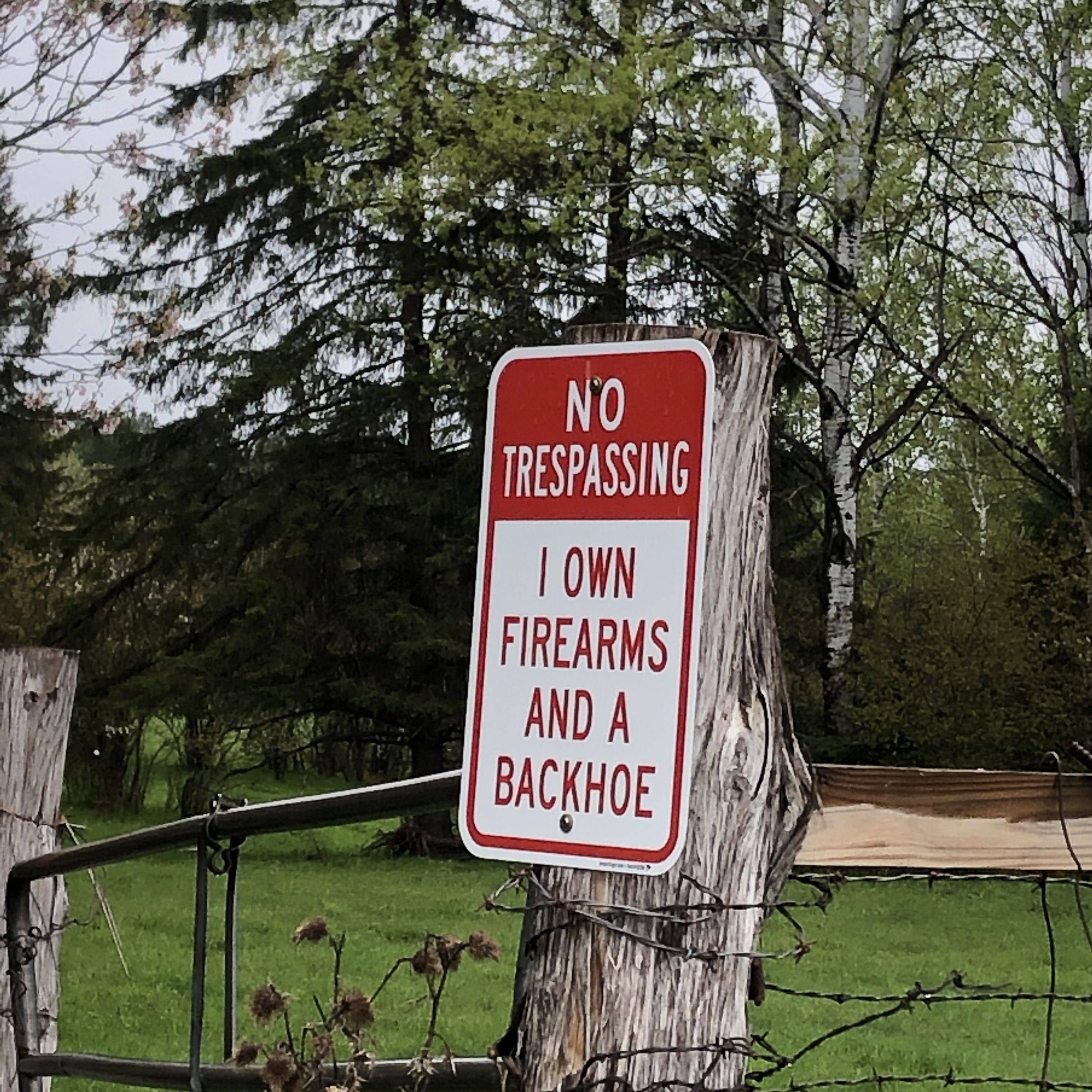
Needless to say, I took the other driveway.

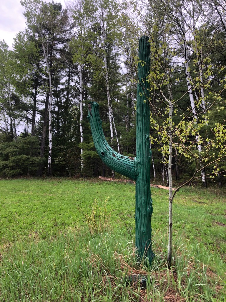
Just as I thought I’d been led on a wild goose chase I spotted a fake, cartoonish saguaro cactus which would be de rigueur at a 1950s Old West theme park. I had to be close.

Invasive species

Then, around the next curve, I arrived at what must be Ranch Park….though I still didn’t really know what to expect.

This is not my beautiful house.

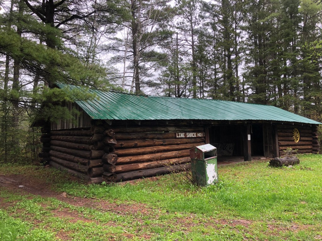
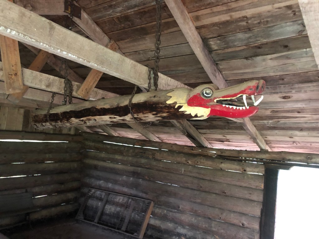
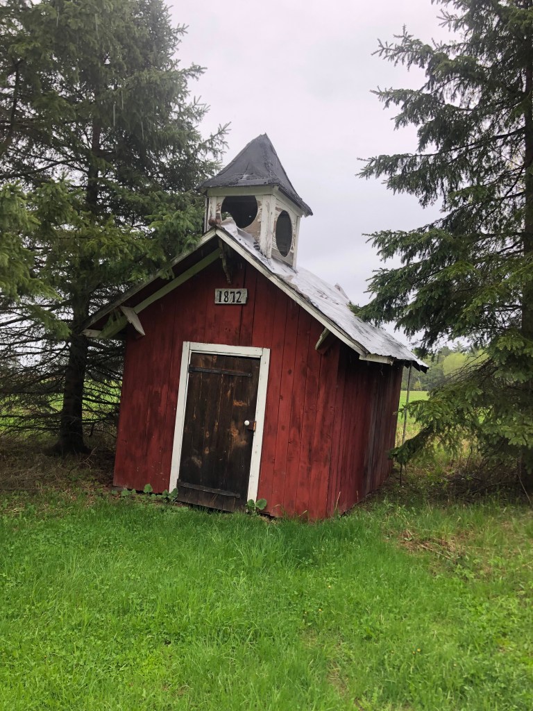
A rustic log cabin with a doorless open front stood in front of me, with a sign indicating that it was “Line Shack No. 1.” It was largely empty, except for a couple of picnic tables and a large, carved serpent (?) hanging from the rafters.

Serpentine wood carving?

Based on a few notices stapled to a bulletin board, I determined that this had been a communal gathering place for people who camped on Ed Sandor’s land. But if that saguaro cactus was all that makes this an “Old West theme park,” I’m sure the visiting kiddies were disappointed.

The rain was coming down harder, so I told myself I’d just make a quick search of the grounds for something more interesting before I left. A sign pointed to the “History Story Trail,” and when I walked 100 feet in that direction I encountered a carved, life-size viking.

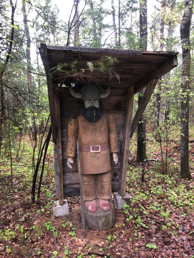
OK, this didn’t exactly evoke the Old West, but it was definitely getting interesting. The Viking stood near the beginning of an overgrown trail. I got onto the trail, thinking perhaps I’d find a carved Visigoth.

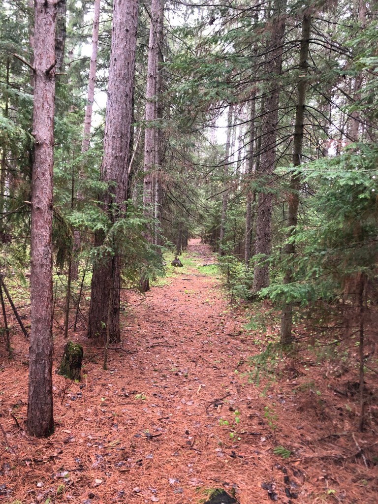
Here and there along the trail someone had staked small paper signs, obviously not suited for outdoor use. They seemed intended to educate visitors about various aspects of pioneer life.

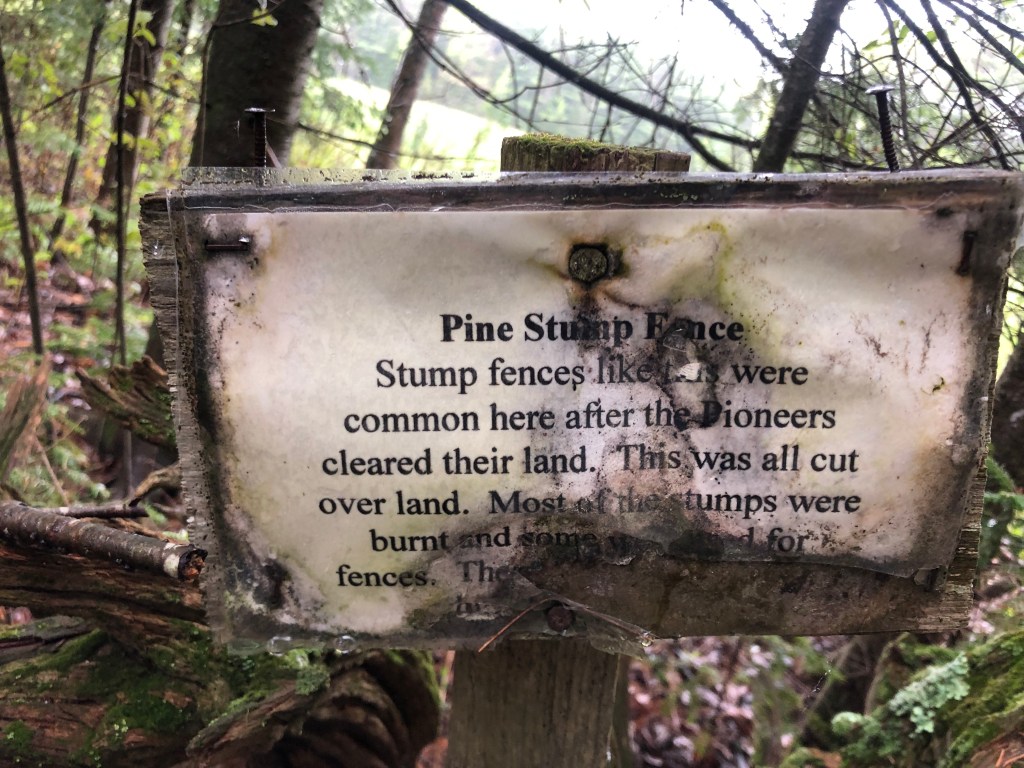
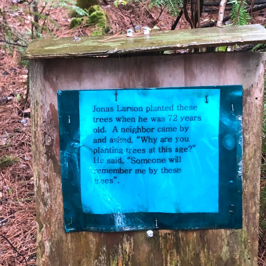
I studied each of these little placards as I passed them, and before long I stumbled upon a rabbit hole. Literally.

What’s next? “Tresspassers Will”?

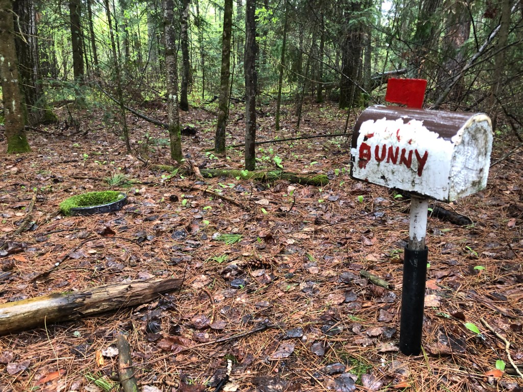
I continued to push forward, encountering these small gifts as though they’d been left by Boo Radley in a tree’s knothole. Finally I reached a clearing and I discovered what all the fuss was about.

Howdy, Pardner

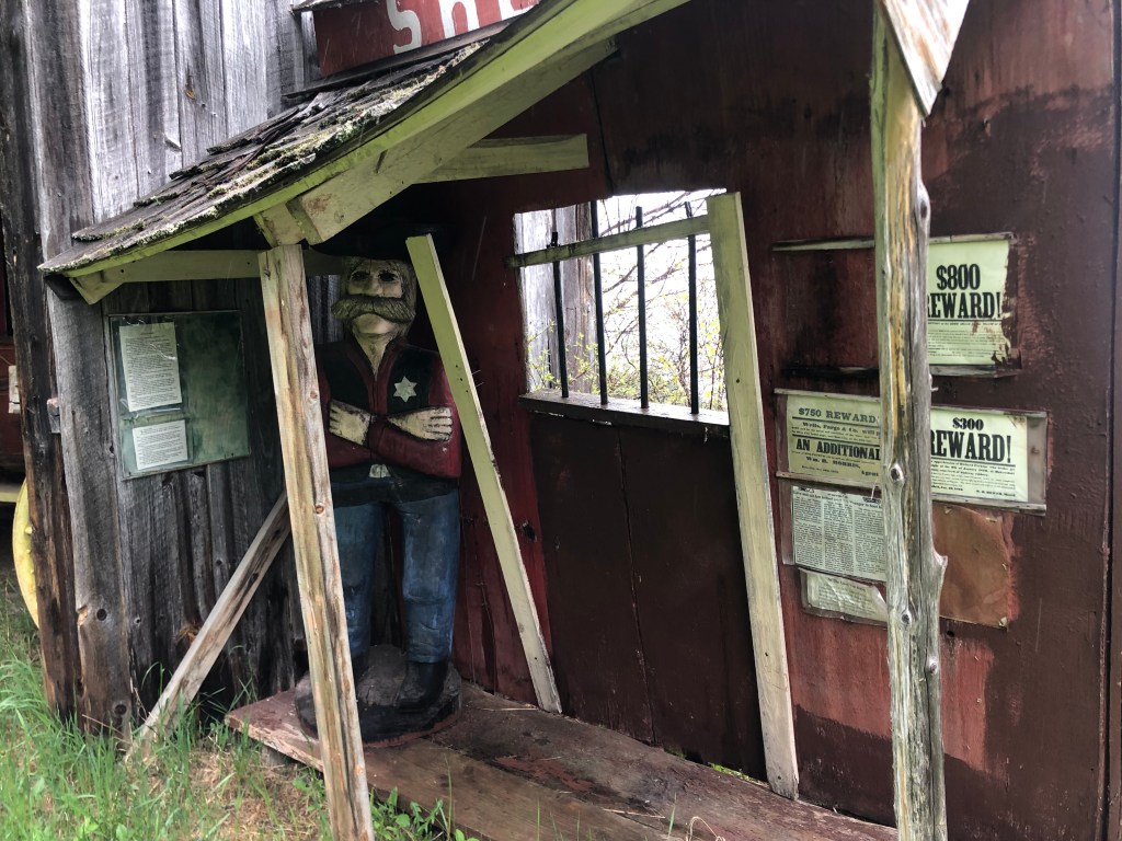
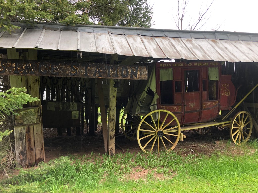
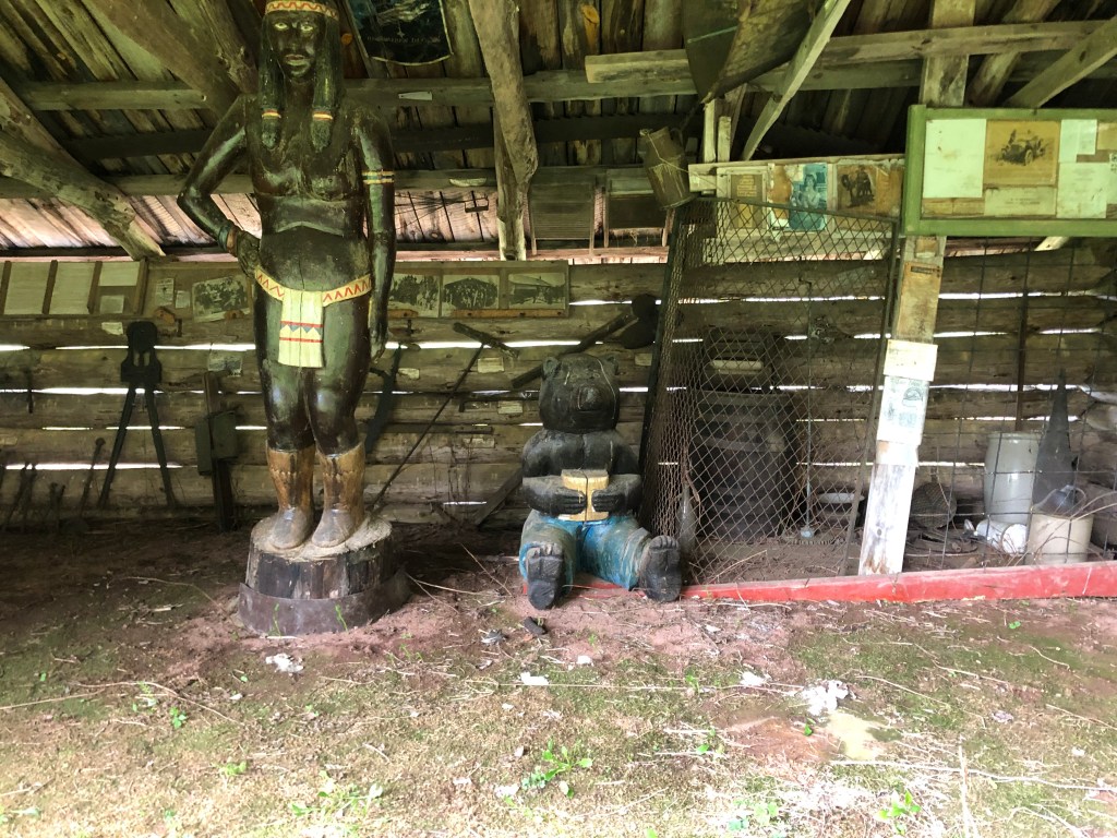
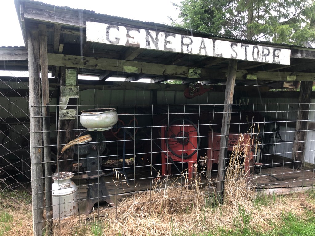
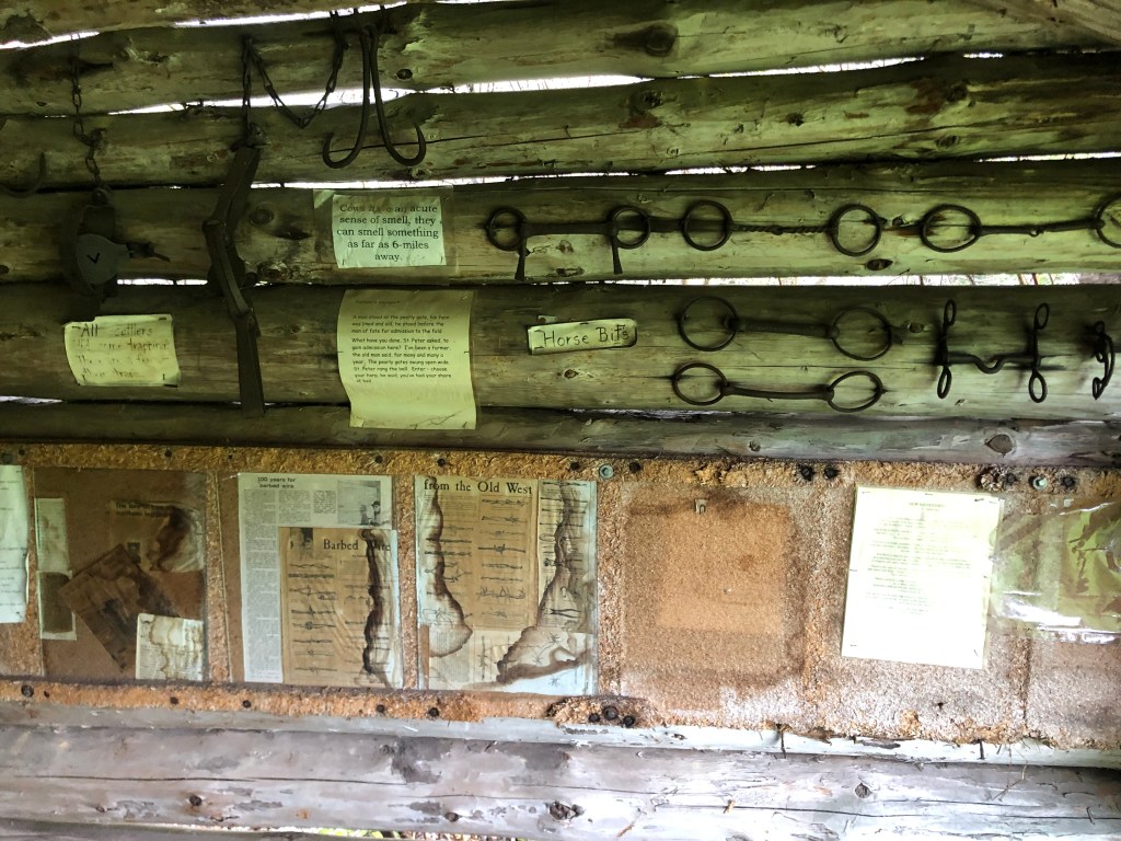
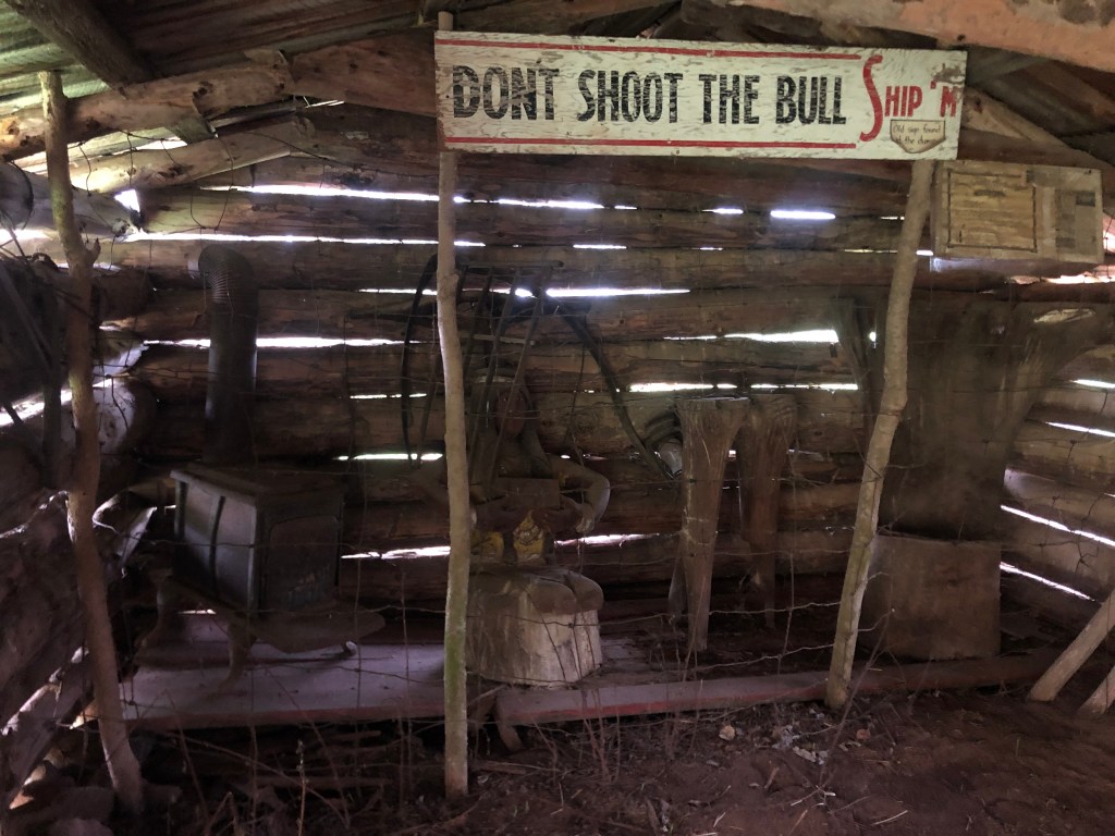
It was remarkable. Ed Sandor had built a small cluster of buildings, resembling a frontier town of the Old West, and filled them with various artifacts, most of which are authentic. There were carriages, tools, furniture, saddles, bridles, books, cookware, and numerous other antiques. What’s more, they weren’t behind glass or protected with cameras or alarms. Everything was just sitting out there to be touched, examined, and appreciated. (There were a few displays behind chicken wire, but it would be easy to circumvent and I think it was just there to keep the youngest kids from getting themselves in trouble.)

It wasn’t a carefully-curated collection by any stretch of the imagination; the displays didn’t have much rhyme or reason. But there were some explanatory labels and newspaper clippings tacked up here and there.

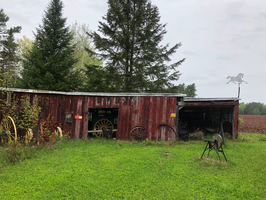
The photos included here barely scratch the surface of the collections hidden away here in the woods. And I later learned that Ranch Park used to be even more extensive, back in its day. Ed Sandor (1924-2019) began to accommodate camping on his farmlands in the 1950s, and in the early 1960s he began creating this western theme town pretty much single-handedly. It grew to become a popular stop for families, much like some of the tourist attractions along Route 66 in its heyday. Ed Sandor and his family kept the place running, making small repairs as needed and occasionally adding some new displays. Sadly, Ed’s declining health forced him to stop working on the Ranch in 2015. He died in 2019, and the Ranch is now for all intents and purposes abandoned, left to decay in the elements.

Here’s a video that shows the Ranch a few years before I visited:

I have a hard time putting into words my feelings as I walked among these decaying displays. The dark skies and drizzling rain, coupled with my being isolated in the forest far from home, lent a distinct melancholy feeling. I felt sad that Ed Sandor’s life work was being left to disintegrate; surely the place would be unrecognizable in a few more years. It also seemed like a waste that no one was working to preserve those genuine and rare artifacts. And I had a nostalgic longing for those simpler times of my childhood, where entertainment was found outdoors and we played in a tangible (rather than digital) world.

And yet there are some positive and hopeful aspects to this story. For starters, Ed Sandor spent over 50 years running this “ranch” and entertaining kids and families. In a guest book next to Line Shack No. 1 are hundreds of heartfelt testimonials from grownups who have fond memories of the place from their childhood, and from people like me who just now discovered it.

Another thought that struck me was that there wasn’t a single jot of graffiti anywhere at the ranch. This place is completely open and has been abandoned for about 8 years now, and yet no one has felt an urge to deface it. I can’t say for sure whether anyone has walked off with any of the artifacts, but I can say that there is a treasure trove of artifacts that no one has disturbed. And I wonder if one of the reasons why comes from this little sign that Ed posted on the bulletin board by Line Shack No. 1:

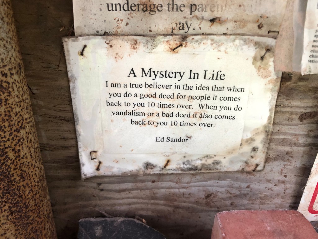
The world needs more Ed Sandors.

bridges · Golden Bear signs · Road trips · trains

3,773 Miles Later…

You’ll recall that I began this journey in Vermont and upstate New York, where I met with relatives and visited places where my grandfather grew up. After driving 3,773 miles, I’m ending the trip by visiting places where my grandmother grew up. There’s a certain symmetry in all that, which I find strangely satisfying.

I set out this morning from Wenatchee, and soon the environment was changing again. This time it felt like I was in Germany….and that’s because I passed through the town of Leavenworth (pop: 2,500), which for some reason has decided to dress up as a Bavarian village. Like so many towns along Route 2, Leavenworth was founded over 100 years ago as a Great Northern railroad town. It even housed the regional office of the GN. But the office was relocated to Wenatchee in 1925, and then the remaining major industry (timber) steadily declined into the 1950s. The town needed a new source of income, and by the 1960s it settled on a strategy: It would seek tourism dollars by recreating itself as a Bavarian village. No doubt you’re familiar with the town of Solvang on the Central California coast; it’s the same idea. Indeed, Leavenworth officials actually visited Solvang as they were developing their strategy.

I knew I should have packed my Lederhosen!
Are there no German tropes Leavenworth is unwilling to exploit?

Leavenworth has a live webcam trained on its town square. I’m sure it would be fun to watch during Oktoberfest. But right now, not so much.

They even made Starbucks alter its logo.

Immediately beyond the town the North Cascade Range looms, as you can see in the picture below. I was about to experience yet another change in scenery….

Going up…

Route 2 through the Cascades is a truly beautiful drive. The road follows the Wenatchee River, which is impressive and scenic.

Flowing toward the Wenatchee Valley Brewing Company. Seriously.

You’ll recall that a few days ago US Route 2 took me over the Rockies at Marias Pass in Montana, and I noted that the Great Northern Railway ran its transcontinental route over that pass in 1889. The last segment of Great Northern’s transcontinental tracks to be completed was the section over Stevens Pass, right here in the Cascade Range.

Crossing the Cascades at Stevens Pass.

So this morning I stopped on the Pass near the point where the final railroad spike was driven on January 6, 1893. There’s a placard commemorating the event.

A creek runs by this same spot. It’s called Deception Creek, and I’ve been unable to find out the story behind the name. (Please enlighten me, if you have info.) I did manage to take this short video of the creek running under Route 2.

On the other side of the pass I came to the town of Skykomish (pop: 190). Like Leavenworth and many other towns along Route 2, Skykomish was established as part of the Great Northern Railway’s surveying efforts. For about 80 years it provided maintenance and fueling services for the Great Northern. Today, however, the GN doesn’t even stop at Skykomish’s historic depot.

The tiny tracks in front of the depot are for a kiddie-size train ride.

Still, Skykomish continues to link its identity to the Great Northern. Indeed, the town seal incorporates a version of GN’s logo, and it calls itself “A Great Northern Town.”

The railroad’s actual logo.
Look familiar? GN’s goat (named Rocky) is everywhere in Skykomish.

Like Leavenworth, Skykomish seems to have found a niche with tourists. In Skykomish’s case, it’s railfans that they’re courting. They have a restored depot that’s now a museum, they offer train rides, they’ve plotted a walking tour of historic GN-era buildings. And while passenger trains no longer stop in Skykomish, plenty of freight trains pass through the town, making it a good location for train spotting. In addition to all this, the town has several upscale cafes, coffee shops, and outdoor equipment purveyors that are popular with a wide variety of tourists.

1905 Skykomish Hotel, restored and with viable tenants.

After an enjoyable walk among Skykomish’s streets (which, among the older historic structures, include this WPA-era school building that’s still in use), I eased back onto US 2. I was getting dangerously close to the western terminus at Everett.

In continuous use for 86 years.

Now, recall that a few days ago, when I was in Glasgow, Montana, I met a guy named Chris at the Loaded Frog who explained the “Middle of Nowhere” slogan to me. Well, Chris also told me that there’s a good taproom near the western end of Route 2. I’ve been looking forward to checking it out ever since I learned of it. With a little research I discovered that the place–the Route2 Taproom–is in Monroe, WA, which is about a dozen miles before the end of Route 2.

Serving beer to thirsty Route 2 travelers since 2015.

I stopped in and ordered the Triplehorn Nemesis Milk Stout on Nitro. So let’s get the BOTD out of the way:

Maggie at Route2 Taproom serves up a perfect stout.

What a great choice for my final BOTD! It’s got a complex range of flavors, and somehow they work together nicely: There are hints of coffee grounds, vanilla, tobacco leaves, and those miniature Hershey’s bittersweet chocolate bars I used to get at Halloween. The hops are reined in a bit, which is appropriate for a milk stout. The mouthfeel is creamy (that’s partly due to the nitro), and it’s pretty boozy at 10% ABV. It would be really hard to improve on this. I give it 5 stars.

Saved the best for last.

Refreshed and rejuvenated by a good stout, I got back in the car and set out on the last few miles of the trip. And just when I didn’t think my luck could get any better, I spied a Golden/Laughing Bear sign! And what’s more, unlike some of the other such signs I’ve encountered, this one was affixed to a still-operating wheel alignment business. Surely the gods are smiling on me today.

If you zoom in on the window, you can see a second Laughing Bear on the other side of the glass.

And then, after all this, I was driving the final mile of Route 2. I had arrived in Everett (pop: 111,000, which might be about equal to the combined population of all the other towns I visited along Route 2!) The western terminus of Route 2 in Everett is where Maple Street and Interstate 5 meet. Disappointingly, I was unable to find a sign marking the end of the westbound highway. (I couldn’t find a sign marking the beginning of US 2 East, either.) So all I can show you by way of evidence is this photo of where, in theory, the route ends:

Anticlimactic ending

There was no brass band, no one to hand me a key to the city, no banner strung across the roadway for me to snap with my car. My journey simply ended.

Having dispensed with Route 2, I next headed down to Tacoma (pop: 216,000) to visit some places where my grandmother–and, later, my dad–grew up. This blog isn’t the place to go into any detail about the sites I saw, but I will offer this photo of Grandma’s high school, which is still educating students after 107 years.

Grandma walked these halls almost 100 years ago.

Finally, I will be making a final post tomorrow about a memorable visit I made to an abandoned Old West theme park in Wisconsin. I mentioned it in passing in my May 25 blog, but I didn’t have enough time to do it justice. This I will do tomorrow while I’m waiting for my plane.

Until then.

churches · Hydrology · Road trips

Dam Detour

So, here we are in the final state of this two-week odyssey. Not only have we traveled through 11 states (VT, NY, PA, OH, MI, WI, MN, ND, MT, ID, WA), but along the way we’ve seemingly experienced most of the types of terrain this country has to offer. For example, today I left behind the green mountains of western Montana and Idaho, and entered the flat, arid, scrub brush-covered badlands of eastern Washington.

The parched landscape of eastern Washington.

There’s not a lot of settlements out in this part of the country. One of the isolated towns I drove through this morning was Wilbur (pop: 900). It’s worth quoting Wikipedia about how the town got its name:

Just prior to the construction of the Central Washington Railroad line in 1889, no towns existed west of Davenport in Lincoln County. One place along the line, “Wild Goose Bill’s Ranch,” run by Samuel Wilbur Condit, was assigned a post office by the Federal government. Condit was 62 years old and known throughout the region as Wild Goose Bill when he and another man shot each other to death on Jan. 21, 1895. Condit platted the town that bears his middle name “Wilbur,” though he didn’t have anything to do with the naming. Goosetown was a consideration, until the blacksmith’s wife complained that she would never live in a place with such a silly name. Instead, the name Wilbur was chosen by town surveyors.

OK, so knowing that, check out this mascot next to the visitor’s center:

I won”t comment on the unusual shape of the anorexic pig, but I will note that a wire spiderweb (barely visible in the below photo) bears the name Wilbur. Clearly the Chamber (or whoever is responsible for this pig) doesn’t know the true origin of the town’s name. But E. B. White must be smiling.

A little past Wilbur on Route 2 is the town of Coulee City (pop: 550). With all due respect, it’s not much of a town…but it is home to “the world’s largest waterfall.” The only catch is there’s no water. Let me explain.

Waterless waterfall.

Scientists have determined that at the end of the last ice age, an ice dam blocked a river in Idaho, which gradually created an enormous lake that reached into Montana. Eventually the ice dam failed, and the stored water rushed westward toward the Pacific, scouring the landscape along the way. This evidently happened a number of times, and the hydraulic activity created these “coulees” (deep ravines), which in turn produced enormous falls when the next flood occurred. The falls at Coulee City were over 400 feet high and 3.5 miles across.

All this reminded me of a cul-de-sac near my childhood home named Grand Coulee Court. It’s where Phillip Waters lived. (I’m not making up that serendipous surname.) Did this ravine I was now taking photos of–called a “coulee”–relate in some way to “Grand Coulee”? Then, somewhere in the back of my mind, I remembered there’s a “Grand Coulee Dam,” though I didn’t know any details about it. A quick consultation of my trusty road atlas (that I’ve been carrying around since 2010) informed me that the Grand Coulee Dam was a short 20-minute detour from Coulee City. So off I went.

I won’t bore you with the details, but the basic points are these: The US Bureau of Reclamation built the Grand Coulee Dam in the decade leading up to World War II. The dam is on the Columbia River, creating a reservoir (Lake Roosevelt) from which water is pumped to irrigate farms in central Washington. In addition, water passing through the dam powers generators which produce the largest amount of hydroelectric power in the US (about 21 billion kilowatt hours each year.) I learned all this on a guided tour, which took me into the pump stations and onto the top of the dam.

The Grand Coulee Dam, viewed from downstream on the Columbia River.
On top of the dam with my tour group.

And if you’re interested, here’s a short video showing my view looking over the edge of the dam, on the downstream side.

Around noon I wound up this educational detour and reconnected with that familiar friend, Route 2. Along the way I drove through “Electric City” (pop: 1,000), whose name relates to the nearby Grand Coulee Dam’s generating capacity. But what struck me about Electric City was not its proximity to someone else’s generators, but rather a large collection of homemade windmill sculptures in a “windmill garden” next to a park.

Positively mesmerizing in person.

The sculptures were created by a hobbyist metalworker named Emil Gehrke, and they’ve supposedly been featured in National Geographic magazine. Gehrke created the sculptures from scrap that he collected from all over the world. He displayed the sculptures in his yard for years, but after his death in 1979 (at age 95) most of them were moved to this park.

Soon I reconnected with Route 2 and returned to my westward trek. I came to the town of Waterville, where I encountered the daily, obligatory former church building. Today’s ex-church started out as St. Paul’s Lutheran Church in 1915. It closed in 1968, when the congregation built a new church along with another Lutheran congregation. The old building was purchased by the local historical society in 2006, and it’s now used as a community center and wedding venue. The historical society did an impressive job of restoring the structure.

Look familiar?

I am spending the night in Wenatchee (pop: 35,000, which is one of the largest towns on this trip). Wenatchee is a comfortable, seemingly prosperous town at the confluence of the Wenatchee and Columbia Rivers, with lots of outdoor venues for enjoying the great weather. It calls itself “the apple capital of the world,” in reference to its many apple orchards.

I’ll end my description of today’s travels with these two semi-creepy floating faces that evidently had been employed for advertising purposes in the middle of the last century.

Atop an Office Depot in Wenatchee. (The sign was grandfathered in from the prior business on this site.)
Hamburger joint in Wilbur.

Tomorrow I’m planning to reach the end of Route 2, in Everett.

Brew(s) of the Day

Today’s BOTD comes courtesy of the good folks at Wenatchee Valley Brewing Company in Wenatchee, Washington. It’s the usual modern, western brew pub, with the brewery and service counter in a warehouse-like space, lots of outdoor seating with views of the busy street, and the ubiquitous corn hole game set up on the lawn. Wenatchee Valley Brewing is located on the bank of the Columbia River, which makes for a pleasant environment.

The usual setup.

I ordered the Trout Stout on nitro. (“Nitro” is a dispensing process for some draft beers–particularly stouts–which uses nitrogen rather than carbon dioxide, lending a creamier mouthfeel.) I have to say that it was a good presentation, and a tasty brew. The beer is a dark-chocolate brown, with a thick, creamy, tan head. The taste is remarkably smooth and balanced. It manages to avoid the bitterness that plagued the last few stouts that I’ve drunk. The main flavors that come through are roasty ones: espresso, burnt toast, maybe a little bit of roasted chestnut. And at only 6% ABV, this is a very drinkable beer. Recommended. I give it four stars.

Powered by nitro.

Now, recall that I couldn’t find a BOTD yesterday, so I’m making up for that by having a second BOTD today. Loyal reader Ron P. sugested I have a hazy IPA, but there are none to be found at this place. So instead I had a “Hopcicle Double IPA.”

Not hazy, but definitely boozy.

This is a good summer brew, made all the more enjoyable because I’m sitting outside in the warm sunshine with it. It’s pretty sweet for an IPA, with hints of honey and marmelade. Hops balance out that sweetness, but it doesn’t taste bitter. It’s got a light body, which makes it go down pretty easy. But it’s 9.2 percent ABV, so they serve it in a smaller (12-oz) glass. Which is a good thing, I’m sure. I give it 4.5 stars, but that might be alcohol talking…

bridges · churches · Road trips · trains

Potatoland

This morning after an unhealthy breakfast I left Kalispell and headed west toward the Idaho border. This is beautiful country–the many small lakes, the Kootenai River, several national forests, the Purcell and Cabinet Mountains… The towns out here are much more vibrant than the towns along the Hi-Line (a term which no longer is used west of Glacier National Park). The towns also feel a bit more optimistic and playful, which shows up in the extensive roadside art installations.

Trailer-On-a-Stick in Libby, Montana
Cross between a Sasquatch and Jerry Garcia?
What is it about Montana and these stick-mounted vehicles?
Giant fishing pole with the catch of the day.
A Clockwork Moose

Along this scenic stretch of northwestern Montana, somewhere between the towns of Libby (pop: 2,800) and Troy (pop: 800), I saw a large number of vehicles parked in a roadside parking lot, with lots of activity as couples and families walked toward a trailhead. I figured I’d park and see what all the fuss was about. It turns out the approximately 3/4-mile-long trail leads to the Kootenai Falls Swinging Bridge.

What could go wrong?

It’s a simple suspension footbridge, 210 feet long, strung 100 feet above the rushing waters of the Kootenai River. Now “swinging” is not generally considered to be a desirable characteristic of a bridge, but the lateral movement is limited by heavy cables, so it sways rather than swings. Plus, you have to admit it’s kind of fun to watch the people ahead of you freaking out. At great personal risk, I took a video of myself crossing the bridge, for the benefit of you, my loyal readers.

Yes I know I’m holding the camera wrong…

After surviving that ordeal, I got back on Route 2 and eventually entered the Potato State. (Idaho actually calls itself the Gem State, but what non-Idahoan has ever called it that?) The first Idaho town I encountered was Bonners Ferry (pop: 2,700). Bonners Ferry calls itself “Idaho’s Most Friendly Town” and that’s a plausible claim. The people seemed warm and welcoming, the motorists waved and yielded the right-of-way, and even the teenagers made eye contact and said hello while passing on the sidewalk. Of course, I’m told that Idaho is beset with an influx of expatriat Californians who are seeking lower taxes, cheaper housing, and fewer wildfires. So we’ll see just how friendly these Idahoans remain.

It was in Bonners Ferry that I saw my daily, obligatory converted church. This particular one looks like it could be haunted. It was built as a Roman Catholic church in 1894, and has been operating as the Pearl Theater since 2012. It seems to be a well-used facility judging by the list of events which shows something (poetry reading, music programs, language classes, belly dancing, movies) happening most days.

Tim Burton would love this place.

Although I left the Great Northern’s Hi-Line behind in Glacier, Route 2 continues westward alongside a set of railroad tracks. I clambered down a hillside to take a photo of the trains’ right-of-way beside the river. This would make a great rail journey!

Speaking of trains, when I got to Sandpoint ID (pop: 8,700) I noticed a historic railroad depot on the other side of Route 2, which runs on an elevated roadbed as it cuts through the downtown. It took me half an hour to find a way to get to the depot, and once I did I was rewarded with this beautiful 1916 structure.

Shockingly this is the only operating Amtrak station in the entire state of Idaho. It is served by two passenger trains a day (one from each direction). As I was taking photos I was greeted by Maggie, who was locking up the station. Maggie had been the station’s first female station agent (I hope I have that title right; Maggie, please correct me if you’re reading this) and is now retired from that position. But she still does contract work for Amtrak, which includes opening and closing the station, as well as some other property management tasks. She generously showed me around the station, which still has much of its original interior woodwork.

Maggie (L) with helper Vickie
Sandpoint’s waiting room

The city of Sandpoint sits on Lake Pend Orielle and is flanked by mountain ranges. As such, it is a major tourist destination. It even has its own miniature version of the Statue of Liberty.

“Bring me your huddled masses yearning for potatoes.”

By the late afternoon I was already leaving Idaho, since US 2 just cuts along the state’s northern panhandle for about 80 miles.

Red line is Route 2 through Idaho. Today’s drive went from Kalispell in the east to Spokane.

I crossed into Washington and I’m spending the night near Spokane. The only notable photo I took in downtown Spokane was of the 1913 Sunset Boulevard Bridge. (Route 2 travels on a more modern bridge paralleling this bridge, but I figured it was worthy of inclusion since it’s a feature you see while traveling Route 2.)

Golden Arches

And for fun, check out this historic photo of the bridge under construction:

With that excitement out of the way, I had great hopes of getting a beer at Iron Goat Brewing. But when I got there I encountered a locked door and a sign saying that they’re closed for Memorial Day. (One wishes Google Maps had been made aware of the closure.) Two other brewpubs were similarly closed. So no BOTD today. I guess I’ll just have to have two beers tomorrow.

Obelisks · Road trips · trains

Rocky Mountain High

Today I finished crossing the Great Plains and made my way over the Rockies. But to start at the beginning:

The Hi-Line/Route 2 in Montana cuts through exceedingly wide, open spaces–at least until you get to the western mountains. I think this is what makes the smallest of ancient settlements stand out in such stark relief; one’s eye is drawn to any interruption of the rolling prairie.

The Unbearable Flatness of Being

Now, one of the great things about much of US Route 2 is that it closely parallels Great Northern’s transcontinental route. Small towns were established all along the Hi-Line, and almost all of those settlements still exist in one form or another. Most of them still retain some aspect of their original, century-old incarnation, which makes this drive feel like a journey through an earlier time. And the towns have looked for ways to remain relevant and economically viable–with varying degrees of success. If they don’t do it right, their young people seek opportunities elsewhere, the labor force goes away, business dries up, and the town shifts into ghost town status.

Witness to long-past better days.

Let’s take two examples from today’s journey. The first is the town of Kremlin, MT (pop: 98). The unusual name owes to founding by ethnic Russian homesteaders in the early 20th century–before the Russian Revolution.

Kind of like Gangnam Style, only different.

I took a quick pass over the town’s dirt roads and saw only one business (a bar), several derelict granaries, and a handful of houses in various states of disrepair. The only public building I saw was a school house, which was evidently permanently closed.

The former Kremlin school (now permanently closed.)

Kremlin is fast approaching ghost town status, with the population dropping about 20 percent per decade. You can almost feel the despair in the air.

Just a few miles up US Route 2 is the town of Rudyard (pop: 200), named after Rudyard Kipling. (An outdated sign at the entrance to town boasts “596 nice people and one old sorehead.”) But it was the sign announcing the Rudyard Depot Museum that caught my eye. I turned down the narrow main street and came to the museum complex, which is a collection of tidy buildings behind a memorial rock wall.

Some of the Rudyard museum’s buildings. The depot is in the center.

A sign on a locked door said “We really want to show you the museum; call this number and we’ll come right over.” So I called, and within 3 or 4 minutes a friendly, talkative woman named Willie showed up. She then spent well over an hour showing me around each of the buildings. It’s really an astounding collection: Uncountable historic household goods, rows of showroom-quality refurbished tractors and buggies, various agricultural implements, shelves full of about 100 historic railroad lanterns, turn-of-the-century appliances, military uniforms, telephone switchboards, and beauty shop hairdryers that look like they could give you a lobotomy. The collections are housed in a historic upper-middle class house, a railroad depot, a post office, a homesteader’s cabin, and other buildings. After an hour we had barely scratched the surface; I could easily have spent the whole day there.

This photo c/o TripAdvisor’s website.

But beyond all that, they have something that drawfs the other collections I’ve mentioned: They have dinosaurs.

A small sample from Rudyard’s dinosaur collection. The skeleton in the foreground served as a model for Spielberg’s velociraptors.

You probably know that Montana is home to various fossil dig sites. It turns out that of the more productive sites is right here in Rudyard. And a very large number of specimens–individual bones, complete skeletons, and full-size models–are housed in a separate building at the museum. The collection is so authentic and extensive that it’s frequently visited by paleontologists and other academics. Plus, Stephen Spielberg came here when he was working on Jurassic Park.

All of this is collected, organized, and maintained by volunteers from Rudyard. Many hundreds of visitors come through each year, and they are all warmly welcomed by Willie and the other volunteers. It’s a significant labor of love, and really says something about the pride these people have in their comunity.

Willie wouldn’t give me permission to show her face in the blog, but here she is pointing out some of the detailed, historical town data that the museum has collected.

There are other aspects of the town that reveal a special pride, such as the playful population sign at the town entrance. (Willie acknowledged that the population has been dropping, not just in Rudyard but all along the Hi-Line. That’s why Kremlin’s school closed, and their children now come to school in Rudyard.) Rudyard is also distinguished by a number of historic buildings lining the main street.

One of the nicely preserved buildings on Rudyard’s main drag.
Rudyard’s 1949 Hi-Line theater is a little rough on the outside, but they still show movies on the weekends. It’s the only theater within a 100 miles. And their 1949 popcorn popper still churns out the popcorn.

I thanked Willie for her time and got back on Route 2, stopping at each small town that I passed. A few of them still have railroad depots, though many do not. The depot-less towns seem especially isolated and neglected. Still, each of these towns has at some point tried to market itself to the world with a nickname. For example, Joplin (pop: 150) calls itself the “biggest little town on earth.”

I hadn’t realized that Montana took up so much of the earth’s surface.

Meanwhile, Cut Bank (pop: 3,000) calls itself “the coldest spot in the nation.” Which is strange, because after I passed through Cut Bank and went up into the Rockies, the temperature dropped precipitously.

Dubious claim and incredible feet.
Cut Bank’s unusual 1918 depot. The young woman at the ticket window told me that the town is growing fairly rapidly.

Eventually, after hours of driving the flat, open landscape of northern Montana, the horizon suddenly changed. Route 2 was about to ascend 5,000 feet into the Rockies.

Rocky road ahead.

The Great Northern Railroad found a suitable pass and constructed a route over the summit of the Rockies in the late 1800s, but Route 2 didn’t extend over the mountains until 1930. In the interim, automobiles were loaded onto rail cars and transported over the Rockies by train.

Great Northern’s 1912 depot in East Glacier–where you’d load your car for the trip over the summit.
Speaking of the summit….Crossing the Continental Divide on Route 2.
…and at the summit there’s a 1931 obelisk in honor of Theodore Roosevelt. It originally was placed between the two lanes of the newly-opened Route 2, but it was moved to the shoulder in 1989 “for safety reasons.” Special thanks to loyal reader Peter D. for bringing this monument to my attention.

Once I descended on the western side of the summit, the Route 2 driving experience changed again. The road skims the southern edge of Glacier National Park, and you pass numerous ski lodges, outdoor equipment rental businesses, coffee shops, lodges, restaurants, and other tourist-serving businesses. It feels like South Lake Tahoe in the 1970s. What a far cry from the desolation and tiny, struggling towns of the past couple of days.

Finally I stopped for the night in Kalispell, MT (pop: 25,000). It feels like a vibrant, prosperous town, taking advantage of its location at the gateway to Glacier National Park. It’s also the county seat of Flathead County, with a nicely restored courthouse and other civic buildings. Moreover, as described in the BOTD report (immediately below) it has more than one microbrewery.

Kalispell’s 1905 courthouse

Brew(s) of the Day

Based on a recommendation from loyal reader Ron P., I stopped in at Kalispell Brewing Co for their Imperial Stout (10% ABV). I rolled in around 5:30 pm, and they were already putting chairs on the tables for a 6 pm close. But I did manage to get a glass of their imperial stout.

Now, I don’t want to sound too high-maintenance, but what’s so hard about brewing a malty imperial stout? The offering at KBC is definitely overhopped. I mean, it’s pleasantly roasty, with dark coffee notes and a good creamy head. That’s good. But there’s simply no sweetness on the palate. This is unacceptable.

Next I moved over a few blocks to Bias Brewing, where bartender Rem recommended the Logan’s Lass Scotch Ale (8.5% ABV). I had a sample, and it was a pretty beer, with a slightly peaty (but not exactly smoky) flavor. But what I landed on was the Barro Sabroso Mexican Chocolate Porter (6% ABV). It was superb! After badmouthing porters a couple of nights ago, I now have found one of my favorite beers. This porter tastes almost exactly like a Mexican hot chocolate, with dark chocolate and coffee notes and a generous sprinkling of cinnamon. It’s even slightly sweet. Seriously, this was an enjoyable, interesting, tasty beer. I give it 4.5 points.

Worth searching for.

Tomorrow I cross the state line into Idaho. Until then.