Uncategorized

Ridge Route

When I was in college I often made the 300-mile trip on US 101 between my home in the San Francisco Bay Area and the University of California at Santa Barbara. I remember thinking on those drives that the point at which I crossed from northern California to southern California was the dense stand of eucalyptus trees through which the highway passed near San Juan Bautista. It was a romantic notion, that there’s a distinct portal where one steps out of the land of redwoods, vineyards, and the tech industry into the land of beaches, movie studios, and traffic. The feeling was made more tangible because the eucalyptus trees and a gradual curve in the highway temporarily block the vistas. When you come out the other side, it’s as though you’ve made some kind of important transition. So I decided, without any real knowledge on the topic, that this place represented the boundary between northern and southern California.

The problem with this notion is that the “portal” is only a few dozen miles south of San Jose, and still well north of even Salinas. I’m sure the good citizens of Monterey would be surprised to learn that they were southern Californians, at least by my reckoning.

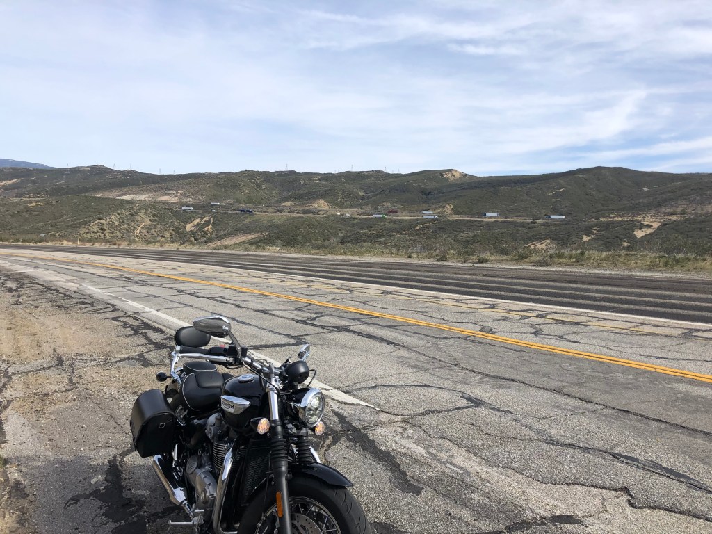
It turns out that most people place the boundary between northern and southern California much further south, with the Grapevine in Kern County being the epicenter of their choices. And when people talk about “the Grapevine,” what they usually mean is the stretch of Interstate 5 that crosses over the Tehachapi Mountains at Tejon Pass. A few points of clarification here: First, a southern Californian would call this freeway “the Five,” rather than “Interstate 5.” This phrasing, more than any geographical feature, marks the boundary between northern and southern California. If the locals refer to “the 101” or “the Ten” or “the Five,” you’re in southern California. I’ve noticed another reliable indicator is whether your local Subway restaurant includes cilantro within its range of produce. If so, you’re in southern California. I’m not making this up.

A second point about the Grapevine is that the name is mistakenly considered to be a reference to the twisting nature of the roadway. But it’s actually named for the wild grapes that have grown (and still grow) in the region. Still, you might wonder why anyone would believe that this multi-lane, relatively straight stretch of interstate traveled by big rigs at 70 miles per hour resembled a meandering grapevine. In fact, the comparison dates back to the original road over these mountains, which was a twisting two-lane road built in 1915. And that is the object of today’s travels.

Now let’s get something straight…

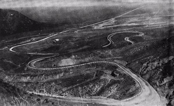
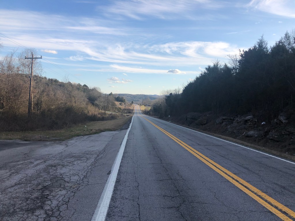
This original road, known as the Ridge Route, had been constructed to link the burgeoning Los Angeles basin to the rest of the state by way of the Central Valley. It was considered an impressive engineering feat at the time, with 697 curves and climbing to more than 4,000 feet above sea level. But the road, with its 15 miles-per-hour speed limit quickly became obsolete as road standards were raised to meet the demands of California’s fast-growing automobile culture. A straighter, three-lane “Ridge Route Alternate” was opened in the 1930s, followed by the US 99 highway in the 1950s and, finally, Interstate 5 in the late 1960s. By this time, the original ridge route was being used mainly for local traffic, and maintenance was severely cut back. Yet the road remains largely intact, and so this morning I hopped on the trusty Speedmaster and went out to see what I could see.

Now, the original ridge route runs 44 miles northward from Castaic to the town of Grapevine. And while you can still see the original road on a modern map, I’d been told conflicting stories about how truly accessible it is. This is a point I intended to clarify.

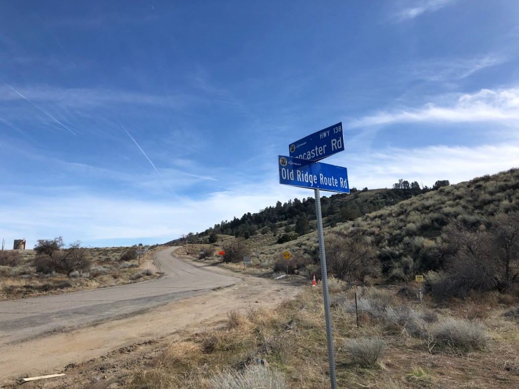
I rode up the interstate directly to the town of Grapevine, where I started looking for the ridge road. I spotted segments of what I assume to be the original roadway on the other side of some hills, but I kept failing in my attempts to find a way over to the elusive road. I jumped back onto “the Five” a couple of times to move a little further south, and tried again. Finally, while driving a stretch of Lancaster Road (Los Angeles County Highway 138), I found a turnoff for “Old Ridge Route Road.” Could it really be that easy?

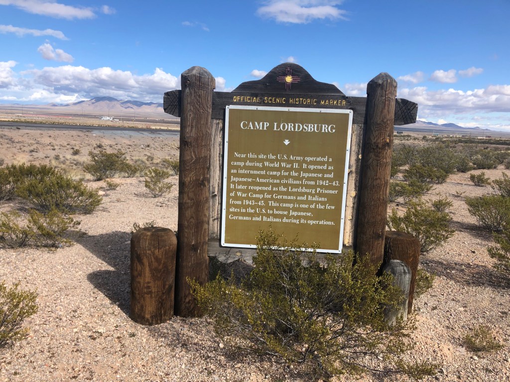
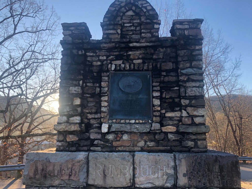
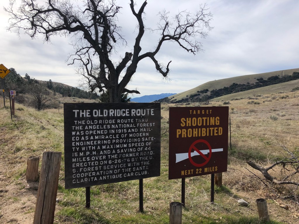
After traversing this road about a mile, I encountered a sign that confirmed I’d found the old, original ridge route:

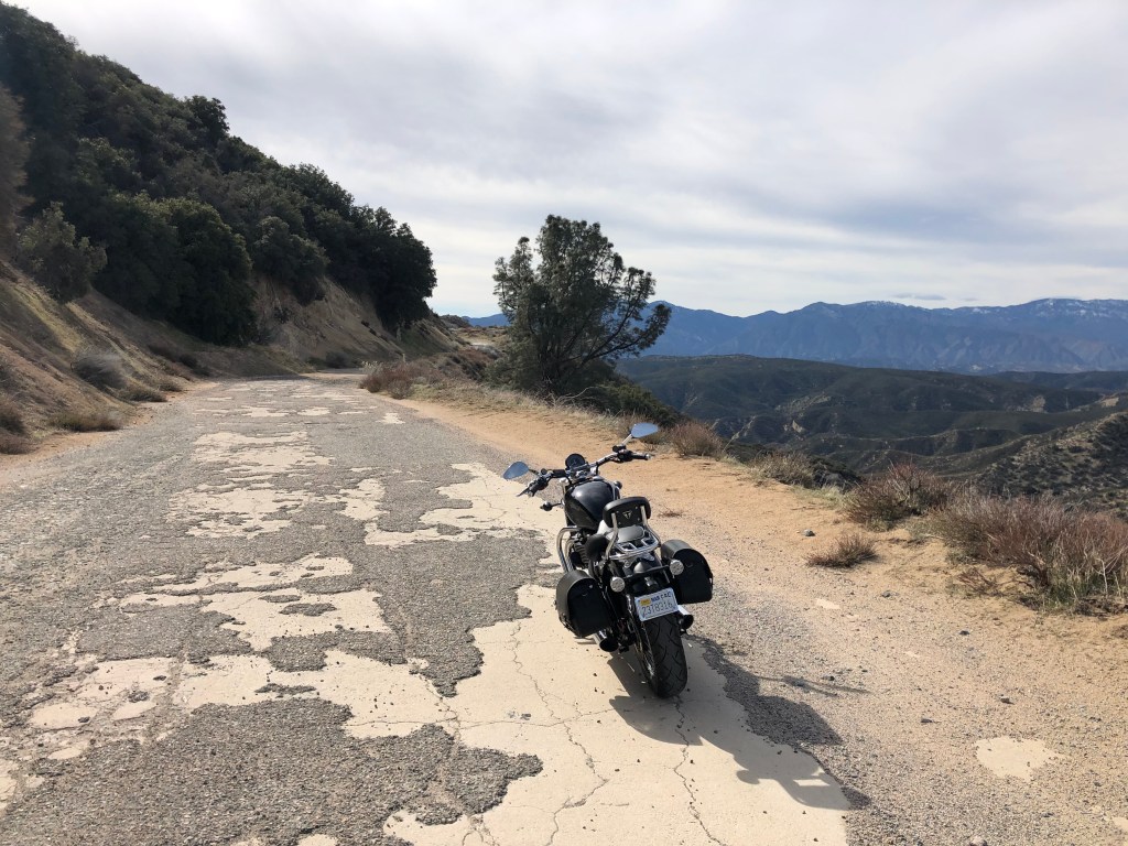
The route is no longer maintained by the county, and as I pushed forward the road got narrower, rutted, and strewn with rocks. I was forced by physics to stick with the original speed limit of 15 mph. Still, the concrete roadway was in remarkably good shape for 100 years old, and I imagined what it must have been like to drive a flivver along it back in the day.

They don’t call it the “ridge route” for nothing.

Only once was my safe travel along the roadway in question, where a mudslide had washed over the road during a recent rain. But the mud was now dry, and with my feet on the ground I walked the bike over this treacherous part. Not surprisingly, I encountered no one else on the road.

At one point I passed a sign indicating that Castaic (the southern end of the route) was 31 miles away. I began to think that perhaps I would be able to ride the entire length of the ridge route. I hadn’t seen any signs telling me that motor vehicles were prohibited, and I wasn’t about to go out of my way to find any such restrictions. Still, at 15 miles per hour, I had another couple of hours of bumpy riding ahead of me.

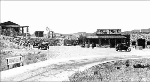
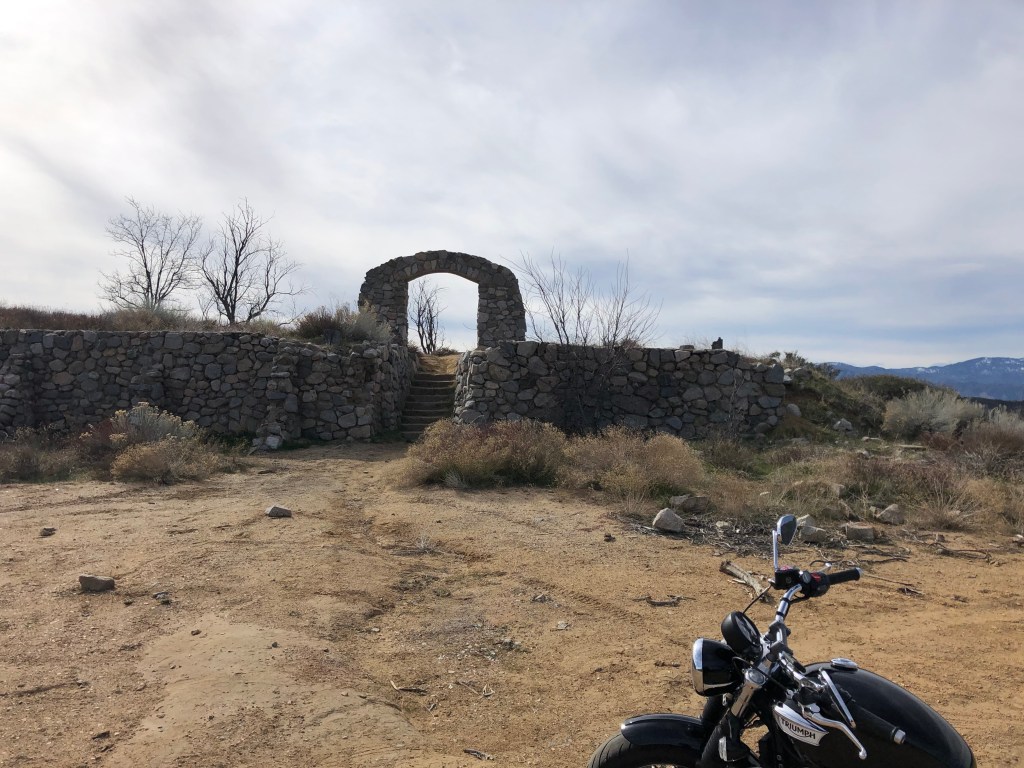
After a bit longer I rounded a corner to see the remains of the fabled Tumble Inn. It was constructed shortly after the Ridge Route opened in 1915, and included a Richfield filling station and a cafe at the road level. Walking up the cement steps and through a stone arch brought you to a lodge with views of the surrounding mountains. It was a welcome oasis along the slow, bumpy route. It closed in 1933, when the Ridge Route Alternate opened.

The Tumble Inn in its better days.
The Tumble Inn, after succumbing to its prophetic name.

After exploring the remains of the Tumble Inn and listening for the ghosts of pre-World War I auto travel, I jumped back on the Speedmaster to continue my leisurely ride along this historic road. But no sooner had I rounded the next corner than I encountered a large, sturdy gate with a sign prohibiting motor vehicles. Curses–Foiled again! I had no choice but to turn around and head back to Highway 138, whence I’d come.

I eventually got back onto I-5 and, while heading south, took a few exits to try to rejoin the ridge route. I failed in those attempts. I’ll spare you the gory details, except to note that, when I finally got to Castaic, which is the southern end of the Ridge Route, I did manage to find the old, original road. And so I began taking the route northward, knowing that at some point I’d have to encounter another barrier.

Southern portion of the Ridge Route. Note “the 5” in the background.

That barrier showed up much sooner than I’d expected. After fewer than 5 miles, I encountered a gate almost identical to the one that stopped me by the Tumble Inn. This one, however, was in the process of being closed by a security guard. I (somewhat foolishly) asked him if the road was open to traffic, and he told me, firmly, that it wasn’t. “Then why,” I asked, doing my best Columbo impersonation, “had it been open just a moment ago?” It was to let some workers through, he told me. They’re doing some work up at Pyramid Lake, and they’re really “paranoid” (his word) about “civilians” (also his word) in the area. And so, for the second time, I found myself backtracking on my journey.

When I got home I did a little research on the story of the Ridge Route’s closure. It’s a long and sordid tale, but the short version is this: In 2005 the Los Angeles County Board of Supervisors “vacated” the ridge route (presumably to avoid the costs of maintenance and the risk of liability). The road reverted to the US Forest Service, on whose land it travels. That same year, storms caused parts of the road to fail, and it was closed for safety reasons. Today, 15 years later, most of the road is still closed to vehicle traffic, because (a) no one maintains the road any longer, and/or (b) some portions are now private property, as a result of the Supervisors’ vacating of the easement. Whatever the reasons behind the closure to motor vehicles, however, the entire road officially remains open for hiking, biking and horseback riding. And I’m planning to take a mountain bike along part of the route later this spring. Anyone interested in joining me should let me know…

Uncategorized

From Sea To Shining Sea

This morning I left North Carolina’s outer banks and made the two and a half hour drive to Raleigh Durham airport. I wish I’d had more time to have spent at the Atlantic coast. The weather was glorious, considering it’s the middle of January. And the communities intrigued me. These Atlantic neighborhoods feel at once older and preoccupied than, say, Santa Cruz or Monterey or even San Diego. The buildings and people near the North Carolina coast feel like they belong there, while in California the built environment often seems to be locked in a fight for supremacy with the natural environment. And many of the people populating coastal California appear to be transplants, a little too pleased with themselves for having acquired a piece of this scarce real estate.

So now, in the words of John Denver, I’m leaving on a jet plane. Don’t know when I’ll be back again. But in the meantime I’m reflecting on the trip and what I’ve learned. My thoughts can be grouped into three themes.

The first concerns the vastness of this country. It took eight long days of driving to get from one end to the other. All told I traveled some 3,320 miles, which is almost 1,000 miles more than the 2,381 that’s advertised for Route 70. Of course, I did rack up mileage at the front end (from Los Angles to the start of US 70 in Globe, AZ); I also took numerous short side trips to explore nearby points of interest; and I had to double back to Raleigh to drop off the rental car and board my return flight. US 70 zig zags some on its way across the continent, but generally it made a continual push eastward. The final stretch to the shore seemed to take forever. A look at a map reveals just how far the highway pushes toward the ocean. No wonder that the waiter at Tight Lines Brewing last night called the town of Atlantic “the end of the world.”

“The end of the world.” –Kenny

My second group of thoughts concerns how much, and how rapidly, the physical environment along this route changes mile by mile and state by state. While driving US 70, the car cuts through a continuum of different weather, topography, flora and fauna. I traveled through the dusty deserts of Arizona and New Mexico, along the expansive plains of Texas and Oklahoma, over the hills of Arkansas and the mountains of Tennesee, until lfinally arriving at the rocky shores of the Alantic Ocean. As should be evident from my musings and photos over the past week, the towns and buildings along the route also differed greatly from each other, from the eerie desolation of Paducah to the modest charm of Dickson to the urban blight of West Memphis. This broad variegation of the road’s surroundings in part makes the uniformity of US 70’s signage so comfortable and reassuring.

Finally, and perhaps most importantly, I keep thinking about the people I met on this drive. Just like the physical environment, the demographics and culture of the people changed along the way. The desert people were mainly white, Native American, and Latino, and many of them displayed physical and psychological features that had been weathered. The Texans seemed to be moving at ¾ speed, and the Arkansans all seemed to be wearing camouflage. The communities of Tennessee appeared to be more segregated that those of its western neighbors. Sure, there were many exceptions to these stereotypes, but the differences between each region’s residents were palpable. Regional accents were especially noticeable when moving across the entire country in a week. It’s uncanny to have lunch in one town, get back on the road for a few hours, and by dinnertime the local conversations are spoken with a different accent.

But the other remarkable quality about the people I encountered is their damn decency. I know I’ve made similar observations about this on earlier road trips, but it bears repeating. For all the conflict and hostility and partisanship and tribalism and rudeness that seem to characterize the national conversation, I find that, one-on-one, Americans are good-natured, generous, and caring. This isn’t just something I saw in restaurant wait staff, whose civility might cynically be attributed to tip-fishing. I also regularly encountered courtesy and kindness from people I met on the street from whom I asked directions, and from the two guys asking for a ride over Apache summit, and even from the young dental student who got into a crash with me in Memphis. (What’s that? I didn’t mention this in the blog? Ah, well, I thought it would disrupt the narrative. Rest assured that the accident was minor, and no one was hurt.) Somehow it’s reassuring that two strangers can crash their cars, and then spend the next 15 minutes talking about career plans and road trips while waiting for the cop to show up. 

So, I return to California not exactly a changed man, but I’m definitely more optimistic about our country.

May all your days be circus days.

DELETED SCENES AND OTHER BONUS MATERIAL

I leave you with some additional items that didn’t make it into the blog.

First, for those of you with way too much time on your hands, you may want to check out the short-lived Casey Jones television series from the late 1950s. It stars Alan Hale, who seven or eight years later would go on to play the Skipper on Gilligan’s Island.

If you’re intrigued by the (near-) ghost town of Paducah, TX, you may want to watch this 10 minute very amateur video of the abandoned buildings.

If Billy the Kid and/or Paul Newman are your thing, did you know the latter played the former in a 1958 movie?

Finally, here are some additional photos from the trip:

Studebaker-On-a-Stick, in Waverly, TN.
Moby Catfish.
Neat mailbox idea in Alexandria, TN. Brian W identifies it to be a 1968 Honda CL90 Scrambler.
Seems to be the preferred spelling of Barbecue. Also,this establishment is supposed to be the favorite restaurant where Bill Clinton got his fix. Of barbecue, that is.
Arrow art in Paducah, TX, commemorating the Comanche Chief Quanah Parker Trail.
Another arrow from the same set of trail markers, this time in Paducah, TX. Aren’t I hilarious?
Barbie firetruck?
The old pharmacy building in New Bern, NC, where Caleb Bradham invented a drink that became marketed as Pepsi starting in 1898.
Cute name for a nursery. Sadly, it recently went bankrupt. In Morgantown, NC.
At some point, graffiti becomes a historic artifact. On the inside wall of the train station in Old Fort, NC.
You probably guessed that my attention was arrested by the misplaced apostrophe. But I actually am mystified by the wording. It suggests that the “things” are in addition to the shop itself. I would have phrased it as “Snacks and Things.”
Now, this phrasing is beyond remedy.
Cool goat art in Palestine, TN.
They go together like apple pie and cyanide.
Elevator that once served a hotel in Ardmore, OK is now inexplicably on display outdoors near the train station.
Chickenmobile at Heidi’s Cloverleaf store in Ardmore, OK
Roswell, of course.
I just thought this was really well done. In Ruidoso, NM.
Lordsburg, NM is another place where Japanese Americans were interned during World War II. In this case, they were housed with German and Italian POWs.
New Mexico’s DOT really keeps a fine-grained accounting of their spending.
I didn’t stay here. I’m told the rooms are too hot. Har.


Uncategorized

End of the Line

Today’s travels began in eastern Tennessee. The drive was quiet and scenic, crossing Douglas Lake, with all its fjord, snaking through the Appalachians, and crossing the French Broad River . The bridge over said river in Cocke County is especially picturesque. I’m always struck by how graceful these old bridges are. That’s one of the advantages of taking these lesser highways; the old bridges haven’t been replaced with 6-lane monstrosities. This bridge is called the Wolf Creek Bridge. Which makes you wonder, since it crosses the French Broad River.

She’s a beauty.
Insert obvious joke here.

Now, remember at the beginning of this trip, when I said that US 70 was sometimes called the Lee Highway, as a counterpoint to the northern Lincoln Highway? I hadn’t seen any evidence of the Lee designation along my long drive. Along the way I noticed signs calling it different names, from The Old West Highway in Arizona, to the Gold Star highway in Arkansas, to various veterans memorial formulations in Tennessee.

No mention of Mr. Lee out west…

But then, this morning in North Carolina, I encountered a marker “in loving memory of Robert E. Lee,” and dubbing this stretch of road the Dixie Highway.

Erected and dedicated by the united daughters of the confederacy and friends
In loving memory of Robert E. Lee and to mark the route of the Dixie Highway.
“The shaft memorial and highway straight attest his worth — he cometh to his own. –Littlefield
Erected 1926

So. I guess I’m in the old confederacy now.

A little later I found a reference to a “geyser” that was reputed to exist over small pass. I turned onto the narrow road, and went up into the hills. Soon I was at what appeared to be a large fountain poured out of concrete.

Thar she doesn’t blow!

Signage on the site tells an story about his “geyser.” It was originally constructed as a tourist attraction in 1885 by the owners of a nearby resort hotel. The fountain, fed by a buried pipe conducting water from a pond higher in the mountains, reputedly shot about 80 feet in the air. After the hotel burned down in 1903, the geyser fell into disrepair. Then a railroad and banking magnate named George Fisher Baker paid to have the geyser restored. It was he who is responsible for the existing cement basin. (Notably, Baker was considered to be the third richest man in America, after Henry Ford and John D. Rockefeller.) Alas, even after another restoration in the 1970s, the geyser appears to again be dry. I’m told by locals that the water supply has dried up, and there is talk of installing a new pump.

This spout clearly hasn’t seen any water since the last rainstorm.

Not to long after my disappointing “geyser” experience I came upon a railroad depot in the town of Old Fort,NC (population: 908). The depot was originally built in 1881 to serve the Western North Carolina Railroad. Passenger service ceased in 1975, after which the building was eventually fully restored. Today the depot serves as a museum, as well as a real estate office. The 140-year-old (!) architecture is beautiful, and I’m impressed with the quality of the restoration.

Could someone please take down the Christmas lights?

Now, there are two ways to organize a museum: with everything carefully protected behind glass and velvet ropes, or with artifacts out in the open, as they would have been encountered back in the day. This museum has employed the latter approach, and it very much allowed me to feel as though I’d stepped back in time. The telegraph room, looking out through the bay window at the tracks, was superb.

Look carefully at the telegraph sounder, near the middle. Prince Albert’s in a can!

OK, one more station–this one in Marion, NC (pop: 7,800). This freight depot was originally built in 1867, to serve the same Western North Carolina Railroad mentioned above. Over the years the building was expanded, then fell into disrepair, and finally was restored, serving today as an event venue. Again: What explains why some of these old buildings get lovingly restored, and others are neglected or razed?

There’s a three little pigs quality to this depot…

Eventually I found myself in North Carolina’s capital city of Raleigh (pop: 465,000). I was running behind schedule, so I only stopped long enough to refuel the car and engage is a bit of flagellation.

Ain’t that a kick in the…

Back on the road, the sun was dipping behind the hills as I got closer to the coast. It’s remarkable how you can sense the presence of the ocean without even seeing it. It’s evident in the smell and feel of the air, and the change in vegetation, and the price of the gasoline.

Soon I was driving through the Outer Banks, with its archipelagos, inlets, and spits. The highway took on one final name change: the Outer Banks National Scenic Byway. By this time the sun had set, but an almost-full moon illuminated the landscape. It was an eerie scene, driving though this mostly deserted country in the moonlit darkness, with the outlines of leafless trees overhead and the moon reflected on the water. I’m sure the drive would have been beautiful during the day. (See a stock photo of Atlantic, NC, below.) But the evening drive had its own beauty, I wish I could have captured it with my camera, though.

What Atlantic, NC looks like during the day. Or so I’m told.
My view of Atlantic, NC this evening.

So, having arrived in Atlantic (population: 543), I was at the end of my journey. I had succeeded in driving the 2,381 miles of US Route 70.

Somebody get this man a razor.

All that was left was to have a celebratory beer. But the town of Atlantic is Nowheresville. It appears not to possess a single restaurant, or any other business for that matter. It seems to be almost strictly residential. And even the homes all seemed to be dark. It’s as though I’d stumbled upon another ghost town.

So I backtracked on US 70 about 40 miles to Morehead City (population: 8,660), where I found a local brewery by the name of Tight Lines Pub and Brewing. The place first opened in 2014, but it closed temporarily in September 2018 when Hurricane Florence destroyed the roof. The place didn’t reopen until just a few months ago. My waiter, Kenny, told me that the building just celebrated its 100th anniversary.

Kenny gives my road trip two thumbs up!

Anyway, Tight Lines had over a dozen of its own beers on tap. I told Kenny I was in a celebrating mood, and wanted something dark and heavy. He brought me their “Small Craft Advisory Stout.” It’s oak aged (though not bourbon barrel aged), with 7.7 percent ABV. It’s lightly carbonated and lightly hopped, and doesn’t have a lot of complexity. This is a very mellow beer, with oatmeal notes dominating. I wouldn’t consider it to be a “celebration” kind of beer. But it went down easy enough. An undramatic end to a fun, but thankfully undramatic, trip.

Uncategorized

I Fall To Pieces

Soon after getting on the road this morning, I spotted a historic marker near Camden, TN, commemorating “One of Country Music’s Darkest Days.” Stopping to read the sign, I learned that Patsy Cline, her manager, and two other musicians were killed on March 5, 1963 when their plane crashed near this spot.

The other day that the music died.

A winding gravel path led down the hill to the spot itself. So I locked the trusty Ford and made my way through tall birch trees, taking in the still morning air. It was good to be out in nature, hearing nothing but the occasional bird.

Could you birds keep it down please?

Soon I came to a clearing, fitted with a couple of benches, and in the center was a simple rock memorial marking the location of the plane crash. I found myself strangely moved, in this quiet grove in the middle of winter in rural Tennessee. I reflected a bit on Patsy Cline, only a few of whose songs I know. But it must have been a horrific ending to such a gifted life. Some people had left coins on the rock, and I reached into my pocket and found that I had exactly four pennies. One for each of the people killed in the crash.

“On this site March 5, 1963 Patsy Cline, Cowboy Copas, Hankshaw Hawkins, Randy Hughes lost their lives in a plane crash. In loving memory July 6, 1996”

I realize there seems to be a lot of untimely deaths showing up on this trip–Patsy Cline, Casey Jones, even Billy the Kid (or, more appropriately, his victims). But some of the towns I’ve encountered also seem to have experienced death, or are facing it. Why is this? What causes a working, living town to become a ghost town? Part of it of course owes to a reversal of economic fortunes. The gold rush boom towns were especially susceptible to this. But what about places like Paducah, TX (highlighted on Jan 4?) What caused it to decline? Where did everyone go? Why did they walk away from homes, businesses, major hotels, and other properties?

Or why is there a huge abandoned parking lot in town of Burns, TN, that I passed today? I suppose that’s a fairly easy question to answer: It had been a drive-in, and people stopped going to drive-ins all across the country many years ago.

Now showing: Field of Dreams

But the question, to me, isn’t why the drive-in died; rather, it’s why was it a thing to begin with? Why would people think that parking their cars in a huge lot and watching the movie through their windshields, projected on a distant screen, with the sound coming through a tinny, scratchy speaker, would be enjoyable? Especially with all the distractions from the other cars that invariably flash their lights and drive in and out of the parking lot. Why would this be preferable to the old-fashioned idea of sitting in a comfortable seat in a golden-age Movie Palace with cute usherettes offering you gum, candy, and popcorn? (I do understand that a teenager on a date might find something to recommend the car-based seating.)

But to return to the Declining Towns Hypothesis: It’s not the case that towns just have a natural lifespan, and eventually die of old age. There are plenty of American towns that have survived, and even thrived well into their second century. Take the example of Dickson, TN (Population: 14, 500), which I drove through this morning. Dickson is a clean, attractive, appealing town. It’s not bustling exactly, but it’s definitely active. I drove down the main street and stopped for coffee at “House Blend,” which is one of those hipster places in a building that dates back to the Roosevelt Administration.

This sculpture in front of House Blend made me smile.

Driving around the town, I saw other evidence of its well-being. I count public art as one such indicator.

Not as cute as the little coffee guy, but whimsical enough
Sign on the side of a restored ice cream fountain.
The fountain in question.

Even this unrestored building exuded an atmosphere of activity. It’s well worn, but not decaying. it’s earned its wrinkles.

A sign on the door says that they have live music every Saturday.

(Later I discovered a few clues about how Dickson has been able to prosper while other small towns along US 70 are dying: Partly it’s because Dickson is located not just on US 70, but it’s reasonably close to the Interstate (I-40). It’s also within the gravitational pull of Nashville, which is about 45 minutes away. And it has a community college. So, maybe it has some unfair advantages.)

A little later I arrived at the capital of the Volunteer State. As alert readers know, bigger cities are not the focus of this trip. But Nashville (population: 668,000), known as “Music City,” does have one compelling feature to recommend it. And that, of course, is that it’s the site of the country’s worst railroad disaster. It happened at “Dutchman’s Curve” on July 9, 1918, when two passenger trains collided head-on. Over 100 people died. It gives a good illustration of the disaster that could have been, but which Casey Jones had prevented, some 18 years earlier. Anyway, I walked a bike/walking path for a mile or so to arrive at the site of the crash. The piers of the railroad bridge, which had been originally constructed during the Civil War, are still in place.

Part of the path to the crash site. I suppose that local officials worry that the 1918 disaster at Dutchman’s Curve could be re-enacted by bicycle riders.

After that welcome walk, I got back onto the familiar pavement of US 70. Since it was almost noon and I was in the Big City, I found myself a proper brew pub in the form of M.L. Rose Craft Beer and Burgers. So, let’s do the:

BREW OF THE DAY

I ordered up a Blackstone Black Belle Imperial Stout to go with my awesome BLT sandwich. Blackstone is a local brewery, and their imperial stout is aged in used barrels that had contained Nashville’s Belle Mead Bourbon. Blackstone’s stout is a “high gravity” beer, with an ABV of 13.5 percent. (That’s why it’s served in a small glass. )

I’m in love.

It has the color and consistency of used motor oil, but the taste is considerably better than that. It’s amazing, stupendous. Rich, sweet, woody. An explosion of flavors–chocolate, maple syrup, maybe some sweetened oatmeal. The sweet hits the front of your tongue, and something more fermented is registered on the back sides of your tongue. As I recall, that’s where our sour receptors are, but this doesn’t really have any sour notes. A little hoppy bitterness perhaps, but mainly malty and whisky flavors. It’s like drinking a big, hot, loaded pastrami sandwich with sweet mustard that’s spent a week in a smoker, soaked in Aunt Jemima, and drizzled with chocolate sauce and bourbon. It was worth the drive from Los Angeles to experience this.

So, why don’t you guess what I saw before I left Nashville, given my consumption of this high-alcohol beer? Yes, it was another of the pachyderms that I’m beginning to think are the unofficial mascot of US Route 70. You can bet I was on the lookout for a sobriety checkpoint afterwards…

Another day on US 70, another pink elephant.

After leaving Nashville, US 70 soon began to rise and twist up toward the Appalachians. The drive was relaxing, the weather was beautiful, I had Patsy Cline on the stereo.

All is right with the world.

Tonight I’m in Knoxville, getting close to the state line . But before we enter North Carolina, I have one more item from the Volunteer State:

When I was driving through the town of Mason, TN, I saw a sign for Bozo’s Hot Pit Bar-B-Q Restaurant. (I’ve been told that there’s a difference between BBQ and Barbecue, but I’m not sure where Bar-B-Q fits in.)

Anyway, the sight of that sign nagged at me, triggering a memory of something I’d heard about a place in the south that got sued by Larry Harmon (TV’s Bozo) for infringing on his trademark. A quick internet search confirmed that this was that place! It seems that a fellow named Thomas Jefferson Williams was born in Tipton County, Tennessee, in 1876. Somehow, he was given the nickname “Bozo” which stuck with him until his death in 1935. Bozo Williams opened his Bar-B-Q restaurant on Highway 70 when that stretch of highway was completed in 1925. Years later, in 1982. Bozo’s daughter, who now owned the place, thought she’d open a second restaurant, and decided to apply for a trademark for the restaurant’s name. So far, so good.

But Larry Harmon, who’d performed as Bozo the Clown since the 1950s, wasn’t having any of this. He thought that he should the only person permitted to use the name Bozo for business purposes. He challenged the daughter’s trademark attempt, but her trademark was granted by the government. Harmon appealed to the US Court of Appeals, which upheld her trademark. Harmon then took the case to the US Supreme Court, but the Court in 1991 refused to hear the case. “Bozo” Williams’ family had won. I’m happy for the outcome, but wouldn’t it have been great if the Rehnquist court issued an opinion on Bozo v. Bozo?

And so it is that the restaurant, begun in 1925, still sits on US 70, and still brings in crowds from all over the country. Maybe somewhere in that story is the secret to keeping a town alive.

Uncategorized

Come, all you rounders…

This morning I left my motel early and got back on US 70, which now feels like an old friend. As I passed through the rolling hills of eastern Arkansas I spotted an old caboose set back from the road. (I suppose all cabooses are “old” at this point, since all the major American railroads stopped using them in the 1980s.)

Turning off the road toward the caboose, I came upon a large brick building that advertised itself as the Central Delta Depot and Museum. It didn’t look like your typical train depot; it was far too stately, more like an old library or courthouse. I decided to take a quick walk around to see what this place was exactly. It was only about 7 am, and the place was locked up tight. I peered in the windows, and then took a walk around the back to see if I could find evidence of railroad tracks.

Impressive building. But a judicious application of Scott’s fertilizer wouldn’t hurt.

The back of the building was fairly nondescript, and it didn’t have the usual freight loading facilities or other aspects of a traditional train station. As I came around the corner and returned to the front, I encountered a man of a certain age, sporting a neatly-trimmed white beard and a bomber jacket. He had just stepped out of his car and was approaching me. “Can I help you?” he asked. Worried that he assumed I was engaged in early-morning trespassing (akin to my behavior at the graveyard the prior morning), I launched into my monologue about traveling US 70 and stopping at anything that interests me. “And your depot really interests me,” I said, a little too enthusiastically, hoping to soften him up with praise. He looked at me for a long moment, then seemed to relax. “I’m Bill,” he said, holding out his hand. “I’m the museum director.” I observed that he sure came to work early. “I don’t have a lot else to do,” he replied, with a tinge of regret.

Museum Director Bill.

Just as I thought the conversation was over, his eyes fixed on me again. “So you’re driving Route 70? The whole thing?” This is the first person on the trip who showed any real interest in my road trip. We started talking about key railroad towns on my route when he suddenly interrupted himself and said “would you like to come inside?”

For the next hour Bill gave me a guided tour of the museum/depot. It turns out that the building was built for the Rock Island Railroad in 1912. The building is located in Brinkley, AR (population: 2,700) which is about halfway between Little Rock and Memphis. Bill considers it to be the most visually striking depot in the region. The building had been restored in 2003, when it reopened as a museum. Bill was made the museum director, a post he has held to this day. He takes great pride in the museum, which hold an eclectic combination of artifacts related to blues music, textile arts, airplanes, photography, nature, and of course railroads. But to me, it’s the inside of the structure itself that’s remarkable. They did a first-class job of restoring the building, with its high ceilings, hardwood floors, and many windows. Bill’s only regret is that they didn’t retain the doors to the “colored” and “white” waiting rooms. He thought (and I agree) that it would have served as a good reminder of the segregation that existed for so long in this part of the country. But evidently the museum board didn’t want anyone to be offended by them.

As the morning wore on, Bill shared some of his personal life. He was born just about 15 miles from the museum, and still lives in the same house he was born in 76 years ago. He hasn’t lived there continuously, though, since he’d spent some 25 Corpus Christi, TX, before returning. He wishes he could go back to Texas for one more visit before he dies, but doesn’t think he could afford the trip.

Bill got visibly upset when talking about the current, national political climate, and also sounded rueful when he observed that the town of Brinkley is dying. “The population is about half what it once was. And few of the townspeople ever come here to the museum. They don’t have much interest in it.” I asked how many visitors he gets on a typical day. “Sometimes I don’t see anyone all day.” He went quiet, his mind occupied with, what? The town of Brinkley? The state of politics? His desire to go back to Corpus Christi? “It’s sad,” he said finally. And after a bit more silence as the gears turned in his head, he opened his mouth and said, “Over here is a poster of the ivory-billed woodpecker…”

Eventually it was time for me to get back on the road, and I thanked Bill for the personal tour. “You’ve done me a favor. I enjoy talking about this stuff.” It must be frustrating to have a passion for history, to have learned so much about your subject and curated this enormous collection of local history, which is housed in a beautifully restored, 100 year old building….and not be able to share that with anyone on most days.

Not too long after leaving Brinkley I was crossing the mighty Mississippi River and entering Memphis, Tennessee (population: 650,000). The bridge that sends US 70 over the river is older and, to me, more impressive than the bridge that the interstate (I-40) uses a few miles to the north.

US 70 crossing the Mississippi.

I took a brief walk along the waterfront, and encountered this sculpture of a dramatic rescue of 32 survivors from a capsized river boat in 1925. The man doing the rescuing is Tom Lee, an African American resident who, though he couldn’t swim, repeatedly took his small boat out on the river to rescue survivors one by one.

Since I was in Memphis, I made a point to visit the Stax Records Museum. Until the last year or so all I knew about Stax is that they were the label for Booker T and the MGs. My dad had one of their records when I was growing up, and it was probably the only reasonably “hip” record in our household. You know the MG’s music, even if you don’t know them as a band. A couple of the musicians went on to become members of the Blue Brothers band (with John Belushi and Dan Akroid) in the 1970s. Stax was never a huge label in terms of gross receipts, but they sure had some influential R and B acts: in addition to Booker T and the MGs, Stax recorded Otis Redding, Sam and Dave, Isaac Hayes, Albert King, Wilson Picket…. the list goes on. It’s Stax that defined the “Memphis sound.”

Anyway, last year Karen and I saw Booker T Jones (front man of the MGs) perform with a band of all-stars at the Hollywood Bowl. I enjoyed it immensely. It was the 1960s all over again. Booker T was charming and he hadn’t lost his musical touch. Then, a few months later, Booker T released an autobiography and went on a book tour. We saw him give a talk about his book at an intimate venue in Los Angeles, and again he was charming and thoughtful and accomplished. I read the book last November, and in addition to describing Booker’s life it presented a lot of history about Stax. You should read the book if this kind of thing interests you, but all I’ll say here is that Stax was created on a shoestring, and the recording studio and offices were in an old movie theater east of the downtown. It’s amazing how much influence came from such a modest venue. The building was eventually razed after Stax went out of business in 1976, But it was eventually rebuilt just as it had been, and it reopened as a museum in 2003. It was this building that I drove through some sketchy neighborhoods to see.

Stax, reborn.

Unfortunately, Monday (today) is the only day that the museum is closed, so I was unable to go in. But there was something remarkable about being at the very grounds where that musical magic was worked. Do yourself a favor a play a little of the Memphis Sound for yourself on YouTube tonight.

I got back onto US 70, and soon left the hustle and bustle of Memphis behind me. I do like Memphis, but this trip is meant to explore the small, forgotten towns across the country. Memphis needs to be experienced when I have a few days at my disposal, and when I’m prepared to stay up late listening to music and abusing my liver with cocktails.

The highway continued to wind through the gently rolling landscape of western Tennessee, and I eventually found myself in the town of Jackson (population: 67,000). As you may or may not know, Jackson was the adopted home of Casey Jones.

Now, Casey Jones, along with Sherlock Holmes, are historical figures who most Americans aren’t quite certain whether they were real or not. I’m here to assure you that Casey Jones was very real. He was born John Luther Jones in 1864, and grew up in Cayce, KY. When he moved to Jackson, TN, people started calling him “Casey,” in reference to the Kentucky town he hailed from. He loved railroads and began to work for them as a teenager. He eventually became an engineer (at age 26!) and was renowned among railmen as one of the most reliable engineers to keep a schedule. But then, on April 29, 1900, he was killed when he heroically remained at the controls to try to stop his locomotive before it hit a stalled train ahead. All that stuff you know from the Casey Jones song is essentially true; he slowed the train sufficiently to prevent any deaths of passengers, and he did tell his fireman, Simeon “Sim” Webb, to jump just before the crash. Sim survived, and lived another 57 years to tell the tale.

Much of this I learned from the Casey Jones Museum in Jackson. It contains an impressive collection of memorabilia related to Casey Jones, Sim Webb, their families, and railroading in general. Among the artifacts that are most likely still haunted by Casey are these:

His pocket watch, recovered from the crash undamaged. Casey was proud of the watch, and reportedly would tell people the time to the second when asked.
His home. Believe it or not, the city bought the home Casey had lived in with his wife and children, and moved it next door to the museum building.
The horse-drawn hearse that carried his body to the graveyard.

The museum also has a locomotive that’s been renumbered to match Casey Jones’ engine (except this is not Casey’s actual locomotive, which was destroyed in the crash). It looks the same, though.

After leaving the museum, I made a visit to Mount Calvary Cemetery, where Casey Jones is buried. A plaque at the front gates announces the famous resident:

But what’s this? Another locked cemetery gate! A sign informed me that the cemetery is only open on Sundays, but it also noted that I could get the key from the local church office. Wanting to remain on the right side of the law, this I did, and soon I was paying homage at the gravesite of John Luther “Casey” Jones.

What. A. Guy.

Overall, it was quite a pilgrimage to Jackson. There’s something very powerful about encountering the tangible relics of a historic figure. I had a similar feeling when I worked in Washington, DC and daily would pass by a glass case at the Library of Congress which contained the contents of Abraham Lincoln’s pockets on the night he was assassinated. I guess that’s part of why I take these trips. Somehow being in these places and seeing these artifacts conveys truths and feelings and context that simply doesn’t come through on the printed page.

BREW OF THE DAY

No BOTD today. There was not a single craft beer joint along today’s route (with the exception of Memphis, but it was too early in the morning when I was there). I think paucity of good brews is one of the hazards of traveling off the beaten path in the south.