
For the past six months I’ve been editing my late grandmother’s unpublished memoir, with the goal of having it posthumously published. In the course of that work, I’ve burrowed into that gargantuan rabbit hole known as Ancestry.com, digging up ancestors (figuratively) and realizing the innumerable questions I should have asked Grandma while she was alive. As a result of this overdue epiphany, I’ve resolved henceforth to be better about connecting with my existing relatives, learning the family stories, and passing along family lore.
It’s for this reason that I’m currently on a plane to Vermont, to spend some time with my dad’s half-sister and my cousins–people I didn’t even know existed until a few years ago. (I’ve mentioned this long-lost branch of the family in an earlier post, and discuss it in more detail in my memoir.)
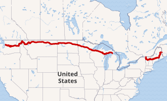
Anyway, the reason I raise all this is because Cousin Bonnie lives just off US Route 2, which is the country’s northernmost transcontinental route. Route 2 runs from Everett, Washington to Houlton, Maine, flirting dangerously with the Canadian border for most of the route. (For this reason it’s sometimes called “The Highline.”) Route 2 is actually a discontiguous highway, with the great lakes creating a watery lacuna between St. Ignace, MI and Rouses Point, NY. Observe:
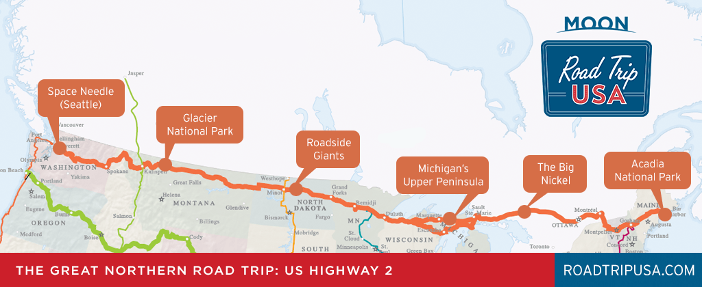
Cousin Bonnie lives near the western edge of the eastern segment of Route 2 (got that?), in Vermont. So, I figured that rather than fly home after visiting her, why not rent a car and drive home along Route 2’s western segment, from Michigan to the west coast? (There’s actually a number of good answers to that question, but I’m ignoring them for now.) The route has a lot going for it:
–It generally follows the route of the historic Great Northern Railway (today’s Burlington Northern and Santa Fe Railway).
–It passes through seven states and covers 2,100 miles
–It’s a historic auto trail that began as the Theodore Roosevelt International Highway in 1919.
–It will likely be unnecessary to run the air conditioner
So, I’ve decided to add Route 2 to my collection of transcontinental US highway trips, which so far includes US Routes 50, 60, and 70. Astute observers will note that all those transcontinental routes are numbered as multiples of 10, with the numbers becoming smaller as you move from south to north. (For those desiring a refresher on the numbering convention, look here. Highway nerds should look here.)
Anyway, US Route 2 runs to the north of US Route 10, so the numbering convention would have required that it be deemed “Route 0.” The feds evidently thought that was too weird, and decided instead to call it Route 2. For real.
Anyway, having decided to traverse the country on Route 2, the key question confronting me was: How should I traverse the Great Lakes Lacuna and arrive at St. Ignace, MI? The most direct route would be to cut through Canada, but I’ve opted instead to cut under Lake Superior and Lake Erie, and come up through Michigan. My logic is that a good friend from graduate school, Ross, lives just north of the New York City metropolitan area, and a former neighbor who’s also a good friend–Pam–now lives in Ohio on the south shore of Lake Erie. So I’ve planned a route that takes me by both of their homes…whether they like it or not.
My plan is to arrive at the eastern end of Route 2’s western segment (in St. Ignace, Michigan) on Sunday eve. Then I’ll be making daily posts of my trip for the following eight days, at which point I will arrive in Everett, WA. You won’t want to miss any of my reports! If you haven’t already done so, you can sign up to receive my blogs immediately below:
