Ghost stories · Road trips · trains

I do believe in spooks! I do, I do, I do….

Just a dandy lion.

So much for my grand plan of escaping the wintry weather by taking a southern road trip. It’s been raining cats and dogs all day.

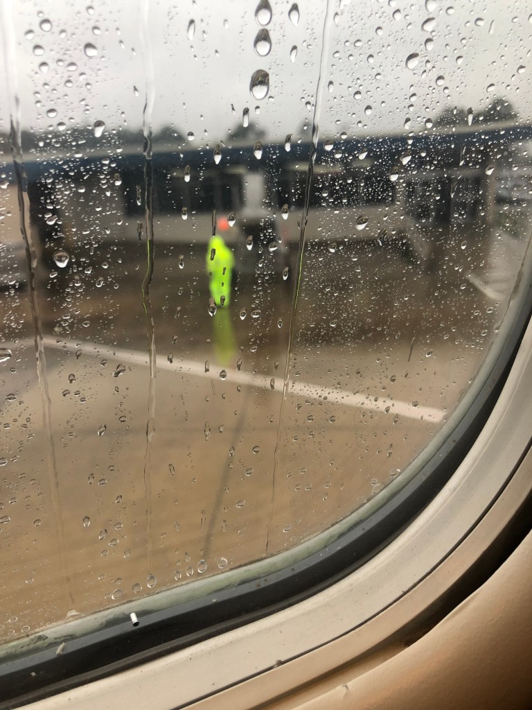
I knew something was up when I was on the second leg of my flight (from DFW to Texarkana). At our scheduled arrival time we found ourselves circling for three-quarters of an hour over thick fog and rain. Thankfully, the pilot of our tiny plane (there were only about 20 of us on board) handled the tiny plane as well as could be hoped. The whole situation reminded me of Gilligan’s Island; if not for the courage of our fearless crew, the airplane would be lost.

Anyway, we finally landed at Texarkana, which appears to be world’s smallest airport. Seriously. This airport does not seem designed to handle commercial aircraft. I think there’s just one runway. And some unfortunate employee had to literally wrestle the (apparently only) deplaning ramp into position by hand in the rain. When we made it across the small patch of tarmac and entered the tiny building, I practically bumped into the (single) car rental counter that is squeezed into an inadequate space next to the baggage claim. On the positive side, their single rental car was parked right next to the door. I was off in a flash!

Welcome to Texarkana.

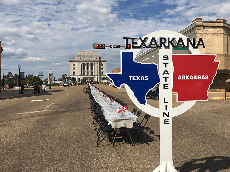
There are actually two Texarkanas, which togetherstraddle the boundary between Texas and Arkansas. Texarkana, Arkansas (pop: 30,000) sits on the Arkansas side, of course, and hosts the Lilliputian airport. Its sister city of Texarkana, Texas (pop: 36,000) is in the Lone Star state. The two Texarkanas combine into a large metropolitan area with a population of almost 150,000.

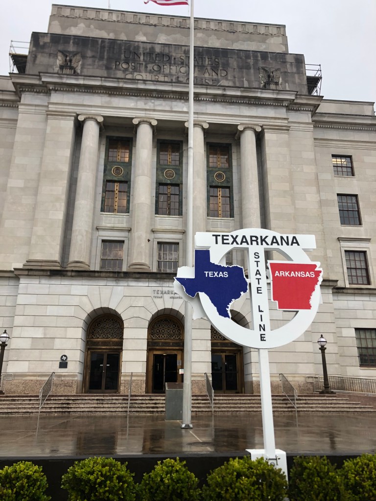
Before heading out onto Route 82 I spent a little time exploring Texarkana’s downtown core. One of the most prominent features is an imposing federal courthouse/post office building that sits squarely on the state line. Half the building resides in Texas and half in Arkansas. There’s a sign out front that helpfully commemorates that fact.

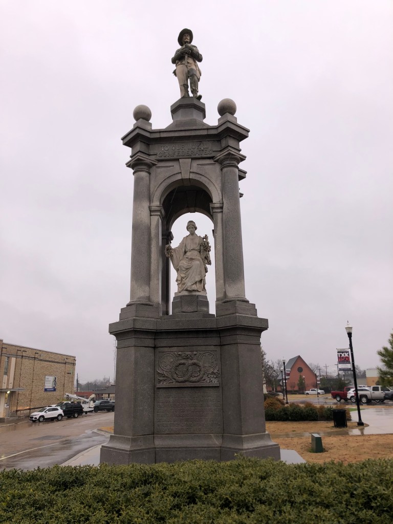
Speaking of commemoration, I spotted this nearby monument to the mothers of Confederate soldiers. Clearly I’m not in Kansas anymore.

Inscription on the base: “O Great Confederate Mothers, we would print your names on monuments, that men may read them as the years go by and tribute pay to you, who bore and nurtured hero sons and gave them solace on that darkest hour, when they came home with broken swords and guns”.

The two Texarkanas were established in 1874 (in Texas) and 1880 (in Arkansas) at an important intersection of several railroads. The railroads contributed much to the area’s growth and prosperity….and when railroads began to decline in the second half of the 20th Century, so did Texarkana.

A relic of the glory days is Texarkana Union Station. It was constructed in 1928, and like the post office, it straddles Texas and Arkansas. It’s another imposing structure, and when I drove up it appeared to be alive and well.

The left side is in Arkansas.

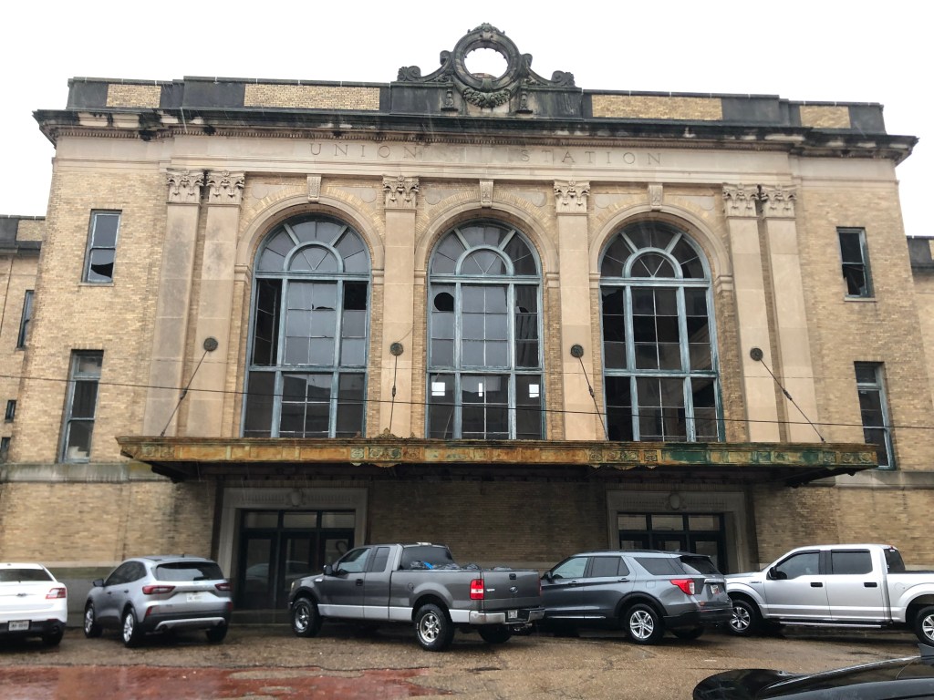
So I parked my car among the many others in front of the building, and I entered through the front doors. What I encountered was a ghostly tomb of a building, which clearly hadn’t been in operation for years.

The once-grand lobby.
The Women’s room.
Forlorn balcony overlooking the railyard.

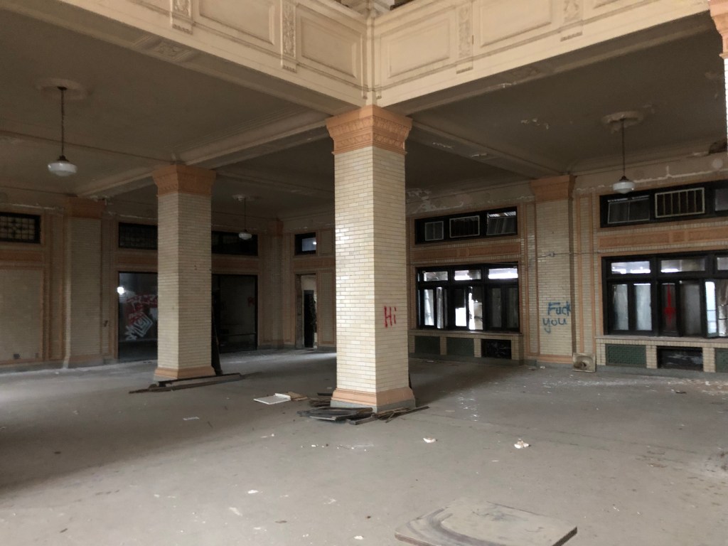
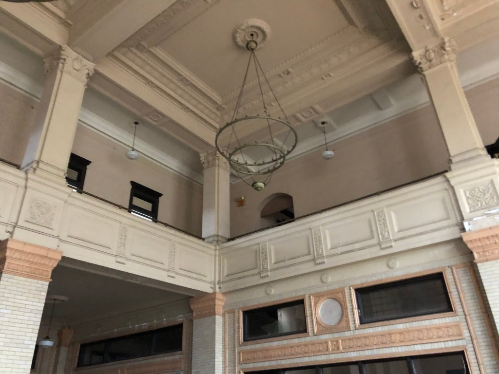
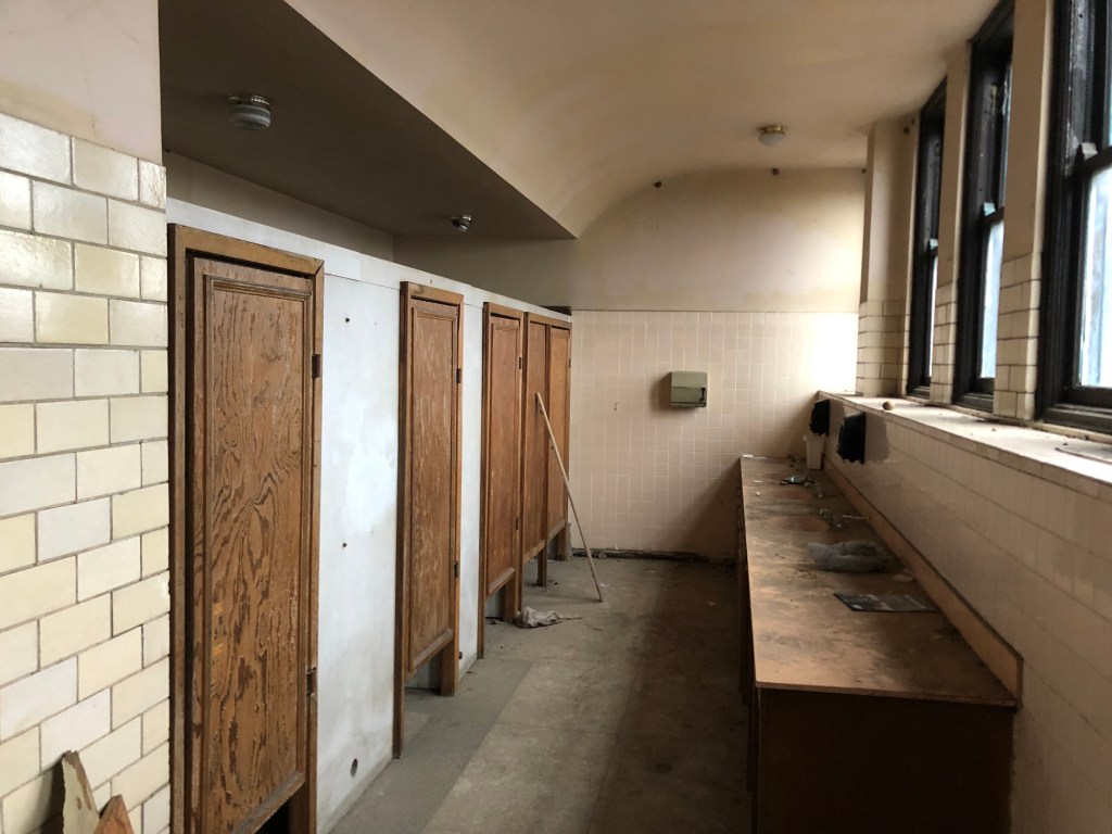
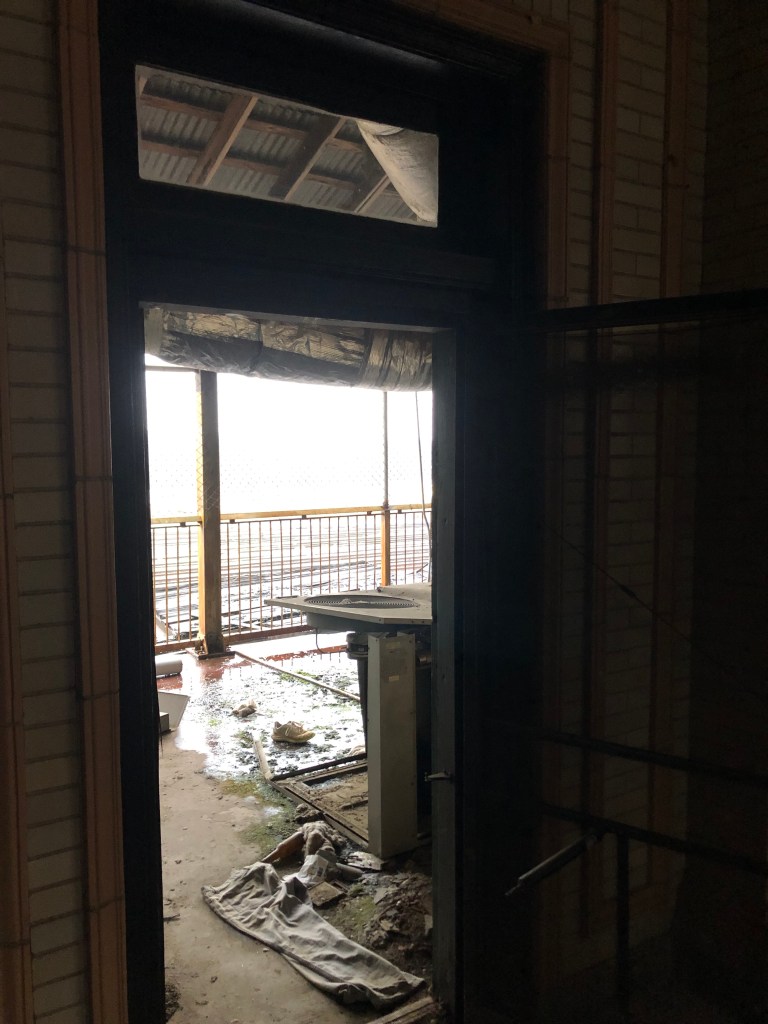
I should emphasize that there wasn’t a living soul in this place. In some places it had been tagged with graffiti, and if other places there was evidence of recent efforts to paint or repair damage. But the whole situation felt odd: why is the front door unlocked? What is this place used for these days?

I went to the back platform, where men in their fedoras and women in their shirt waister dresses would catch their trains.

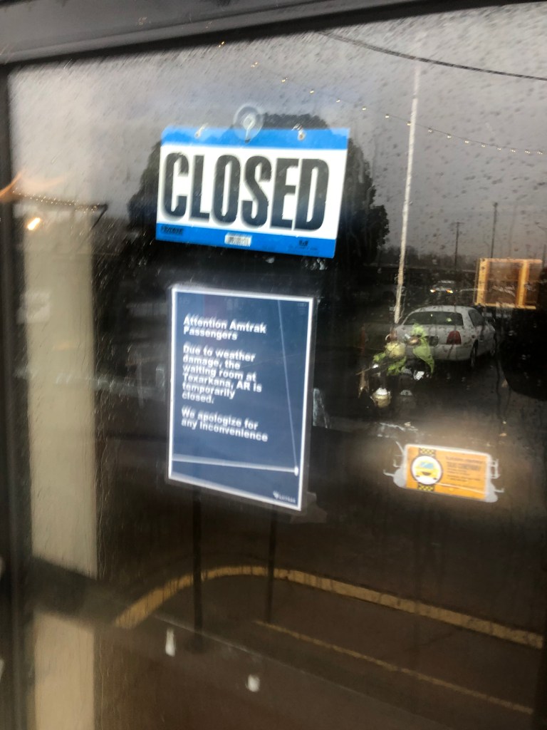
A little more exploring revealed an active Amtrak waiting room and ticket counter! And by “active,” I mean it was closed. But evidently trains still stop at this station. In fact, according to Wikipedia, it is “the second busiest Amtrak station in Arkansas.” I couldn’t tell you how much of an achievement that is, however.

One final, tantalizing piece of information about Union Station: An April 2023 story in the Texarkana Gazette reported that Amtrak and both Texarkanas had signed a good-faith agreement to restore the station, that $200,000 in seed money had been authorized, and that grant funding was actively being sought. I do hope they’re successful; this could make an impressive anchor for the downtown, which clearly has seen better days.

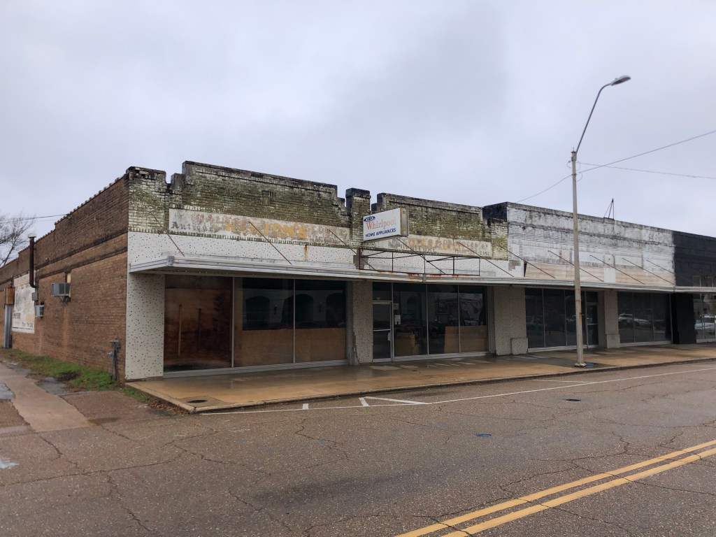
This blog project has repeatedly encountered the question of why do some historic towns survive, others die, and still others wallow somewhere in between. I was thinking about this while I explored Texarkana. There are a number of buildings that have evidently been abandoned, just slowly decaying in place, like this old appliance store.

No wonder the Maytag Man is so lonely.

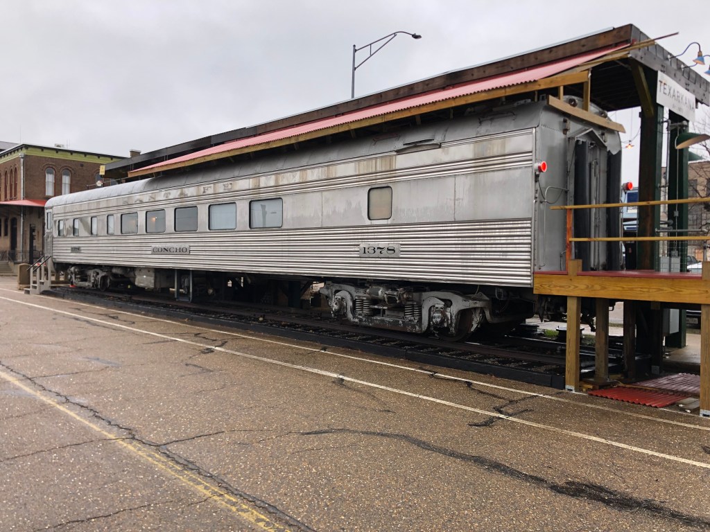
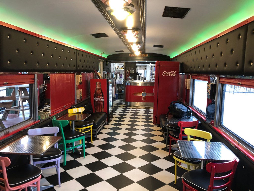
On the other hand, there are a number of public art installations and renovated structures scattered about as well. One of these is a historic streamline passenger car that’s been converted into a coffee bar.

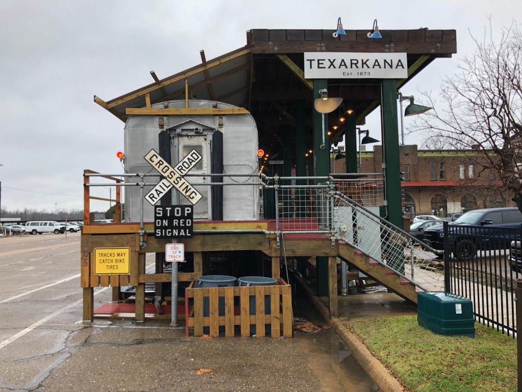
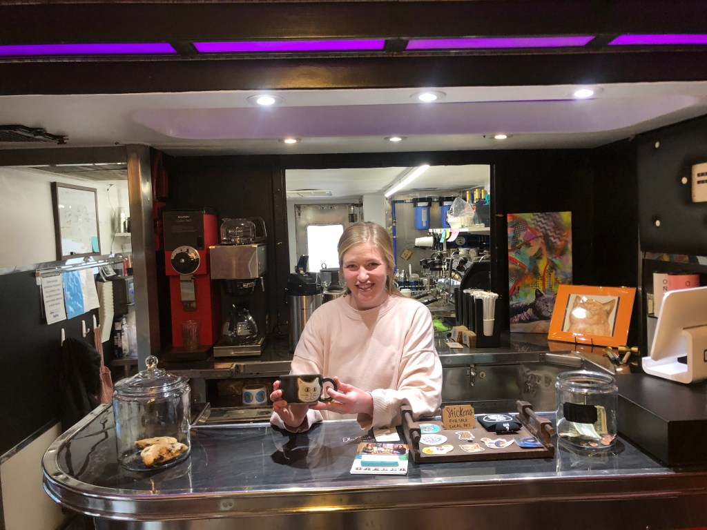
The place is called Alley Cats, and it’s appropriately located not far from Union Station. I went inside and ordered a coffee from Gus.

Gus making my espresso aboard the Concho.

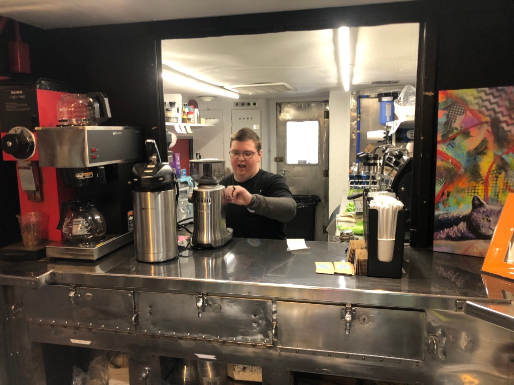
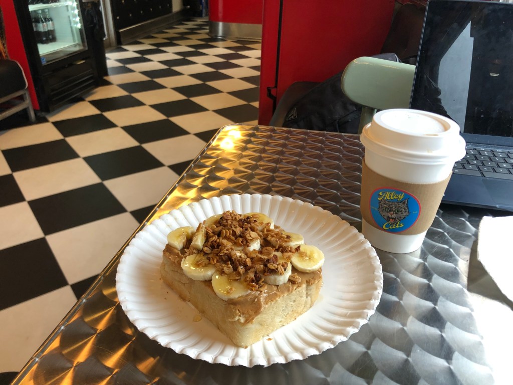
Gus also recommended their Loaded Peanut Butter Toast (thick, locally-made sourdough with peanut butter, honey, granola, and bananas). How could I turn that down??

Breakfast of Champions

Gus explained that the Concho was built in the 1930s, and it used to be a barber car (i.e., a car where train passengers could have their hair cut or perhaps get a permanent) while en route. Many of the original elements of the car, including the extensive use of stainless steel, remain. The car has also been decorated with the work of local artists.

As I tucked into my Peanut Butter Toast, the owner of Alley Cats — one Hillary Cloud — came aboard. She explained to me that she used to be a loyal customer when the business was owned by others. But when those owners had to sell the place last year, she and her business partner snapped it up. She seemed to be motivated by a desire to save a business she appreciated, but also to help advance the revitalization of a downtown that she loves. Hillary is not a major land speculator. She was born and raised in Texarkana, and after going away for college and doing some coaching she returned to her hometown. She spoke passionately, but realistically, about promoting local business. Alley Cats sources some of its food (including that delicious sourdough) from local businesses, and showcases the work of local artists. It was clear to me that people like Hillary make the difference between towns that thrive and those that decline.

Owner Hillary Cloud, with a mug produced by a local artist.

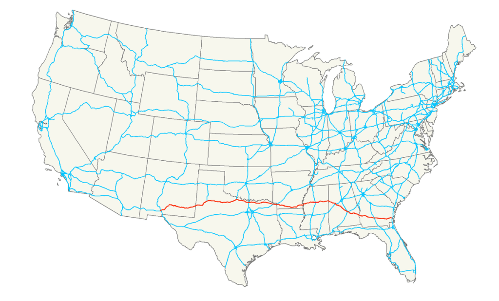
Finally, well-fortified with peanut butter, it was time for me to get onto Route 82–which was the whole point of this trip.

US Route 82 is like most of the other US highways that I’ve documented on this blog: most of it has one or two lanes in each direction, and it becomes the main thoroughfare of the towns it connects. These routes are not heavily traveled, as most of them were superseded by interstates the middle of the last century. As a result, they often feel like The Land That Time Forgot.

For this first day on the road, my goal was to drive from Texarkana to Greenville, which sits just beyond Arkansas’s border with Mississippi. Along this route there are only a few towns of any notable size. Much of the drive is flat or gently-rolling hills cutting through stands of second- or third-growth hickory.

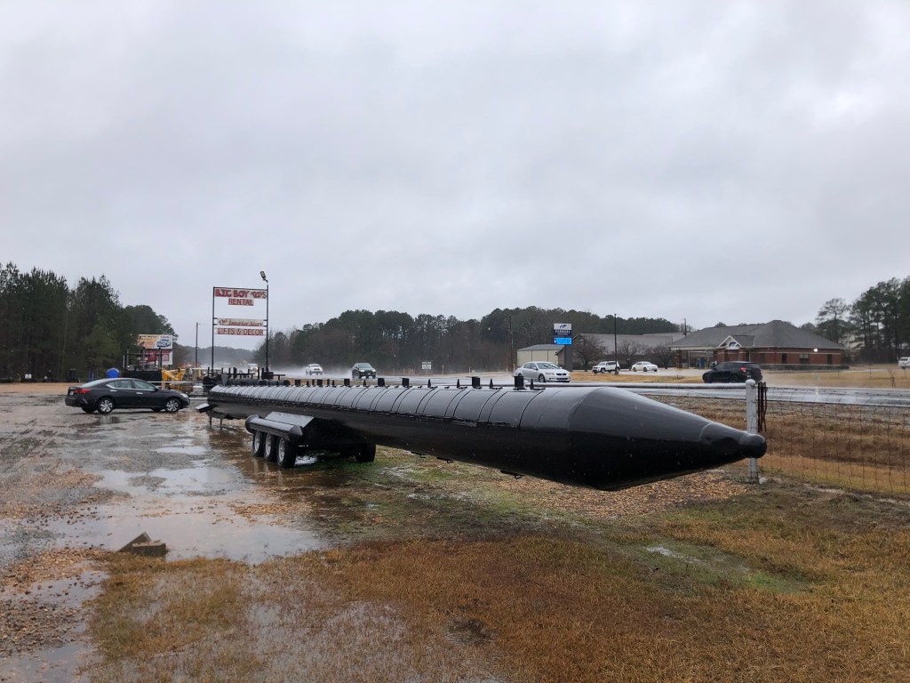
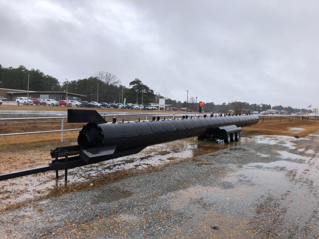
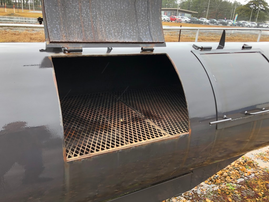
One of the first towns I came to after Texarkana was Magnolia, Arkansas (pop: 11,000). Everyone wants to be known for something, and Magnolia is known for its World Championship Steak Cookoff each spring. They like to promote their “World’s Largest Charcoal Grill,” which I saw parked alongside Route 82. It is an impressive piece of ironwork which resembles an ICBM.

View from the back. (I probably should have taken a panorama shot!)

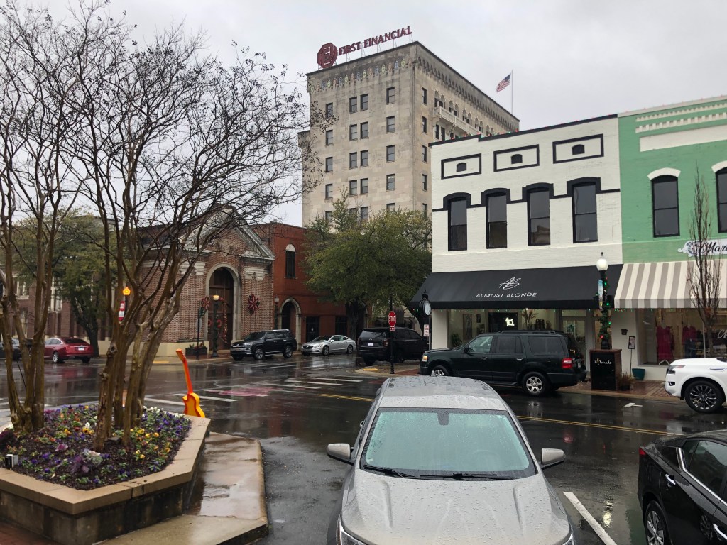
The next town was El Dorado (pop: 17,500). Established around the same time as Texarkana, it’s downtown appears to be thriving. Attractive public spaces, prosperous businesses, and public art displays abound.

And then I came to Crossett (pop: 4,700). Crossett isn’t a big town, but it’s noted for something that’s come to be known as the Crossett Spook Lights. Rather than try to describe them myself, allow me to quote from something called The Encyclopedia of Arkansas:

Outside of Crossett, where the old railroad tracks once lay, an unexplained light has become a local legend. It has reportedly been seen consistently since the early 1900s by multitudes of people. The light is typically seen floating two to three feet above the ground but also is said to move into the treetops and sometimes side to side. The light reportedly disappears as one walks toward it and then reappears the same distance away, so that one can never get a close look at it. The Crossett Light’s color reportedly ranges from yellow or orange to blue or green.

It’s claimed that the lights are connected with a long-ago incident involving a railroad worker who was decapitated. I did a lot of research on this as I had a snack at a Crossett fast food joint, and it seems that there are many people who earnestly insist they’ve seen the Spook Lights. However, there was a lot of disagreement as to where, exactly, they were to be found, and under what conditions. Undaunted, I waited into the approach of nightfall and I headed out a lonely dirt road into the middle of a dark forest to see what I could see.

I do believe in spooks, I do, I do….

It was getting cold and dark, and the rain was unrelenting. But I dutifully parked in the middle of the narrow road (I encountered no other cars) and waited for the lights. I confess it was eerie out there, and more than one I was startled by a bird or a wind-blown tree branch. A few times I thought I saw a small light briefly winking at me through the windshield, but as it was raining, I chalked that up to the drops of water.

Finally I gave up and slowly headed back along the muddy road. Then, what should I see, but several small yet distinct red and green lights!

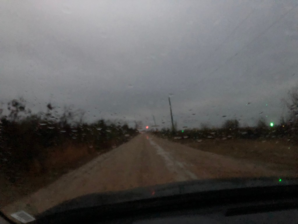
I was beside myself! The stories were true! I can’t wait to report back to my loyal readership! Assuming, of course, I’m not about to be abducted by aliens…

I continued forward toward the lights and…alas, I discovered their cause. There’s a small, private airfield, complete with guidance lights, a few hundred yards off to the side of the road. Talk about a buzzkill.

I got back onto Route 82 and after an hour I crossed the mighty Mississippi and entered Greenville. This is where I’m spending the night.

BEER OF THE DAY

In Greenville I went to a local pub called “Spectators,” where I asked for a local brew. I was presented with a Southern Pecan nut brown ale, brewed by the Lazy Magnolia Brewing Company in Kiln, Mississippi. The beer is brewed with roasted pecans, and has an ABV at a very modest 4.5 percent.

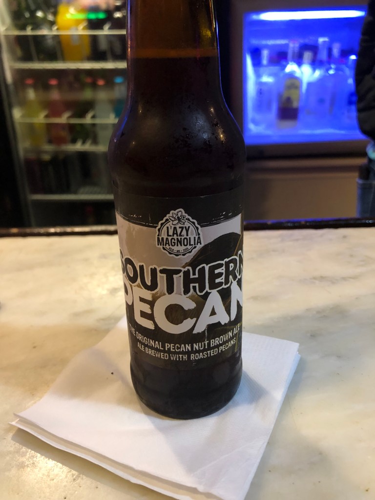
Despite the brown ale style and the addition of pecans, this beer is pretty light. It has no bite to speak of (hops seem almost to be absent). But neither is is malty sweet. Still, it’s as smooth as silk, going down very easy indeed. I would have liked to have seen it in a glass (it was served in a bottle), for its dark color and head. (I was able to see some foam in the bottle.) Anyway, it’s an inoffensive beer, but not memorable. I give it 2.5 starts out of five.

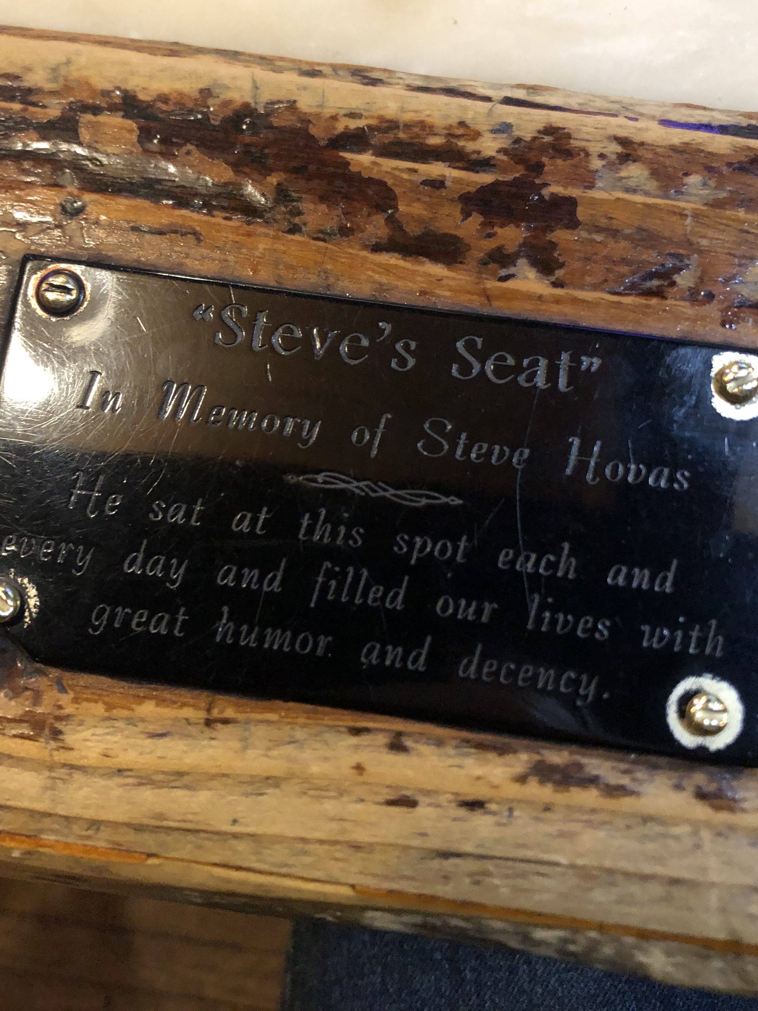
Oh, as I was leaving, I noticed a plaque on the edge of the counter where I was sitting. I guess it was meant to be!

Road trips

The Winter of 82

T.S. Eliot called April “the cruelest month,” but I’ve always felt that January is more deserving of that title. This is of course largely due to the obvious and excruciating bathos occasioned by sudden termination of a string of merry holidays–all the decorations, costumes, huge meals, family reunions, parties, and music come to a screeching halt after a superfluous sip of champagne and a perfunctory kiss from our sweetheart literally at the first moment of January.

 I think we are in rats’ alley/Where the dead men lost their bones.

But there are other reasons I nominate January as the cruelest month. January is cold and dreary; the skies are gray and the trees are bare and the front lawn is brown. The rain curtails outdoor activities, and even if you do get a clear day, the sun seems to set just a few hours after it rises. Add to this the arrival of W-2’s and other tax forms that signal the unwelcome beginning of tax season. And if that’s not enough, January is the month with the most American deaths. According to the CDC, about a quarter of a million of us die each January. Cruel indeed!

Faced with 31 days of this wintry and literally life-threatening cruelty, I decided it was time for a road trip. A change of scene might do me good. And even if I can’t escape the month, perhaps I can escape the worst of the weather. So I consulted my trusty Atlas and searched for a suitable route in the South. And I came up with US Highway 82.

Highway 82 was established in 1931, initially as an east-west route between Mississippi and Arkansas. It was extended over the years, and today it runs from Alamogordo, NM all the way to Brunswick, GA on the east coast.

Route 82: The Official Highway of the Cruelest Month.

I’m not going to be driving the whole route, however. I’ve already crossed the Texas panhandle more times than I’d like to remember. Therefore, I’m going to begin my journey at the Texas-Arkansas border, in the imaginatively-named town of Texarkana.

The town that takes the concept of drive-through dining to a new level.

The drive from Texarkana to Brunswick is about 900 miles, and I plan to get there on Tuesday evening. Then, on Wednesday I’m going to make a special side trip before heading home. I won’t reveal the surprise, but suffice it to say that it will be a monumental achievement in the Boilard Travel Archives.

Right now I’m at Sacramento Intergalactic Airport, waiting on a red-eye flight that departs at 11:59 pm. I’ll be in Texarkana tomorrow morning, so expect my first blog post from the road tomorrow night.

Until then.

bridges · California history · trains

Before the Bridge

Eons ago, when I finished college, I moved to Sacramento, and in the succeeding years I made many weekend trips back to the familial homestead in Sunnyvale. The trip required crossing the Carquinez strait on the Benicia-Martinez Bridge. In those days, the bridge had traffic going in both directions, but in 2007 a second bridge was opened and each of the two bridges was henceforth devoted to traffic in a single direction.

My overland trail.

As I crossed the Carquinez Strait in my Studebaker Hawk (which I’m not making up), I would always glance at the old railroad bridge that ran alongside me. Often I’d see a train rumbling over the creaky structure. Here’s a shot I took this morning of the railroad bridge flanked by the two automobile bridges:

Looking south, from Benicia to Martinez.
Aerial view, stolen from the Internet.

The Benicia-Martinez Bridge railroad bridge opened in 1930. It was–and still is today–the second-longest railroad bridge in North America. But did you know that trains had already begun crossing the Carquinez strait more than half a century earlier? How could this be?

To answer this question, I visited the unassuming town of Benicia (pop: 27,000). Briefly California’s capital (from February 1853 to February 1854), Benicia today is famously home to my son Ian and daughter-in-law Katelyn. But it’s also home to this old depot which can shed some light on our railroad bridge puzzle:

End of the line, in a way…

This 144-year-old depot was originally built in 1879 in the small town of Banta, California (pop: unclear, though probably around 100 according to this account). Banta was a whistlestop on the original transcontinental railroad. Westbound trains would make the final leg from Sacramento to the Bay Area by way of the Altamont Pass, which they would cross just after passing Banta.

The original route.

But the same year the Banta train depot was constructed, the Southern Pacific opened a new, shorter route from Sacramento to the Bay Area. This route crossed the Carquinez Strait, shaving off several hours from the old route over Altamont Pass. But since the Benicia-Martinez railroad bridge wouldn’t be constructed until 1930, trains were ferried over the Strait. Seriously. An enormous ferry dubbed The Solano was constructed for this purpose. Westbound trains would slowly chug over the Benicia Pier, roll onto the Solano, and make the half-hour trip to Port Costa, about a mile across the water. From there the trains would return to the mainline and continue to the end of the line in Oakland.

The new route.

This morning I stood on Benicia’s modern fishing pier and looked out at the ancient pilings from the old pier where the Solano used to dock.

The Solano’s old haunt…perhaps literally?

The Solano, which remained in continuous operation for 51 years, had a length of 425 feet and was equipped with four sets of tracks. It was the largest railroad ferry in the world.

Demand on the line increased continually, and eventually it was decided that a full-size railroad station was needed on the Benicia side of the ferry crossing. So in 1902, Southern Pacific uprooted that station they’d built in Banta, floated it on a barge to Benicia, and planted it where you see it today.

The Solano kept working around the clock, year in and year out. In 1914 she was joined by a sister ferry, the Contra Costa, to absorb the growing demand on the line. But then in 1930, the railroad bridge (which we encountered near the beginning of this post) opened, and the ferries instantly became obsolete. They made their last run in November 1930.

The final run, loaded with well-wishers.

So after exploring the depot and remains of the Benicia ferry pier, I enlisted son Ian to drive us to the other end of the ferry crossing, which was in Port Costa (pop: 200). Port Costa is a small, funky, historic town, replete with a Doggie Diner head. (People of a certain age may remember getting a hotdog at one of the Doggie Diner restaurants in the Bay Area in the 1960s or 1970s. I sure do! Those who don’t remember them can get enlightened here.)

Ian and a midcentury Bay Area icon.

After a bit of walking around Port Costa we came upon the remains of the southern dock of the Carquinez ferry crossing:

The Solano’s southern haunt. Benicia is directly across the strait.

So, for those of you keeping score at home, we’ve managed to find the depot from which ferry-bound trains departed, the remains of both ferry piers, and the bridge that put the ferry out of business. But what of the ferry itself?

A little Internet research revealed that the Solano was decommissioned and towed out to Antioch in 1931. There she was scuttled near the bank of the San Joaquin River and partially submerged to serve as a breakwater. She remained there, largely identifiable in her old form, for about half a century. But in the 1980s some clown was setting off fireworks and accidentally set The Solano ablaze, and she burned to the waterline.

Naturally, Ian and I headed over to Antioch to see what remained of the Solano. The answer is “not a lot,” but there’s still a ghostly presence. Check it out:

Remains of the Solano in Antioch. We’re looking at the port side of the ferry, with metal rods from the bow poking out of the water on the left.
The 40-foot-high A-frame that housed one of The Antioch’s two paddlewheel engines still rises from the wreckage.
Aerial view, courtesy of Virtual Globetrotting, clearly shows the outlines of The Solano.

So that’s pretty much it. As always I’m struck by how physical barriers were overcome in the Age of Steam…and how remnants of that era can still be seen all around us, if we’re just willing to look.

cemeteries · churches · Ghost stories · Halloween · Road trips

Bonus! A True Halloween Story

I hope you all enjoyed this month’s Halloween offering, “A Dying Wish.” Of course, the way the timing worked out, the story ended on October 30 (All Hallow’s Eve Eve). So for today, which is Halloween proper, I offer this “true” ghost story for Halloween.

[Editor’s Note: Long-time readers may recall that I related this incident some years back, while I was on my US Route 60 trip. But that story appeared in the days when I was composing my so-called “blog” in Google Docs and emailing it to a small number of friends, so you might not have seen it. We pick up the story on Day 7 of my trip, as I’d entered West Virginia.]

It struck me today that this drive across the country on US 60 is similar in many ways to my trip across the country last fall on US 50. Sure, US 50 is a northern route, and US 60 is a southern route, so they each have a distinct flavor. But there are many similarities between the roads. Both are mainly two-lane highways, and both cut through the middle of countless towns. The two roads even end up in the same state, not too far apart. And this morning I was feeling that this leg, through West Virginia, feels as remote and lonely as US 50 passing through Nevada. They call that stretch of US 50 “The loneliest road in America,” and for good reason. In a similar way, today’s stretch of US 60 had me driving for long stretches without seeing a town or even another car. It’s not a bad thing. In fact, it’s pretty therapeutic to be driving all alone along a windy road closed in on both sides with foliage. It’s calming and gives you time and room to meditate.

The narrow ribbon of asphalt that is US 60, cutting through the briars and brambles of The Mountain State.

As the afternoon wore on, the sky began to cloud over and the mountains began to take on a more melancholy feel. I was passing through the unincorporated village of Sam Black Church (named after a church building, which itself was named after an itinerant 19th-century minister). Here’s the church:

A white church named Black.

As I was passing through the deserted village and sensing the melancholy air, I came across this sign:

Roadside ghost story.

This was awesome! A “real” ghost story! (The full tale is explained here, in Wikipedia.)

Maybe it was just how my mood was affected by the weather and the long, solitary drive, but I felt compelled to find the grave of this Zona Heaster Shue. Surely she would be buried close by. After a quick consultation of Find-a-Grave on my iPhone, I found that she was buried in a churchyard just a few miles away. I set out for Soule Chapel Methodist Cemetery. The route was a narrow, twisting road over some hills, without a living soul anywhere in sight. Not so much as a grazing horse was out in the fields.

A good road for ghostspotting.

Finally, I arrived at the cemetery, which turned out to be a 150-year-old churchyard next to a white clapboard chapel. It was the perfect setting for a ghost sighting.

“So sure of death the marbles rhyme, yet can’t help marking all the time/How no one dead will seem to come. What is it men are shrinking from?” -Robert Frost

I walked among the graves and quickly found Zona’s headstone:

I have to admit that, while it was gratifying to have found the “ghost’s” grave, I was disappointed that the headstone looked so much fancier, perhaps newer, than the others in the cemetery. And it’s a little garish to identify her as the Greenbrier Ghost on her headstone. (The ghostly phantom you see in the headstone is my reflection, which just goes to show how shiny the headstone is.)

I should point out that this is Zona’s second headstone. She was first buried shortly after her death, but after her ghost supposedly appeared to her grieving mother, the authorities were compelled to exhume her body. Her corpse showed evidence (earlier overlooked) that she’d been murdered, and her husband was implicated and soon sent to prison. When she was re-buried, someone saw fit to identify her as the “Greenbrier Ghost” on her headstone. I assume that she’s OK with that, because even in death she doesn’t seem to be shy about communicating her complaints to others.

OK–It’s me again, on Halloween 2023. I hope you enjoyed all this month’s spooky offerings. Feel free to suggest your ideas for next October! Meanwhile, watch this space for another road trip soon.

sdb

"A Dying WIsh" · Ghost stories · Halloween

ADW Part 13

It was many months before the whispered asseverations about my reception finally attenuated. Many of the guests never spoke a word about it afterwards, but a few undertook the manner of Coleridge’s Ancient Mariner, seeking out listeners for his “ghastly tale.” Their words, for the most part, were dismissed as the products of overly imaginative minds, jealousy, and alcohol.

Harder to dismiss was the disappearance of Dr. Triste. The police spent weeks scouring the city and surrounding countryside for clues, but their efforts were in vain. He simply vanished, having been last seen at my ill-fated gathering. Some claimed there must be a connection between the disappearance of Dr. Triste and the alleged resurrection of Prof. Glauben, but these theories were largely considered too fantastic to be believed. Ultimately, my genuine innocence (at least as regards Dr. Triste) was accepted by the authorities. Given that neither Dr. Triste’s nor Prof. Glauben’s corpus was ever habeas, the case was dropped.

Over time I tried to forget those incredible events that followed from disinterring Prof. Glauben’s skeleton. My valet Jacob was immensely relieved that I ended my strange and secretive ways. And I began courting the young Diera Marshall, who, like her father, spoke not a word about the shocking events at my home that evening.

I cannot recall the precise evening, but approximately a year after the disappearance of Dr. Triste I awoke from a fitful sleep with a strong urge to take a walk in the night air. It was as though I was being beckoned. I had no choice.

I dressed hurriedly, throwing on heavy clothes to protect myself from the chill. I glanced at my watch; it was 1:15 am.

By the time I had left the warmth of my home I realized where I was headed. Of course! Why hadn’t I thought of it earlier?

The cold winter wind gnawed at my face, but I walked steadily towards my destination, crushing dead leaves beneath my feet. Fog was all that lay before my lantern’s light, but I knew the way by instinct, even though I had only been there once before. After a full two hours I saw the imposing stone edifice before me. I made my way to the small hill behind the prison, and pushed my way through the creaky wrought-iron gates I’d entered two years earlier. It took only a few minutes searching to find the headstone which bore Prof. Glauben’s name. 

For some time I stood in the dark silence, staring at the grave and mulling over those past outré events. They were already becoming a fuzzy memory, though it still pained me greatly to recall the expression on my mentor’s bony face when he left our reception. Yes, he had to be here; again, it all fell into place. I struck the moist earth with my spade.

An hour later I had for the second time opened the grave of my friend and teacher. For the second time I removed the coffin lid. And for the second time my heart sank. There, amid the rotting remains of a black tuxedo, lay the skeleton of Dr. Glauben, silently weeping. 

“Nein, Venwick, let me stay here, beneath ze earth, where I belong,” he pleaded.

“I shall do as you request,” I replied with trembling lips, “but please allow me to say goodbye.” The skeleton looked up from his coffin. “Professor,” I continued, “Did you talk with Dr. Triste after you left the reception?” Prof. Glauben said nothing. “I believe you followed Dr. Triste from the party because you knew something about him–or rather you deduced it–and when you confronted him outside he admitted that he, too, had achieved immortality.”

The skeleton winced, and I went on. “Yes, Professor, you two were –you are–in the same predicament, and after hearing your statements of that night I conclude that you both decided to act as dead men, even if you can’t die.”

Prof. Glauben remained silent for a moment, then opened his jaw with a bony click. “Ja. Ve have forfeited ze hereafter,” he said softly, “and now ve must suffer. But ve shall not continue to live our lives among humans. Ve decided zhat ve must behave as ze dead.” A tear emerged from an eye socket and rolled down the side of the skull. “Und now, Venwick, you must leave. Please to close ze door after you.”

With a heavy heart I replaced the coffin lid and shoveled earth back into the hole. Then after crossing myself I turned to walk home. Breaking over the red horizon ahead of me was the morning sun, harbinger of a new day, bringing with it the blessing of life and the promise of death….

Or vice versa.

THUS CONCLUDES OUR TALE. WATCH FOR A SPECIAL HALLOWEEN BONUS TOMORROW!