California history · Cars · Road trips · trains · Uncategorized

From Oil to Oat Milk

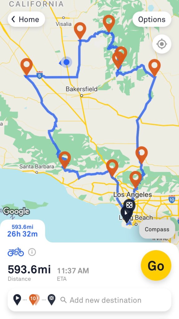
Today’s travels focused primarily on CA Route 33. To get there I took an easy and leisurely route across the Central Valley floor to Blackwell’s Corner at the intersection of CA Routes 46 and 33. Blackwell’s corner is one of my favorite stops on California roadtrips, as it’s a friendly and well-provisioned oasis in the middle of nowhere. A single building is outfitted with a gas station, a diner, a grocery store, showers, bathrooms, an ice cream fountain, a homemade fudge kitchen, and a James Dean shrine. For it’s at this spot that James Dean was last seen alive before his fatal car crash a half-hour later on September 30, 1955. He was 24 years old.

Well, he did star in Giant, you know.

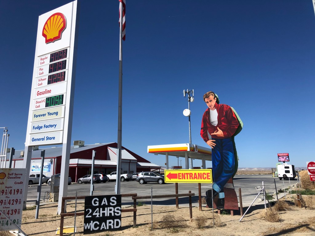
Blackwell’s Corner traces its lineage back exactly 100 years — to 1921 — when George Blackwell opened a rest stop on the site. I’ve stopped here many times. Sure, the gas is about a buck a gallon more expensive than elsewhere, and the snacks are severely overpriced. And the fudge doesn’t do much for me. But this place is an institution, it feels really earnest, and there’s really no other options for rest and refreshment in the region. It’s reassuring to know that it’s here. So I’m happy to support it.

Some years back Blackwell’s put in this 1950’s-themed diner to capitalize on its James Dean connection. Even before Covid, I’ve never seen anyone eating there.

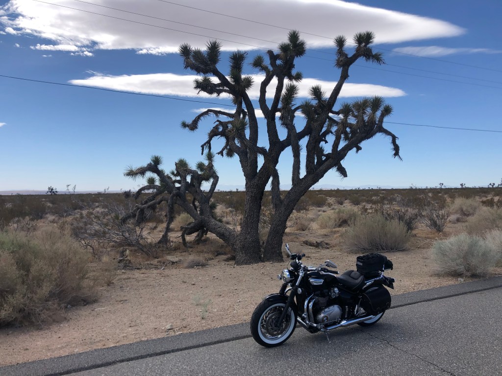
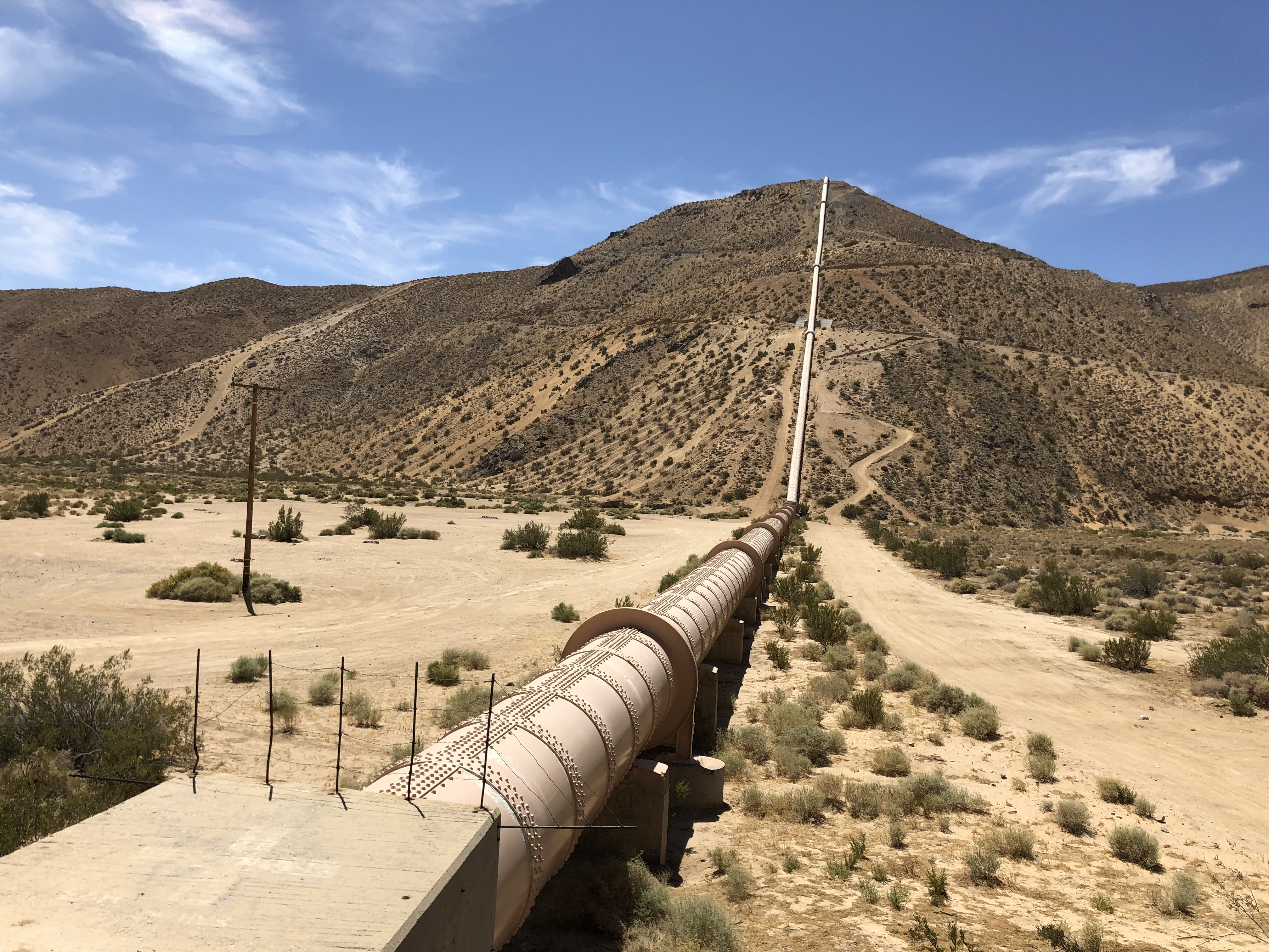
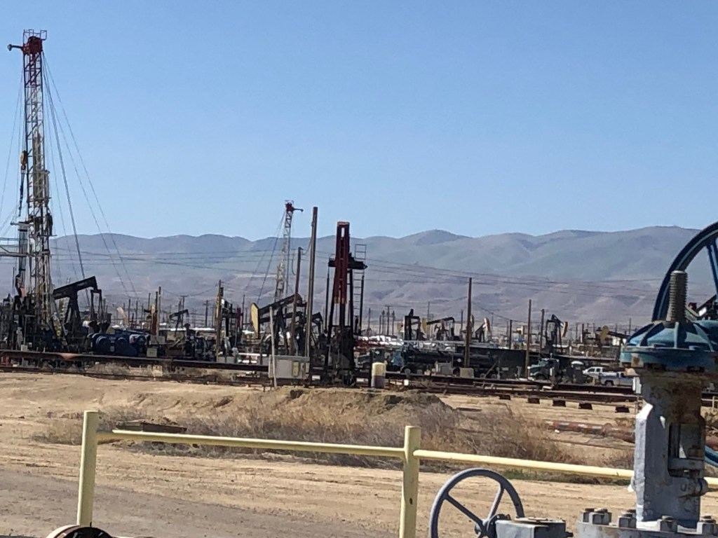
So after gassing up and getting a bottle of juice for breakfast, I turned onto CA Route 33. Like Blackwell’s Corner, Route 33 reminds me of a reliable old friend. I’ve traveled segments of 33 on various occasions — particularly the stretch known as the Petroleum Highway. This segment is a hellscape of oil rigs and pipelines scattered willy-nilly across the parched and poisoned earth. It’s like something out of Mad Max, and somehow you can’t take your eyes off it.

“I’m just here for the gasoline.” — Mad Max

One of the notable intersections in the area is where Route 33 is crossed by “Brown Mat. Road.”

Wipe your feet.

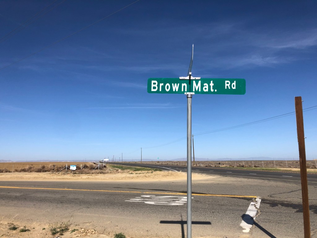
At first I thought this meant the road was covered with brown mats, or appeared to be so covered. Then I noticed that “Mat.” is short for “Material.” So why would you name a road “Brown Material Road”? Is it simply an odd reference to a dirt road? Or a euphemism for something scatological?

Could you please be more specific?

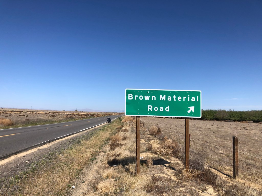
After doing some research, I discovered that the name references a business that used to be on the road: A place called Brown’s Material Supply Company. So it’s really analogous to Magic Mountain Parkway in Santa Clarita.

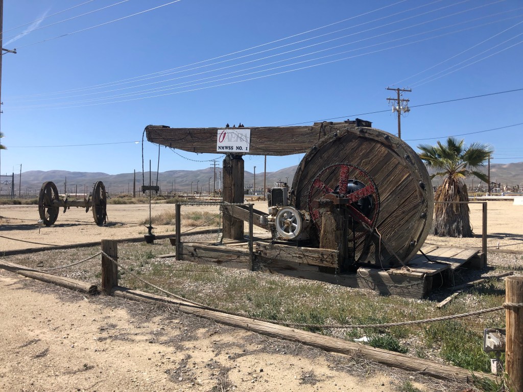
Anyway, the Petroleum Highway is much more famous for its oil than for Brown Material. The scale of production is impressive. This region (Kern County) produces fully three- quarters of the state’s oil (and about a tenth of the country’s overall oil production). One of the major oil producers, Aera, takes great pride in showing off one of its old pumps, tarted up with Christmas lights next to the road.

Long since retired.

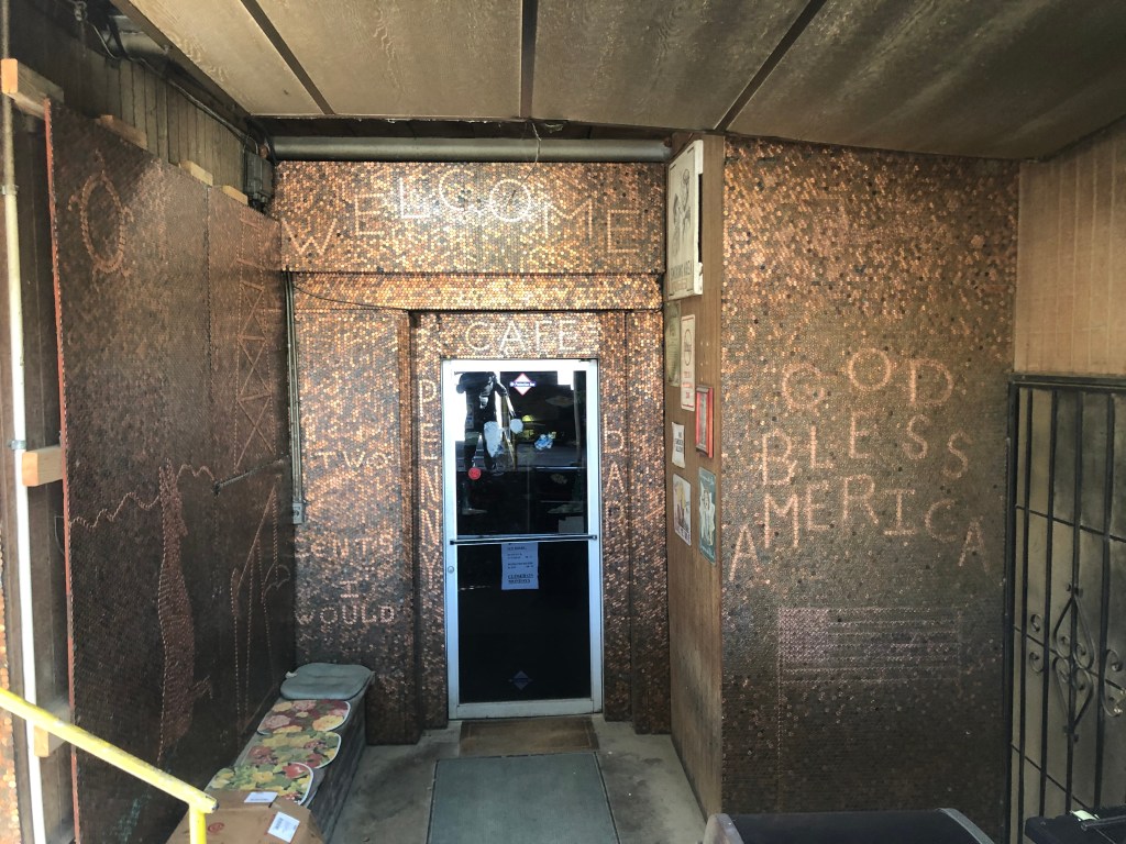
In the midst of these oilfields, I happened upon the Oakwood Bar-B-Q and Bar in the tiny town of McKittrick (pop: 115). Under the main yellow sign was a tarnished copper sign on the outer wall that read “Penny Bar.” Upon closer inspection, that entire sign was made of pennies.

I’m definitely not getting my BOTD here!

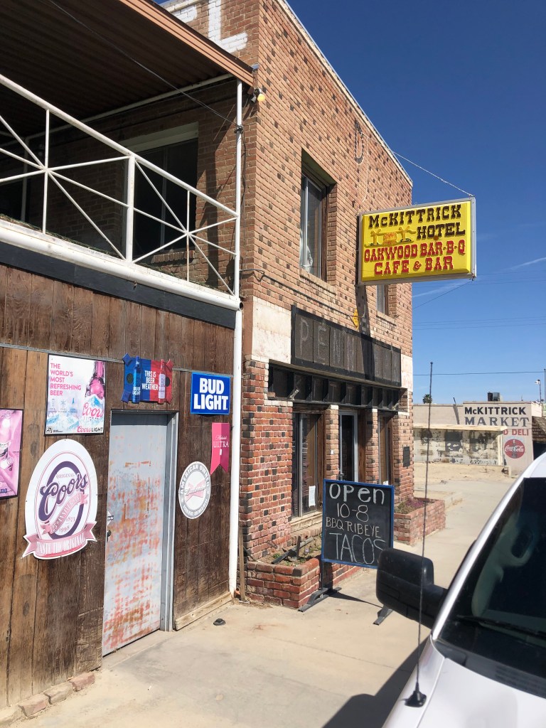
This seemed intriguing. A plaque informed me that the building’s owners have over time glued over a million pennies to the bar, walls, and other flat surfaces of the building. I didn’t take any photos inside the building, since the roughnecks (or whatever the oil workers call themselves these days) that populated the establishment didn’t look like they’d take too kindly to a stranger photographing them. But I did get this photo of the back entrance:

Penny for your thoughts?

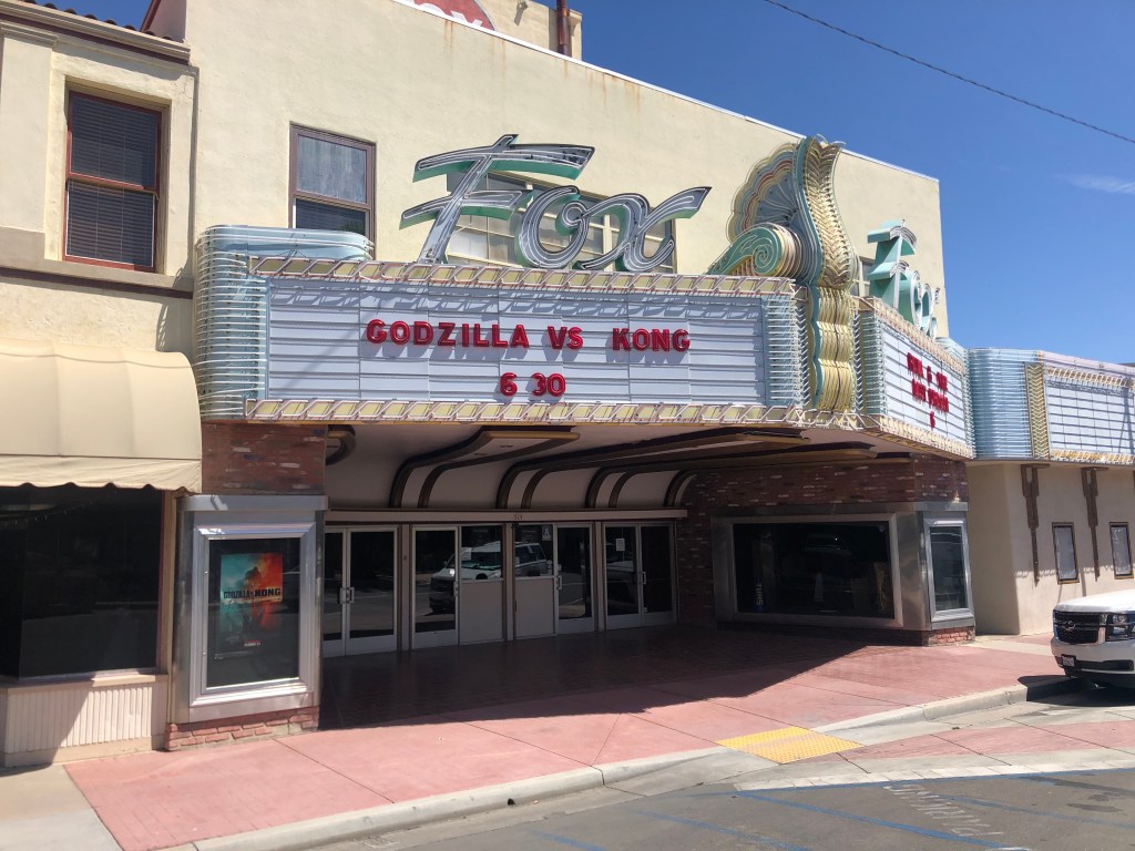
A little further along Route 33 I came to the town of Taft (pop: 9,300). Taft is just about the most southern town of the San Joaquin Valley, nestled against the foothills of the Transverse Ranges. Taft was originally named “Moron” around 1900, but after it burned down in 1909 it was renamed after William Howard Taft, who became president that same year. Taft is one of the more substantial towns on Route 33, and has close ties to the oil industry. While its downtown still feels stuck in the mid-20th century, it still feels viable and maybe even prosperous. The Fox Theater dates back to 1918. It’s had ownership changes and was even closed for awhile, but on this trip it seemed to be fully restored and functioning. Indeed, it’s showing “Godzilla vs. Kong” tonight!

Would have been great if Mothra could have been part of the showdown.

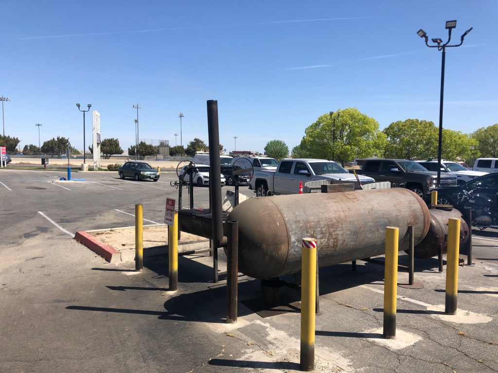
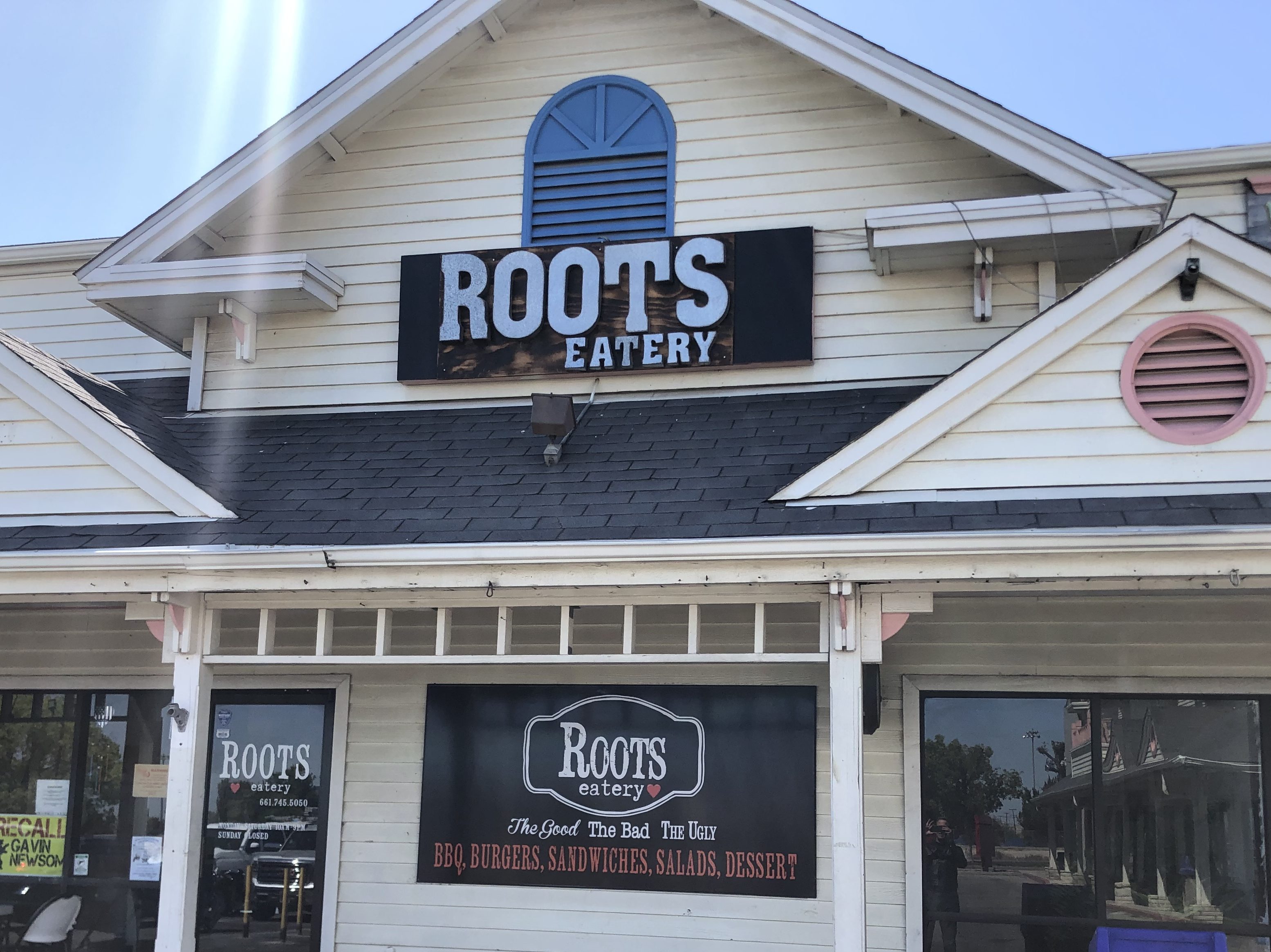
It was now getting to be lunch time. Because there would be no towns of any substance for the next 75 miles or so, I decided to get lunch at a place called Roots Eatery. Even though it was plopped down in a strip mall, two elements spoke of promise: (1) the meat smoker puffing away in the parking lot, and (2) the promise of “Good, Bad, and Ugly” on the menu.

Roots’ smoker. Somehow I doubt that the county health department has inspected, let alone approved, the setup…
I wish they’d point out the “bad” part of the menu.

I had a toothsome smoked pastrami sandwich with smoked bacon and smoked gouda on grilled and buttered sourdough. It was just what the doctor ordered, even though my arteries didn’t approve.

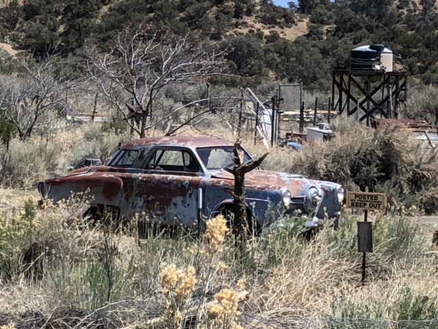
On the outskirts of town I encountered two notable things. One was this car; Points will be awarded to the first person to identify the make and year.

Second was this homemade art installation. Alert readers will recall that I have a soft spot for folk art. This trip has been largely devoid of any such sightings…until now.

Shades of Almira Gulch…

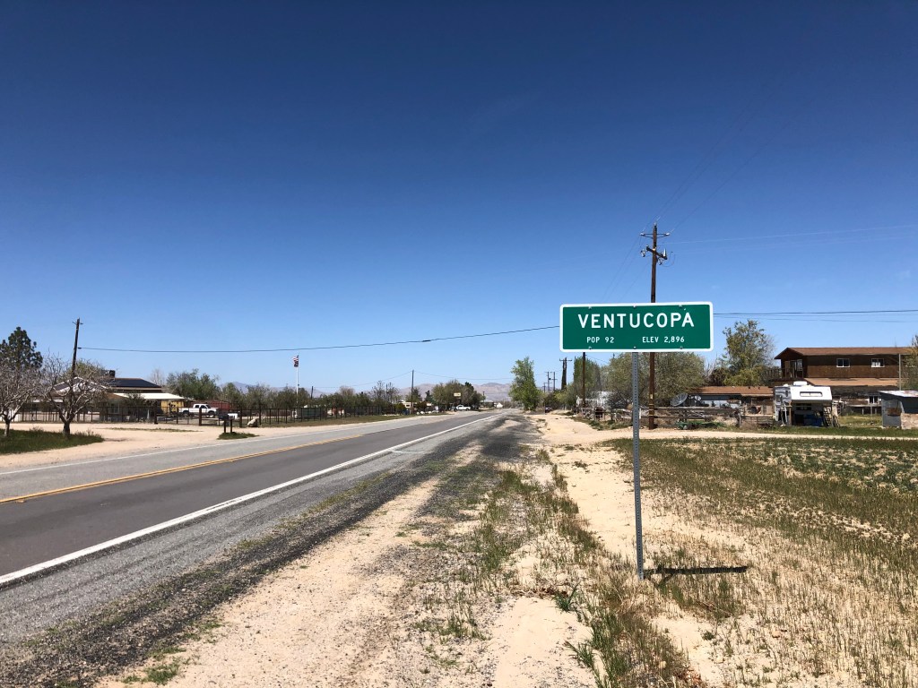
It was now time to leave the valley are start climbing up over the Transverse Ranges. The last bit of Kern County is commemorated by the town of Ventucopa (pop: 92), which marks the transition from Kern’s Maricopa to the county of Ventura.

As if “Inyokern” weren’t bad enough…

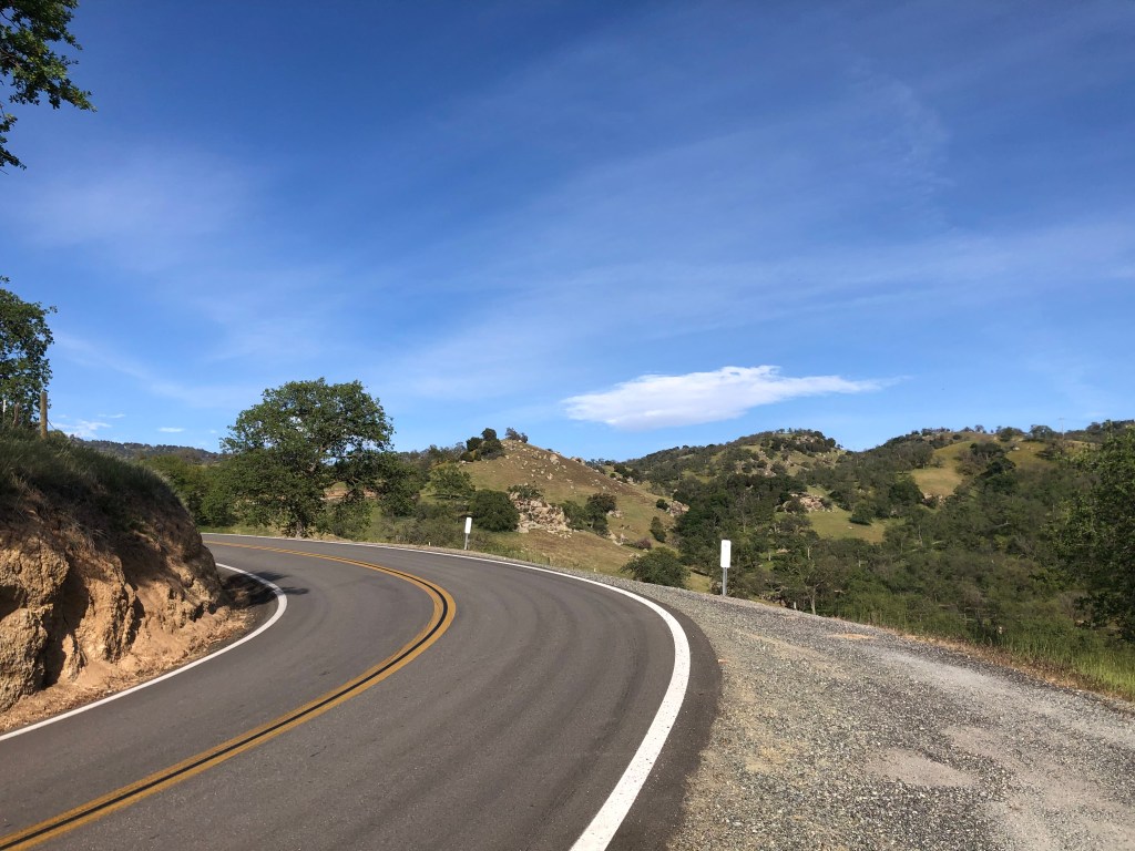
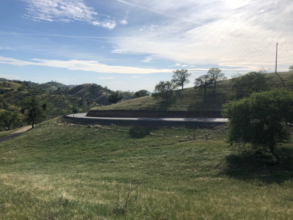
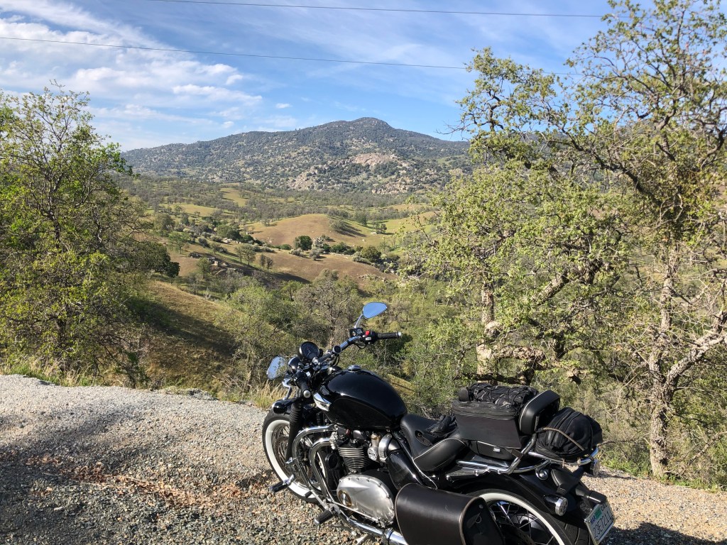
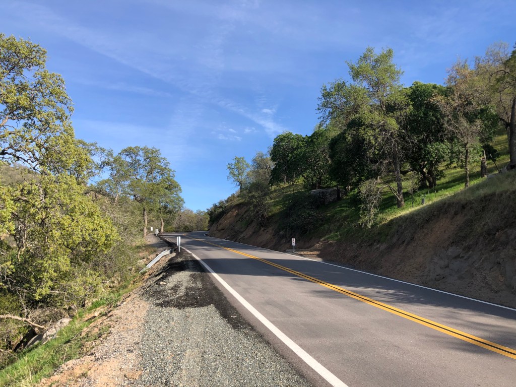
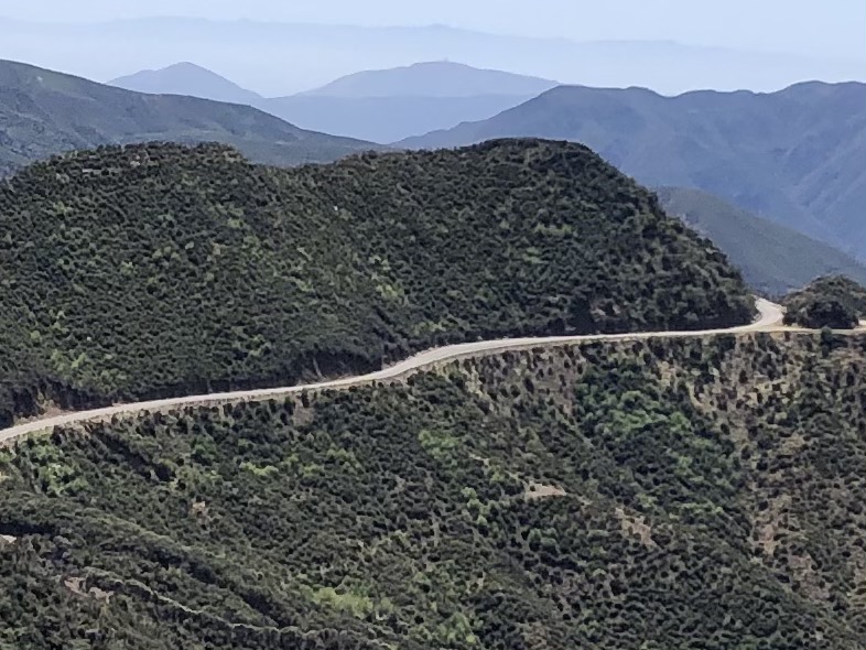
I was entering my favorite part of Route 33: the climb over the Transverse Ranges and the Santa Ynez Mountains. It’s a meandering, little-traveled, two-lane road with grasslands, oaks, and commanding views. Plenty of switchbacks allowed me to take panoramic photos of the road I was travelling.

The red line marks Route 33 over the Transverse Ranges
Still chugging along…
On the way to Ojai

Finally I was delivered into the town of Ojai (pop: 7,500). If you’re wondering what happened to all the country’s hippies, I can report they’re alive and well and living in Ojai. Seriously. I’ve never seen so many healing crystals, incense shops, natural food coops, organic this and free-trade that. Ojai has a city ordinance banning chain stores, so the businesses are all pretty unique. I did find a decent brew pub, which I’ll mention in the BOTD at the end. (Famously, Ojai is also known for standing in for Shangri-La in Lost Horizon.)

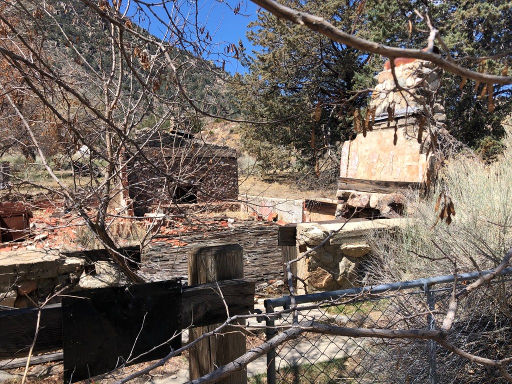
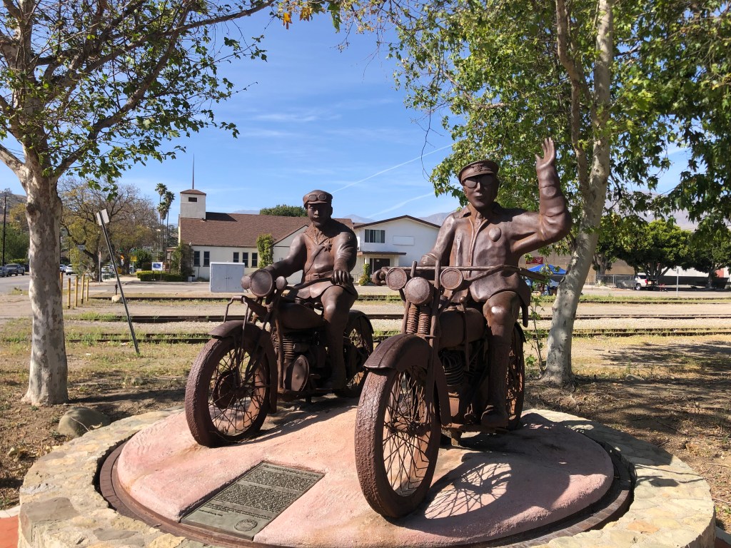
Now, I’d planned to take 33 to its end near the oceanfront in Ventura about 25 miles away. But on a whim I instead headed out of Ojai on highway 150 east, which took me to Santa Paula (pop: 30,000). This was one of the few decent-size cities I encountered on this trip. I always associate Santa Paula with the St. Francis dam disaster of 1928. The dam was dozens of miles away, but when it failed in the middle of the night it unleashed a wall of water that passed through canyons and took out hundreds of structures before it reached the ocean. A year ago I made a visit to the dam site and described the disaster here. Today in Santa Paula, I saw this monument commemorating two motorcycle police officers who alerted townspeople of the impending disaster.

Latter day Paul Reveres.

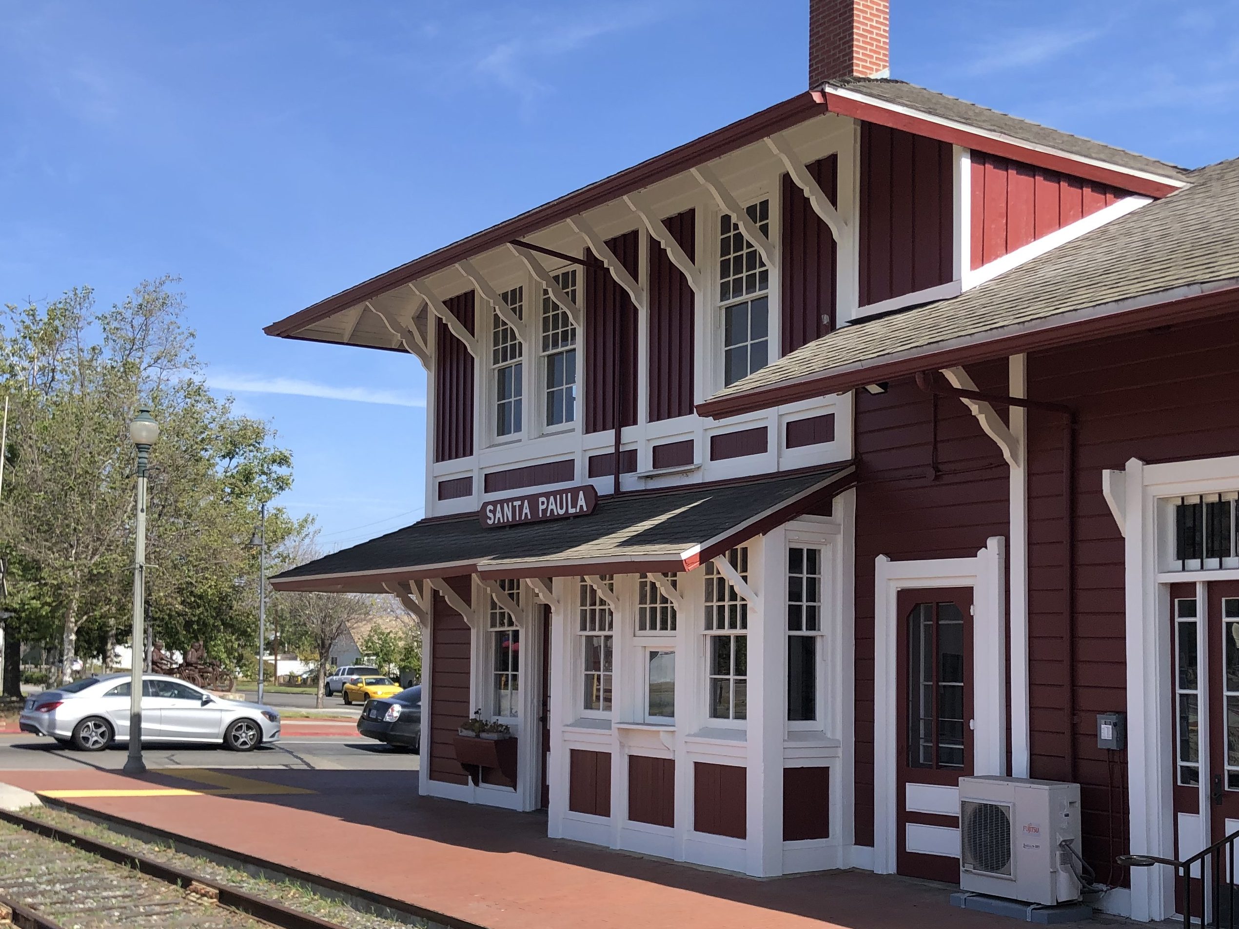
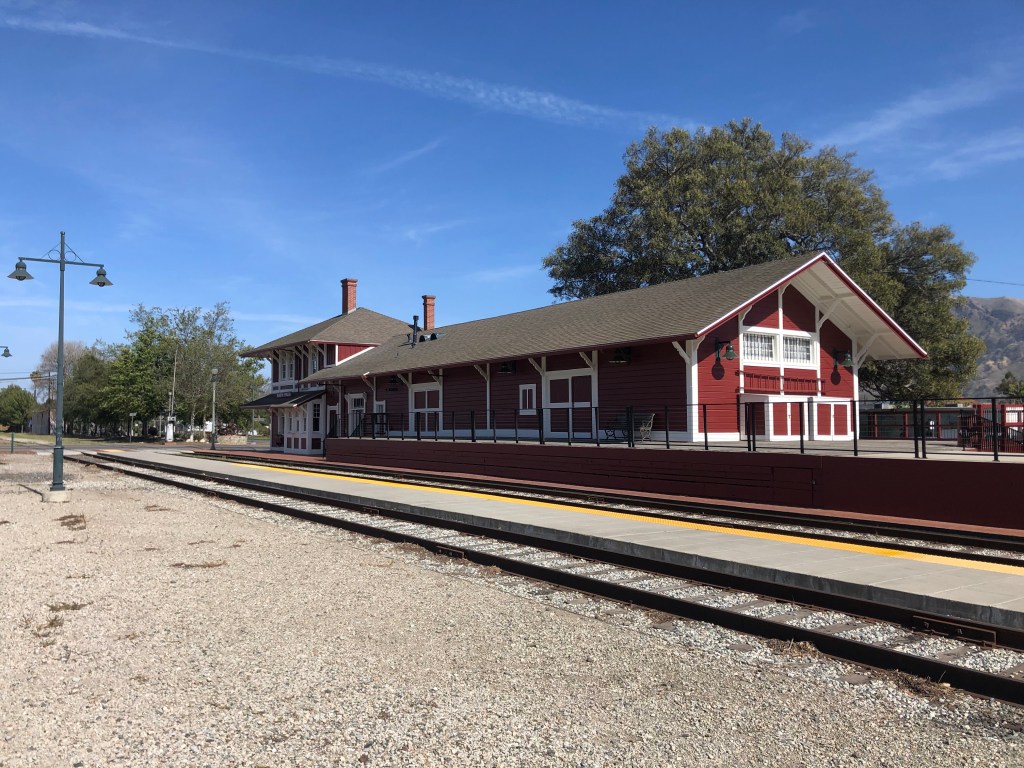
But the real treasure in Santa Paula, for me, is the old Southern Pacific railroad depot. It was built in 1887 and served as the center of commerce and passenger travel for many years. Passenger service was halted in the 1930s and freight in the 1970s. But the structure has been lovingly restored and today serves as the Chamber of Commerce’s headquarters and an art gallery. I’ve seen a lot of restored railroad depots in my day, but this one is among the absolute best. It appears vibrant and solid, and is really a thing of beauty.

Soon after Santa Paula, I connected with Interstate 5. As soon as I get on a freeway, I consider the trip to be over…even though I still had another hour and a half of driving. As I fought the LA traffic, I was thankful for two days of two-lane roads in the deserts, valleys, and mountains of California.
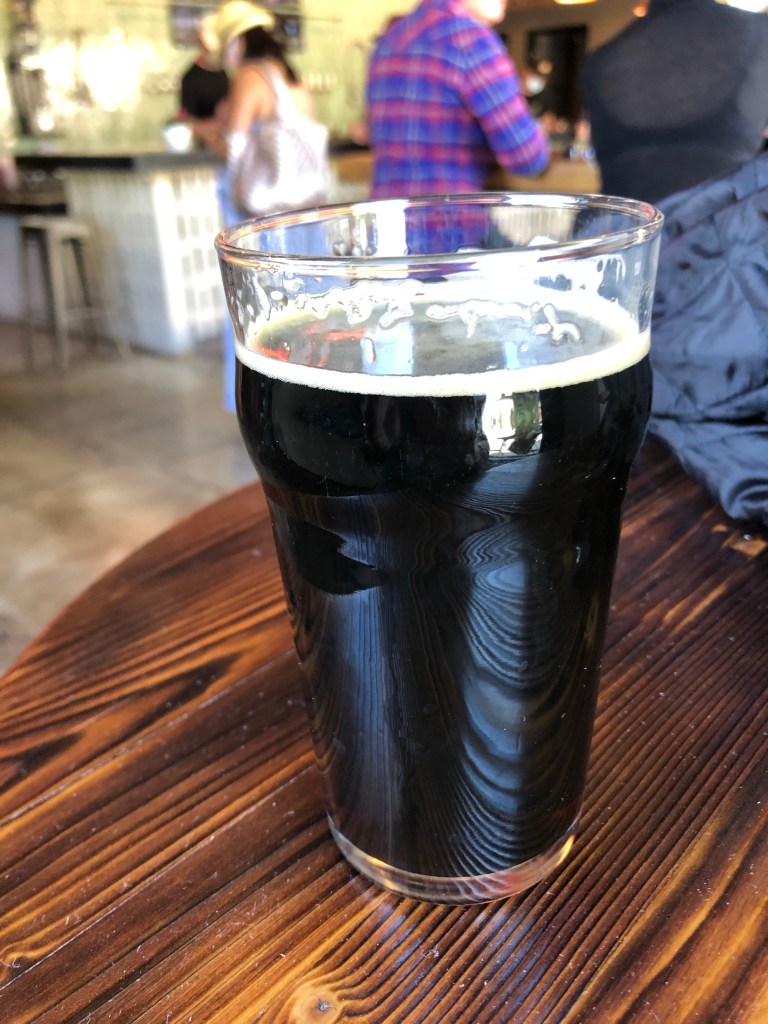
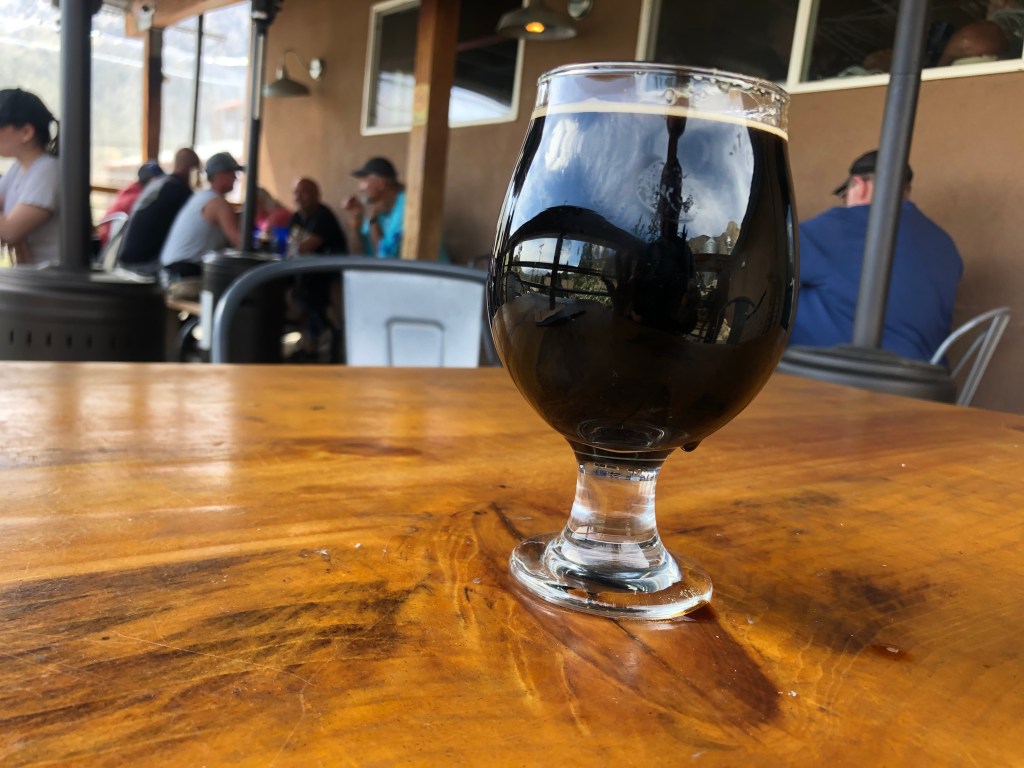
BREW OF THE DAY

I had my BOTD at a place called Topa Topa Brewing Company in Ojai. The place is about 6 years old, and is named after the nearby Topa Topa Mountains. It’s got lots of outdoor seating a very laid-back vibe, which is typical for an Ojai business.

Nice day for a beer.

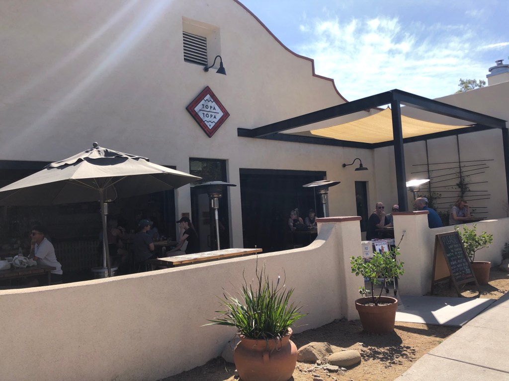
I chose the “Gadabout Stout.” Like yesterday’s BOTD, this is a nitro stout, which gives it a creamy mouthfeel. It’s brewed with coffee from the nearby Ragamuffin Roasters, and that gives it some decent roasty notes. But I have to say that I was underwhelmed by this beer. It’s made with oat milk, which while it may appeal to the Ojai hippies, seems to be an odd choice for beer. I suppose my main complaint is that the beer just feels flat and weak. It’s like drinking skim milk when you’re expecting a glass of whole milk. The beer doesn’t deliver much of a bite — either from hops or from alcohol. (It weighs in at 6% ABV). The main taste profile evokes corn cakes and unsalted tater tots. In a word, it’s bland. Definitely needs to be sharpened under a pyramid or healed with a crystal.

The Pone of Beers

California history · cemeteries · Road trips · Uncategorized

Stuff It In Yo’ Kern, Potsie!

It’s Springtime, I’ve had my Covid shot, so I figured it was time to take a short road trip. The basic idea was to head up through the Mojave on CA Route 14 to the town of Inyokern (so named because it straddles Inyo and Kern Counties), then head west over Walker Pass on CA Route 178. Upon reaching Lake Isabella, I’d take some winding back roads northwest over the Sierra Nevada and drop into Porterville. From there I’d make my way over to CA Route 33, and take it all the way down to Ventura. From there I’d head home on US 101.

My route seems to have taken on a Texas shape…

There was particular attraction about this route: it would give me a second chance to take that winding back road over the Sierra that I’d tried last Fall. For it was then that was stopped in my tracks by the so-called “SQF” fire. (That day is memorialized in this post from November 2020.)

So this morning I set out around 8 am. It was a perfect spring day. Soon I was heading up CA Route 14 through the desolation and despair that is the Antelope Valley.

Nobody here but us Joshua Trees.

A little further along the landscape got more interesting at Red Rock Canyon State Park.

I made a stop at Jawbone Canyon, which supposedly resembles a mandible. It’s managed by the BLM as an OHV park, but of greater interest to me is the enormous pipeline that conducts water from the Owens Valley all the way down to Los Angeles. The pipeline was the brainchild of William Mulholland, who had it constructed over a century ago. Leaving aside issues of water theft and environmental damage, it was an impressive engineering feat. I made a trip along that pipeline a couple of years ago, which you can read about here.

The pipeline at Jawbone Canyon. Jack Nicholson “nose” the back story…

While at Jawbone Canyon I happened upon a historic marker that described one Josephine “Josie” Stevens Bishop. Evidently, in addition to being a mother of seven, a school teacher, and an actress, she tried her hand at mining in this area and in 1937 discovered “the richest radium deposit known at the time.” She became famous and by leasing out her mining claim she is said to have become the richest woman in the world, for a time. The press gave her the nickname “The Radium Queen of the Desert.”

Desert Rat Josie Bishop : News Photo
The Radium Queen at her Castle.

Enriched by this story, I got back on the highway and eventually came to Inyokern (pop: 1,000). I turned onto CA Route 178 and took it up into the lower Sierra Nevada mountains. Eventually I got up to about 5,000 feet, where I encountered Walker Pass. Walker Pass was discovered by Joseph Rutherford Walker in 1834. This is the pass that the so-called “Lost 49ers” had sought as they ill-advisedly made their way across Death Valley. (Ian and I had learned about the Lost 49ers when we were in Death Valley a few months ago. See this post.)

There isn’t much in the way of civilization out this way. That’s one of the attractions of these trips — getting away from the crowds of Los Angeles and discovering California’s remote regions. Near Walker Pass I did see some signs of an earlier settlement, but what it was and what happened to it are stories unknown to me.

Passing Ghosts.

I also passed a Civil War-era cemetery.

The “Grove” part could use a good arborist.
Surprising that there are living folk still leaving mementos on this grave 140 years later.

A little further down the road I came to the village of Onyx (pop: 475). The Onyx Store, established in 1861, is said to be the oldest continually-operating store in the entire state. Since it was getting to be lunchtime, I figured I stop for a sandwich. Inside the store is all manner of merchandise, as one would expect in a general store. They also had a deli counter, and I set my sights on the “buckaroo plate” which promised a huge sandwich will all the trimmings. Alas, there was only one employee in the store, and she had evidently been hit with that alien ray from Star Trek that gets you to slow down to one-hundredth of normal speed. I waited for 10 minutes while she prepared the sandwich for the truck driver that was waiting. When she finally finished, I opened my mouth to place my order when the human statue pointed to a family of five and said “they were ahead of you.” I did a quick mental calculation and decided that I would probably get my lunch quicker if I just drove to the next town. Which I did.

Don’t expect “fast food.”

The next town turned out to be Lake Isabella (pop: 3,500). The town was preceded by the town of Isabella (no “Lake”), and was named after Spain’s Queen Isabella in 1893. (Evidently the Columbian Exposition of 1893 had resurrected interested in Queen Izzy.) But then, in 1953, the nearby Kern River was dammed and the newly-created reservoir inundated the original townsite. So the town of Lake Isabella was founded.

Near the dam is a place called “The Dam Korner” which, although it calls itself a “coffee shop,” serves all manner of burgers and sandwiches. So I ordered the special, which was a bacon and blue (not bleu, you understand; this is Kern County) burger with fries. The burger must have had close to a pound of meat, and there must have been a half a cup of blue/bleu cheese. The bacon was thick and plentiful. It was truly an impressive meal. It would have been great with a beer, but they only had the most basic, uninteresting panther piss. (This is what the waitress called it.) So I had it with water.

My check from lunch. Seems they can’t keep their lies straight about what constitutes a 20% tip.

My next stop was Kernville (pop: 1,300), which is just ten or 15 minutes further up along the lake shore. Like Isabella, Kernville was inundated when the dam was constructed, so the town was relocated on higher ground. It’s actually a fairly charming town, and it seemed to be bustling. I stopped at the Kern River Brewing Company to get that beer I’d missed at the Dam Korner. The place was crowded, but I found myself a seat on the patio and I ordered an imperial stout. (See the end of this post for my review of the Brew of the Day.) I asked the waitress if it’s always this busy, and she said the crowd is mainly due to Spring Break. Oh yeah. I forgot about that. It seems Kernville attracts a lot of the young ‘uns who want to hike or raft or, well, drink.

Welcome oasis in a county full of crappy beer.

Fortified with my Stout, I headed up into the mountains to re-try the route that eluded me last fall. I was heading along “Mountain Highway 99,” and all was right with the world. I was the only one on the road, the sky was blue, the sun was warm, and the trees were wearing their spring green.

And then.

Curses! Foiled again!

Once again, I was forced to turn back. It’s still not entirely clear to me why the road was closed this time, but it seems like it’s a “seasonal” closing that lasts until all the mountain snow has melted. I looked at my map, and decided to re-route myself over the Sierra range on CA 155. So I went back to Lake Isabella, where CA-155 begins, and drove for 75 miles to its terminus in Delano. This is where I’m spending the night.

Like most of the routes over the Sierras, CA 155 is a winding, beautiful, and soul-enriching road. It makes an elevation gain of about 6,000 feet before dropping down to the floor of California’s Central Valley. The scenery changes constantly, and once again I encountered almost no other drivers. It was a worthy detour.

Tomorrow I head over to CA Route 33, and drive south til I cross the Transverse Ranges and enter Ventura.

BREW OF THE DAY

Kern River Brewing Company had two different Imperial Stouts on tap. To help me decide, I was offered a taste of each. Both weighed in at 10.5% ABV. But one was much sweeter than the other. I went with the other.

My chosen beer was their Class X Imperial Stout. (It’s pronounced “Class Ten,” by the way. Like a yokel, I’d mistakenly called it “Class Eks.” It’s the opposite of the possibly apocryphal story about the news anchor in the 1960s who referred to the black Muslim activist as “Malcolm Ten.”)

I give it a X.

Anyway, the beer: Nectar Of The Gods. This stuff is amazing. It has the color of espresso and the consistency of chocolate milk. The taste is a veritable symphony of carbonized foodstuffs: burnt marshmallow, burnt molasses, and maybe some bacon fond and a little roux. Midway through you taste some Folgers coffee and Dr Pepper. Finally, there’s a distinct sense of burnt toast on the finish. And they serve it on nitro (that is, it’s infused with nitrogen, which smooths the beer out a bit.) I’m serious; this is one of the best imperial stouts I’ve had.

California history · Cars · Golden Bear signs · Road trips · Uncategorized

Bear-ly Surviving

When I was a wee lad, Babe’s Muffler Shop in San Jose had a giant fiberglass statue to advertise its business. This was one of the many “muffler men” that dominated the landscape in the 1960s. And a number of them still survive today. There seems to be a small but fanatical fan base for these roadside artifacts from another era.

But this post is not about Muffler Men. Instead, it explores an analogous phenomenon: Laughing Bears.

For around the same time as I was growing up in the shadow of Babe’s Muffler Man, I was also vaguely aware of several wheel alignment shops that sported a laughing, golden bear on their signs. The image of the Laughing Bear seems to have been buried in my subconscious, entirely forgotten until I moved to southern California a few years ago. And then, lo and behold, I re-encounted the Laughing Bear in Torrance, looking only a little worse for wear.

“You walked out of my dreams, into my arms….

The story of the Laughing Bear goes back a century. For in 1913, brothers Will and Henry Dammann founded Bear Manufacturing in Rock Island, Illinois. One of their first products was an electric starter for Henry Ford’s Model T. (Until then, starting your Model T required standing in front of the vehicle and turning a metal crank quickly. A startling number of individuals were run over by their own cars in this process.) So the Brothers Dammann had a popular item on their hands. Of course, Henry Ford being Henry Ford, he began manufacturing his own starters and undermined the Dammanns’ market. So Will and Henry shifted their focus to automotive diagnostic equipment.

Bear Manufacturing soon became a well-known and respected trainer of automotive mechanics. Their reputation led to their being appointed as the official servicing outfit for the Indy 500 for half the 20th Century. In 1949 Bear Manufacturing built an impressive, Streamline Moderne headquarters in Rock Island, housing the Bear School of Automotive Safety Service.

Naturally, the Bear name developed a certain cachet in the automotive industry, and thus being associated with Bear was considered to be good for sales. And so auto repair shops whose mechanics were trained by Bear would often erect signs with Bear’s “laughing bear” logo.

Alas, the Bear training school closed in the early 1970s, and the last vestiges of the company disappeared about twelve years ago. But many of the signs live on, referencing a training standard that no longer exists.

Over the past few months I’ve been keeping a list of all the Bear signs I’ve spotted in the South Bay area of Los Angeles. And today I went out and took photos of them. Here they are (in addition to the one from Torrance Auto Repair, above, which dates back to 1948):

Gardena Bear, Wheel Alignment. Sign originally erected around 1949.
B & D Wheel Alignment dates back to the 1960s.
Another shot of B & D. Note that they really seem to like that Bear logo…
This place obviously has no connection to auto repair. They opened in the early 2000s, presumably on the site of an old auto repair facility.
Chet himself is long gone, and the business seems to be closed. The sign, which dates back to the 1950s, survives. For now.
Forlorn sign at Chet’s. The quotation marks might have scared away customers.
Miller’s Wheel Alignment has been around since 1946. The sign has been repainted, and/or the laughing bear had a stroke.

And if these are reminding you of your Woodstock years, you’ve been listening to too much Grateful Dead.

Amazon.com: Grateful Dead – 5 Jerry Bears On Clear Background – 9.5" X 2.5"  Sticker / Decal: Automotive
Jerry Garcia steals from the Brothers Dammann.

I’m sure there are many more surviving Laughing Bear signs. Please send me pictures of any that you’re aware of! I’ll post them in a subsequent blog.

Also, stay tuned for my trip to visit the Bear Headquarters building in Rock Island, which I’m told is still standing. My wife has been encouraging me to take another road trip…

California history · Road trips · Uncategorized

Yea, though I walk through the Valley of Death…

A few weeks ago I took a weekend camping trip in Death Valley with son Ian (who was born unto me some 28 years ago). We had made an earlier trip to Death Valley in February 2019, in which I proceeded to drive the car into a snowbank moments after Ian handed over driving duties. (I may dig up that story and post it on this site on an upcoming Throwback Thursday).

The road was here just a moment ago!

Anyway, as I said, we recently made another trip into Death Valley, and this time, mercifully, we didn’t encounter any snow. Ian says that Death Valley is one of his favorite haunts (har!), because of its unique landscape: sand dunes, slot canyons, mountains, playas, etc. “Nowhere else have I found such a seemingly desolate area with so much to look at,” says he. The other advantage it has these days is the almost complete lack of humans. There’s no need to wear a Covid mask in Death Valley, because there’s no one else there! So, after fortifying ourselves with some bacon maple doughnuts from Sidecar, we set out for the northern Mojave Desert.

Maple Bacon Doughnuts from Sidecar Doughnuts and Coffee | Bacon donut,  Irresistible desserts, Maple bacon donut
Somehow appropriate for a journey to a place called Death Valley

Death Valley is a unique, impressive place. It hosts the lowest spot on the continent, at 282 feet below sea level. It holds the record for the hottest temperature on the face of the earth (134 degrees in 1913). It covers 3,000 square miles of variegated landscape, as Ian noted. It’s downright inhospitable, and yet its stark desolation has its own kind of beauty.

Death Valley - Students | Britannica Kids | Homework Help
One of the least detailed maps I’ve ever seen, from the good folks at Encyclopedia Britannica.

Leaving LA, we headed up the eastern Sierra on US 395, and took state route 190 to cross over the Panamint range. Eventually we dropped into Death Valley, where we found ourselves surrounded by….nothing.

Multiply by 3,000 square miles

The slow, twisting drive through the arid landscape was oddly relaxing, and the lack of cell service strengthened the sense of liberation from our sublunary cares. In the mid-afternoon we came to a simple, remote crossroads known as Teakettle Junction. It’s unclear exactly how it got its name, but at some point people took to hanging teakettles from the sign.

Teakettle Junction’s eponymous kitchenware.
Some of the tea kettles seem to be making statements.

Not far from Teakettle Junction is the storied “race track.” It’s a dry lakebed that now amounts to a large, perfectly flat oval of dirt surrounding a rock outcropping. The oval resembles a racetrack and the outcropping evokes (for some) grandstands.

Gentlemen, start your engines

But it’s the mysteriously moving rocks that are what the Racetrack is famous for. Scattered about on Racetrack are large boulders that have scraped long, straight wakes into the dirt as they evidently scooted across the flat lakebed. The cause of their movement was a mystery for many years, but a few years back some scientists installed GPS units on a handful of the rocks to track their movements. (I’m not making this up.) The researchers, who referred to their project as “the most boring experiment ever,” described their findings in a jargon-laden journal article, essentially concluding that the rocks get moved by wind when thin ice covers the ground.

Boulders leave a mysterious trail in a dry lakebed
(Photo from Death Valley National Park website)

As the sun began to drop behind the Cottonwood Mountains we decided to set up camp back near Teakettle Junction. “Camp” amounted to a relatively flat clearing beside the road. No wood fires are permitted in Death Valley, so we used a gas-fueled fire bowl to cook our dinner and keep ourselves warm as we sat in the dark drinking Japanese whisky. When it came time to bed down, Ian slept in a sleeping bag under the stars. I opted for the illusory safety of a small nylon tent to protect myself from the jackals. Ian insisted that no dangerous beasts would bother us, but I remembered the last time I camped in Death Valley I awoke to the sound of a jackal devouring some hapless animal right next to my tent. In the morning Ian pointed out there were no tracks or any other evidence of a nighttime visitor. But I read The Hound of the Baskervilles, and I know about spectral beasts.

Facing The Hound | The Hounds of Baskerville | Sherlock - YouTube
Nylon tent fabric is his kryptonite

The next morning we headed out to Ubehebe Crater. The crater, whose name is taken from a Paiute word that sounds to me like the name of Obi-Wan Kenobi’s wife, is enormous: about 600 feet deep and half a mile across. As we hiked around the rim I was thankful it wasn’t mid-summer.

“Hello there General Kenobi”

Next we headed south toward Badwater Basin (the lowest point in North America). Now, the sites of Death Valley are separated by vast distances on slow, dirt roads. So this is not a place where you rack up a large number of separate stops each day. Instead, you just let the immensity and desolation wash over you as you slowly move through the national park.

Along the way encountered the remains of the Harmony Borax Works.

Remains of Harmony Borax Works

As we all know, borax is a naturally-occurring mineral that historically has been used as a key ingredient in detergent and other household products. Borax was discovered in Death Valley in 1881, and a few years later the Harmony Borax Works was constructed to refine the ore. The refined product was shipped out of Death Valley on those 20-mule-team wagons that have become ensconced in the lore of the Old West.

Twenty-mule team - Wikipedia
Poor bastards

Continuing on through Badwater Basin, we came to Devil’s golf course, whose name, if you refer to the accompanying photo, is self-explanatory. The sharp, jagged surface is composed of decaying salt formations.

Devil’s golf course. Don’t ask for a mulligan.

Also during our drive through Badwater Basin we spotted a marker for Bennett’s Long Camp. We’d never heard of this before, and between the plaque and (later) Wikipedia, we put together the story of the Death Valley Forty-Niners. The story takes place in the fall of 1849, as the California Gold Rush was in full flower. A particular group of folks from the midwest arrived with their wagons in Utah, and decided it was too late in the season to try to cross the Sierras. (The remembered the tragic example of the Donner Party just a few years earlier.) So they decided to instead go around the southern end of the Sierras, enter California though the Mojave, and then head up to the goldfields through the Central Valley. What could go wrong?

California Historical Landmark #443: Valley Wells
With a name like Manly you know he’s a stud

The short version is that the group split into several smaller groups, and tried different “shortcuts.” But unreliable water sources, weakened oxen, and other challenges almost resulted in catastrophe. Miraculously, the Death Valley Forty-Niners made it to civilization with only one death. And as they were headed over the Panamint range toward their salvation, one of them purportedly looked back and said “Goodbye, death valley!” And the name has stuck ever since.

Ian and I eventually ended our camping trip and made our own trip back over the Panamint Mountains. When we got back down to the Panamint Valley we discovered a bright green mailbox sitting in the middle of nowhere, with a sign suggesting that it was connected with aliens somehow. As I’ve mentioned in other posts, there’s something about being in a desert wilderness that inspires unusual artists.

Intergalactic Post
Hope you used an airmail stamp

We made a final stop in the nearby ghost town of Ballarat. It was founded in 1897 to serve the nearby mines in the Panamint Mountains. The population (once as high as 500) declined precipitously after the mines played out in the early 20th century. Ballarat experienced brief notoriety in 1969 when Charles Manson and his “family” set up a camp here.

Sounds like suicide to me…
Ballarat’s hot water supply. Might be a little too hot.

These days Ballarat has a population of one: Rocky Novak, who claims to be the mayor. We saw him sitting on a chair in front of his house/general store. I’d highly recommend you invest five minutes seeing him in this short documentary:

We made it home with only one incident: A blowout a few miles after we left Ballarat. The tale of the Death Valley Forty-Niners kept our setback in perspective, and we were thankful for a spare tire, cell service, and an ice chest full of beer.

California history · churches · movie theaters

After Many Years

Editor’s note: Given limited travel opportunities these days, I decided each Thursday to post travel stories I’d written prior to starting this blog. The following is from a short trip I made into downtown LA before the Corona pandemic. I hope you might vicariously enjoy this trip while we’re all hunkering down at home.

Editor’s other note: Special prize to the first reader who identifies the reference in this blog’s title.

Today I headed into downtown Los Angeles to find a historic theater. But this story requires a little background:

My Dad used to watch a lot of TV (although the line between “watching” and “napping” was somewhat blurred). After Warriors basketball and the Solid Gold dancers, dad’s favorite television fare centered on a cranky, white-haired televangelist with a penchant for quirky headgear. Dr. Gene Scott began broadcasting from southern California in 1975. Unlike the better-known televangelists of the era, such as Oral Roberts and Jerry Falwell, Scott wasn’t slick or even particularly adroit as a preacher. He could be profane, often smoked a cigar while he talked to his TV “congregation,” and could wait out television viewers during a fund drive with interminable pauses and endless repetitions of a single clip of a barbershop quartet singing a white man’s spiritual. His nightly programs usually contained some meditations on a biblical passage, but much of the program was filled with Scott’s meandering musings about his clothes, postage stamps, or, eventually, his battles with the FCC and the IRS.

Says here I can’t claim my toupee as a dependent

Gene Scott used to broadcast from the historic (1927) United Artists’ theater building in downtown Los Angeles. He used the building’s auditorium to conduct worship services that were shown on TV stations across the country.

So this was my destination for today’s trip. I saddled up the Speedmaster and made my way to LA’s so-called fashion district. For the uninitiated, the fashion district isn’t really that fashionable. Here are a couple of the more respectable structures in the area:

For those in need of body parts
I’m not sure their definition of “luxury” is the same as mine

Eventually I found the UA building on a gentrifying stretch of Broadway. After almost 100 years, it’s still looking good:

Beware the Moors….

United Artists was founded in 1919 by D.W. Griffith, Charlie Chaplin, Douglas Fairbanks, and Mary Pickford. The four veterans from the silent era were reacting to efforts by Hollywood producers and distributors to tighten their grip on moviemaking. So they formed UA as a way to retain control over their own films. In 1927 they constructed this 13-storey building with a grand movie theater taking up the bottom three floors. Supposedly it was Mary Pickford’s love of Spanish castles that influenced the design.

Mary’s Folly

United Artists underwent many changes over the years, including an odd period in the early 2000s involving Tom Cruise. But the building has been a constant presence in downtown LA. The theater was capable to accommodating over around 1,600 moviegoers, and played host to many UA premiers and red-carpet events in its day.

Image result for interior of united artists building downtown la
Gilding the lily

Of course, as movie palaces became less popular in the television era, the United Artists’ theater was leased for other uses. And then in 1989, Gene Scott began using it to conduct his televised worship services. Scott eventually bought the whole building and restored much of its opulence from the Golden Age of movies. After Scott’s death in 2005 his widow sold the building to a boutique hotel chain. It’s now known as the Ace Hotel, although the theater continues to operate as an entertainment venue.

Sign of the times

One interesting feature from the Gene Scott era is a historic “Jesus Saves” neon sign that he had placed on the back of the building. I can’t speak to whether Jesus is directly responsible, but I’m glad that this landmark has been Saved.